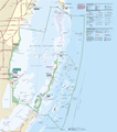
File:Biscayne National Park Map 2009.png

Size of this preview: 528 × 600 pixels. Other resolutions: 211 × 240 pixels | 423 × 480 pixels | 676 × 768 pixels | 902 × 1,024 pixels | 1,803 × 2,048 pixels | 3,391 × 3,851 pixels.
Original file (3,391 × 3,851 pixels, file size: 487 KB, MIME type: image/png)
File history
Click on a date/time to view the file as it appeared at that time.
| Date/Time | Thumbnail | Dimensions | User | Comment | |
|---|---|---|---|---|---|
| current | 19:39, 19 November 2012 |  | 3,391 × 3,851 (487 KB) | Acroterion | {{Information |Description ={{en|1=Official National Park Service map of Everglades National Park, Official National Park Service map of [[:en:Everglades Na... |
File usage
The following 5 pages use this file:
Global file usage
The following other wikis use this file:
- Usage on ar.wikipedia.org
- Usage on de.wikipedia.org
- Usage on en.wikivoyage.org
- Usage on es.wikipedia.org
- Usage on eu.wikipedia.org
- Usage on he.wikipedia.org
- Usage on it.wikipedia.org
- Usage on ru.wikipedia.org
- Usage on tr.wikipedia.org
- Usage on uk.wikipedia.org
- Usage on zh.wikipedia.org

