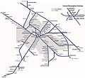
File:Birmingham & West Mids Passenger Railway Map.JPG

Size of this preview: 655 × 599 pixels. Other resolutions: 262 × 240 pixels | 525 × 480 pixels | 839 × 768 pixels | 1,248 × 1,142 pixels.
Original file (1,248 × 1,142 pixels, file size: 472 KB, MIME type: image/jpeg)
File history
Click on a date/time to view the file as it appeared at that time.
| Date/Time | Thumbnail | Dimensions | User | Comment | |
|---|---|---|---|---|---|
| current | 13:58, 27 February 2019 |  | 1,248 × 1,142 (472 KB) | G-13114 | Reverted to version as of 20:52, 19 December 2017 (UTC) Revert because 1) the map is wrong, the metro is in the wrong place and 2) it would be better to upload it as a new image if you must |
| 01:14, 25 February 2019 |  | 1,248 × 1,142 (489 KB) | RaviC | *Metro | |
| 01:11, 25 February 2019 |  | 1,248 × 1,142 (489 KB) | RaviC | Added Tramlink route | |
| 20:52, 19 December 2017 |  | 1,248 × 1,142 (472 KB) | G-13114 | Fix mistake | |
| 20:39, 19 December 2017 |  | 1,248 × 1,142 (472 KB) | G-13114 | Addition of Wilnecote station and Hatton and Bescot curves | |
| 12:18, 18 December 2017 |  | 1,248 × 1,142 (460 KB) | G-13114 | Fix mistake | |
| 12:13, 18 December 2017 |  | 1,248 × 1,142 (462 KB) | G-13114 | Added Coventry-Leamington line which was missing | |
| 04:51, 25 July 2016 |  | 1,248 × 1,142 (233 KB) | G-13114 | Tweaks | |
| 04:33, 25 July 2016 |  | 1,248 × 1,142 (233 KB) | G-13114 | Addition of Stoke + direction arrows | |
| 10:46, 7 July 2016 |  | 1,264 × 1,106 (210 KB) | G-13114 | Add grey area to denote WM county + trim whitespace at the edges |
File usage
The following 4 pages use this file:
Global file usage
The following other wikis use this file:
- Usage on fi.wikipedia.org
- Usage on ja.wikipedia.org
- Usage on ur.wikipedia.org


