
File:Basford North railway station.jpg
No higher resolution available.
Basford_North_railway_station.jpg (640 × 354 pixels, file size: 98 KB, MIME type: image/jpeg)
Summary
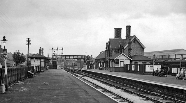
| Description | English: Basford North (former Basford & Bulwell) Station View eastward, towards Nottingham (Victoria), Colwick etc. and Grantham. Basford & Bulwell station only became 'Basford North' on 21/9/53; it was closed on 7/9/64 to passengers, along with the service from Derby (Friargate) etc. (goods 4/9/67). Beyond the station can be seen Park Lane Bridge, beyond which was the bridge carrying the main ex-Great Central line from Sheffield (Victoria) to Nottingham and the South. Trains through this station to/from Nottingham Victoria joined the main line at Bagthorpe Junction by connections either side of this bridge. A curve to the left just beyond the end of the Up (left) platform connected at Bulwell South Junction with the main line towards Sheffield. The lines straight ahead led to Leen Valley Junction and by the Daybrook Loop ('Back Line') round the north side of Nottingham to the great Colwick Yards and the main line to Grantham; the Back Line lost its meagre passenger services after the partial collapse of Mapperley Tunnel on 4/4/60, although Goods continued until 1/6/64. The GC main line effectively ceased as a through route on 5/9/66 and Nottingham Victoria closed on 5/7/67. |
| Date | |
| Source | From geograph.org.uk |
| Author | Ben Brooksbank |
| Permission (Reusing this file) |
Creative Commons Attribution Share-alike license 2.0 |
| Camera location | | View this and other nearby images on: OpenStreetMap |
|---|
Licensing

|
This image was taken from the Geograph project collection. See this photograph's page on the Geograph website for the photographer's contact details. The copyright on this image is owned by Ben Brooksbank and is licensed for reuse under the Creative Commons Attribution-ShareAlike 2.0 license. |
This file is licensed under the Creative Commons Attribution-Share Alike 2.0 Generic license.
Attribution: Ben Brooksbank
- You are free:
- to share – to copy, distribute and transmit the work
- to remix – to adapt the work
- Under the following conditions:
- attribution – You must give appropriate credit, provide a link to the license, and indicate if changes were made. You may do so in any reasonable manner, but not in any way that suggests the licensor endorses you or your use.
- share alike – If you remix, transform, or build upon the material, you must distribute your contributions under the same or compatible license as the original.
File history
Click on a date/time to view the file as it appeared at that time.
| Date/Time | Thumbnail | Dimensions | User | Comment | |
|---|---|---|---|---|---|
| current | 16:22, 20 April 2010 | | 640 × 354 (98 KB) | Andrewrabbott | == {{int:filedesc}} == {{Information |Description={{en|1=Basford North (former Basford & Bulwell) Station}} |Source=From [http://www.geograph.org.uk/photo/1768433 geograph.org.uk] |Date=1963-08-21 |Author=[http://www.geograph.org.uk/profile/44502 Ben Broo |
File usage
The following page uses this file:
Global file usage
The following other wikis use this file:
- Usage on www.wikidata.org