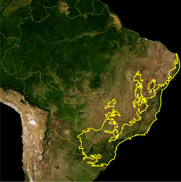
File:Atlantic Forest WWF.jpg

Size of this preview: 595 × 599 pixels. Other resolutions: 238 × 240 pixels | 477 × 480 pixels | 763 × 768 pixels | 1,017 × 1,024 pixels | 2,034 × 2,048 pixels | 2,877 × 2,897 pixels.
Original file (2,877 × 2,897 pixels, file size: 1.78 MB, MIME type: image/jpeg)
File history
Click on a date/time to view the file as it appeared at that time.
| Date/Time | Thumbnail | Dimensions | User | Comment | |
|---|---|---|---|---|---|
| current | 04:02, 24 July 2012 |  | 2,877 × 2,897 (1.78 MB) | Miguelrangeljr | {{Information |Description ={{en|1=This is a map location of the Atlantic Forest. The yellow line encloses Atlantic forest as delineated by the World Wide Fund for Nature. I, Miguelrangeljr, made it using NASA Blue Marble imagery and Corel D... |
File usage
The following 4 pages use this file:
Global file usage
The following other wikis use this file:
- Usage on ar.wikipedia.org
- Usage on ast.wikipedia.org
- Usage on ban.wikipedia.org
- Usage on be.wikipedia.org
- Usage on bg.wikipedia.org
- Usage on ca.wikipedia.org
- Usage on cs.wikipedia.org
- Usage on cy.wikipedia.org
- Usage on de.wikipedia.org
- Usage on de.wikivoyage.org
- Usage on eo.wikipedia.org
- Usage on es.wikipedia.org
- Usage on eu.wikipedia.org
- Usage on fa.wikipedia.org
- Usage on fi.wikipedia.org
- Usage on fr.wikipedia.org
- Usage on he.wikipedia.org
- Usage on hy.wikipedia.org
- Usage on ia.wikipedia.org
- Usage on id.wikipedia.org
- Usage on it.wikipedia.org
- Usage on ja.wikipedia.org
- Usage on lt.wikipedia.org
- Usage on ml.wikipedia.org
- Usage on nl.wikipedia.org
- Usage on nn.wikipedia.org
- Usage on no.wikipedia.org
- Usage on pl.wikipedia.org
- Usage on pt.wikipedia.org
View more global usage of this file.


