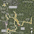
File:Atapuerca map.jpg

Size of this preview: 601 × 599 pixels. Other resolutions: 241 × 240 pixels | 481 × 480 pixels | 718 × 716 pixels.
Original file (718 × 716 pixels, file size: 186 KB, MIME type: image/jpeg)
File history
Click on a date/time to view the file as it appeared at that time.
| Date/Time | Thumbnail | Dimensions | User | Comment | |
|---|---|---|---|---|---|
| current | 14:19, 6 May 2017 |  | 718 × 716 (186 KB) | UtaUtaNapishtim | - Cueva del Fantasma removed (previous indication was mistaken, no location seems to have been released except 'near Sima del Elefante'). - Archeological places are highlighted to differenciate them from other formations |
| 10:37, 28 November 2016 |  | 718 × 720 (216 KB) | UtaUtaNapishtim | Deleted the misplaced arrow "Cueva del Fantasma", it is not on this map. | |
| 10:11, 18 August 2016 |  | 2,241 × 2,249 (1.5 MB) | UtaUtaNapishtim | Re-created to include more infos, bigger picture, cleaner key | |
| 20:23, 6 July 2016 |  | 1,000 × 1,000 (162 KB) | UtaUtaNapishtim | fixed new alpha issue re added contours for quicker understanding | |
| 20:12, 6 July 2016 |  | 1,000 × 1,000 (162 KB) | UtaUtaNapishtim | old scale=google, new scale=arsuaga et al., 'the site', 1997 better info colors optimized north added | |
| 16:41, 6 July 2016 |  | 1,000 × 1,000 (227 KB) | UtaUtaNapishtim | User created page with UploadWizard |
File usage
The following page uses this file:
Global file usage
The following other wikis use this file:
- Usage on ca.wikipedia.org
- Usage on es.wikipedia.org
- Usage on et.wikipedia.org
- Usage on fr.wikipedia.org
- Usage on it.wikipedia.org
- Usage on la.wikipedia.org
- Usage on nl.wikipedia.org
- Usage on no.wikipedia.org
- Usage on sv.wikipedia.org
- Usage on www.wikidata.org
