
File:Anerley, Anerley Road - geograph.org.uk - 1745779.jpg

Size of this preview: 800 × 533 pixels. Other resolutions: 320 × 213 pixels | 640 × 427 pixels | 1,024 × 683 pixels | 1,280 × 853 pixels | 2,560 × 1,707 pixels | 3,456 × 2,304 pixels.
Original file (3,456 × 2,304 pixels, file size: 5 MB, MIME type: image/jpeg)
Summary
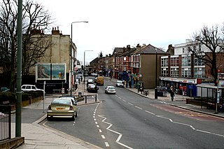
| Description | English: Anerley: Anerley Road This unremarkable road, which is part of the A214, runs from an end-on junction with Anerley Hill at the 'Paxton Arms', for almost a mile southeast to its crossroads with the A213, where used to stand, but is no more, a large public house known as the 'Robin Hood', see 39395. This pub was a local point of reference, so that certain buses would display 'Anerley, Robin Hood' on their blinds. The origin of the district name Anerley is of some interest. Many, many years ago, before railways or even canals, a certain Scotsman built a farm here. He could see no other habitation from his farm, so he gave it the name 'Aneley' - Scottish for 'lonely'. Not so aneley now. |
| Date | |
| Source | From geograph.org.uk |
| Author | Dr Neil Clifton |
| Attribution (required by the license) | Dr Neil Clifton / Anerley: Anerley Road / |
| Camera location | | View this and other nearby images on: OpenStreetMap |
|---|
_heading:135.00&language=en)
| Object location | | View this and other nearby images on: OpenStreetMap |
|---|
_heading:135.00&language=en)
Licensing

|
This image was taken from the Geograph project collection. See this photograph's page on the Geograph website for the photographer's contact details. The copyright on this image is owned by Dr Neil Clifton and is licensed for reuse under the Creative Commons Attribution-ShareAlike 2.0 license. |
This file is licensed under the Creative Commons Attribution-Share Alike 2.0 Generic license.
Attribution: Dr Neil Clifton
- You are free:
- to share – to copy, distribute and transmit the work
- to remix – to adapt the work
- Under the following conditions:
- attribution – You must give appropriate credit, provide a link to the license, and indicate if changes were made. You may do so in any reasonable manner, but not in any way that suggests the licensor endorses you or your use.
- share alike – If you remix, transform, or build upon the material, you must distribute your contributions under the same or compatible license as the original.
File history
Click on a date/time to view the file as it appeared at that time.
| Date/Time | Thumbnail | Dimensions | User | Comment | |
|---|---|---|---|---|---|
| current | 18:08, 5 March 2011 | | 3,456 × 2,304 (5 MB) | GeographBot | == {{int:filedesc}} == {{Information |description={{en|1=Anerley: Anerley Road This unremarkable road, which is part of the A214, runs from an end-on junction with Anerley Hill at the 'Paxton Arms', for almost a mile southeast to its crossroads with the |
File usage
The following page uses this file:
Global file usage
The following other wikis use this file:
- Usage on azb.wikipedia.org
- Usage on eu.wikipedia.org
- Usage on fa.wikipedia.org
- Usage on fr.wikipedia.org
- Usage on www.wikidata.org
- Usage on zh.wikipedia.org