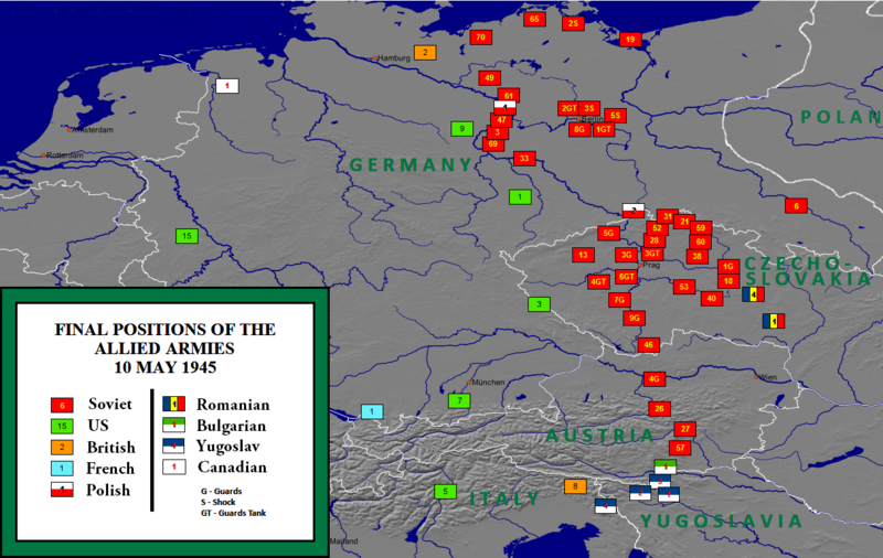
File:Allied army positions on 10 May 1945.png

Size of this preview: 800 × 506 pixels. Other resolutions: 320 × 202 pixels | 640 × 405 pixels | 1,024 × 648 pixels | 1,216 × 769 pixels.
Original file (1,216 × 769 pixels, file size: 550 KB, MIME type: image/png)
File history
Click on a date/time to view the file as it appeared at that time.
| Date/Time | Thumbnail | Dimensions | User | Comment | |
|---|---|---|---|---|---|
| current | 02:45, 2 November 2019 |  | 1,216 × 769 (550 KB) | Illegitimate Barrister | typos fixed |
| 14:08, 3 February 2018 |  | 1,216 × 769 (517 KB) | Ibn Battuta | changing the color scheme to make the French, UK & US armies more visible | |
| 14:03, 3 February 2018 |  | 1,216 × 769 (478 KB) | Ibn Battuta | changed the Polish icon - it was so close to being the national flag, now it *is* the national flag | |
| 13:23, 3 February 2018 |  | 1,216 × 769 (478 KB) | Ibn Battuta | deleted "and Soviet" [armies] because the Soviets were part of the Allied armies | |
| 15:39, 3 May 2013 |  | 1,216 × 769 (481 KB) | GCarty | Corrected the (pre-war) German-Polish border | |
| 16:10, 28 February 2013 |  | 1,216 × 769 (560 KB) | Harriv | Map legend improved by Reddit user [http://www.reddit.com/r/MapPorn/comments/19bsak/final_positions_of_the_allied_and_soviet_armies/c8mp43g BlueInq]. | |
| 06:09, 7 February 2011 |  | 1,217 × 769 (462 KB) | L'amateur d'aéroplanes | {{Information |Description ={{en|1=Allied army positions on 20 May 1945}} |Source =http://www.ibiblio.org/hyperwar/AAF/III/maps/AAF-III-map_564.jpg |Author =Inconnu |Date =2010 |Permission ={{PD-USGov-Military-Air_Force}} |
File usage
The following 6 pages use this file:
Global file usage
The following other wikis use this file:
- Usage on ar.wikipedia.org
- Usage on azb.wikipedia.org
- Usage on be-tarask.wikipedia.org
- Usage on bg.wikipedia.org
- Usage on bn.wikipedia.org
- Usage on de.wikipedia.org
- Usage on el.wikipedia.org
- Usage on es.wikipedia.org
- Usage on fa.wikipedia.org
- Usage on fr.wikipedia.org
- Usage on he.wikipedia.org
- Usage on it.wikipedia.org
- Usage on ja.wikipedia.org
- Usage on ka.wikipedia.org
- Usage on ko.wikipedia.org
- Usage on ms.wikipedia.org
- Usage on nl.wikipedia.org
- Usage on no.wikipedia.org
- Usage on pl.wikipedia.org
- Usage on pnb.wikipedia.org
- Usage on pt.wikipedia.org
- Usage on ro.wikipedia.org
- Usage on ru.wikipedia.org
- Usage on sh.wikipedia.org
- Usage on th.wikipedia.org
- Usage on tr.wikipedia.org
- Usage on uk.wikipedia.org
- Usage on ur.wikipedia.org
- Usage on vi.wikipedia.org
- Usage on xmf.wikipedia.org
- Usage on zh.wikipedia.org


