Langbahn Team – Weltmeisterschaft

File:APISmap1.pdf

Original file (1,283 × 1,522 pixels, file size: 118 KB, MIME type: application/pdf)

Description
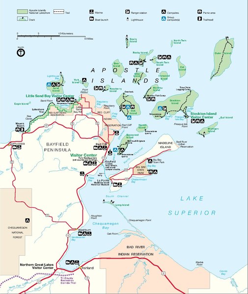
English: Park map produced by the National Park Service of the Apostle Islands National Lakeshore, on the Wisconsion south shore of Lake Superior. Located in Bayfeild and Ashland Counties, Wisconsin.
Date Unknown date
Source http://www.nps.gov/apis/planyourvisit/maps.htm
Author National Park Service, Department of the Interior
Permission
(Reusing this file)
Work of the US government, information from http://www.nps.gov/disclaimer.htm
Public domain This image or media file contains material based on a work of a National Park Service employee, created as part of that person's official duties. As a work of the U.S. federal government, such work is in the public domain in the United States. See the NPS website and NPS copyright policy for more information.

Captions

Add a one-line explanation of what this file represents

Items portrayed in this file

depicts

copyright status

public domain

applies to jurisdiction: United States
determination method or standard: work of the federal government of the United States

media type

application/pdf

checksum

80fbda6dc2184bb0bff06398bd592da44bfa647f

determination method or standard: SHA-1

data size

121,330 byte

height

1,522 pixel

width

1,283 pixel

number of pages

1

File history

Click on a date/time to view the file as it appeared at that time.

Date/TimeThumbnailDimensionsUserComment
current22:36, 15 November 2006Thumbnail for version as of 22:36, 15 November 20061,283 × 1,522 (118 KB)Mashtato{{Information |Description = Park map produced by the National Park Service of the Apostle Islands National Lakeshore, on the Wisconsion south shore of Lake Superior. Located in Bayfeild and Ashland Counties, Wisconsin. |Source = http://www.nps.gov/apis/p

Metadata