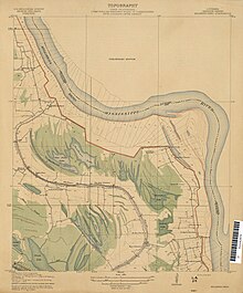
Duckport, Louisiana


Duckport (also Duck Port or Duckport Landing) was a plantation and boat landing in Madison Parish, Louisiana, United States,[2] best known today as one of the endpoints of the unsuccessful Duckport Canal project during the American Civil War. An alternate name for the Duckport Landing was Sparta or Sparta Landing.[3] As of 1890 two placenames were about 300 yards (270 m) apart on the Mississippi River, with Sparta preferred in high water and Duckport preferred in low.[4]
History
The settlement was originally known as Sparta and was described in Zadok Cramer's Navigator in 1817: "Good landing on the left side opposite [My Wife's Island], along a willow shore. The river bends to the right. This island is about 3 miles long. Opposite the head of No. 103 on the left shore, the old bed of the river formerly ran across to the Yazoo, and entered that ziver two miles above its present mouth. This tract is marked by the young willows with which it is now filled. Just below No. 103, on the right side, and in a right hand bend, is a considerable settlement, called SPARTA, on which resides judge Lindsey, below whose farm the river bears hard against the right hand bank, and it requires some pulling to keep out from among the fallen trees and snags near the shore. The bank having given way considerably in one place, an eddy is formed, but it presents no danger if you ply the oars well and keep pretty well out."[5] My Wife's Island was noted in 1851 as a particular River navigation hazard (where ships were prone to major hull damage from underwater snags and sawyers), along with "Plum Point, Turkey Island, Dogtooth Bend, Riddle's Point, Number Ten, Devil's Island, Hull's Left Leg, Elk Island, Number Twenty-One, Devil's Backbone, Devil's Tea Table, Hanging Dog's Island, Devil's Elbow, Tyawapita...Shirt-tail Bend, Grand Chain, Goose Island and the Grave Yard."[6]
In the 19th century, Duckport Landing was located between Paw Paw Island and Young's Point along the Mississippi River.[1] There was a boat landing at Duckport that was used by mail packet steamboats beginning sometime before 1852.[7] In 1869, the application for a Duck Port post office stated there were about 150 families in the vicinity who would be served by the station.[8] There was a series of suspicious fires at Duckport in 1885–86 that totaled a home at Sparta Landing, a storehouse, and a lumber warehouse.[9]
The sternwheel packet boat Ben Hur burned and sank at Duckport in March 1916.[10] Duckport was flooded in spring 1922.[11] There was an illegal 150-gallon still in operation near Duckport during Prohibition.[12] A fragment of the civil war-era canal was still visible in 1933 from a gravel road that ran from Thomaston to Duckport.[13][14] Thomaston Road had been the "center of wealth" in the area before the war and had been lined with plantation houses.[15] By the 21st century, all that was left of the canal was "a small indentation because area farmers tried to plow it down."[15]
The Duckport Plantation encompassed about 1800 acres as of the 1990s.[16] Duckport Landing no longer exists and has disappeared under the Mississippi River.[17]

See also
References
- ^ a b "Historic names and places on the lower Mississippi River / by Marion Bragg". HathiTrust. p. 155. hdl:2027/uc1.$c32669. Retrieved 2024-08-04.
- ^ "Duck Port (historical)". Geographic Names Information System. United States Geological Survey, United States Department of the Interior. Retrieved November 21, 2024.
- ^ "Mississippi River. Table of distances from Cairo to the passes. Comp. from the surveys of the Mississippi River Commission, 1883". HathiTrust. p. 10. Retrieved 2024-08-04.
- ^ "Until Further Notice". The Daily Commercial Herald. 1890-01-30. p. 4. Retrieved 2024-12-16.
- ^ "The navigator, containing directions for navigating the Monongahela, Allegheny, Ohio and Mississippi Rivers : with an ample account of these much admired ..." HathiTrust. p. 184. Retrieved 2024-12-15.
- ^ "Last Snag and Sawyer Convention". The Times-Picayune. 1852-02-22. p. 3. Retrieved 2024-12-16.
- ^ "Vicksburg-area packet boats". The New Orleans Crescent. 1852-09-29. p. 3. Retrieved 2024-08-04.
- ^ U.S. Post Office Department, "Louisiana: La Salle–Morehouse Parishes (Roll 243)", M1126: Post Office Department Reports of Site Locations, 1837–1950, Washington, D.C.: U.S. National Archives and Records Administration, film images 676–683 of 901, NAID 68406066 – via archives.gov
- ^ "Fire at Duckport". Weekly Commercial Herald. 1886-02-26. p. 5. Retrieved 2024-12-16.
- ^ "Ben Hur (Packet, 1887–1916)". UWDC - UW-Madison Libraries. Retrieved 2024-08-06.
- ^ "The Swollen Mississippi". Slate Magazine. 2011-05-20. Retrieved 2024-08-04.
- ^ "As Time Goes By". The Madison Journal. 1993-01-06. p. 7. Retrieved 2024-08-04.
- ^ "Know Louisiana; a tourist guide to points of general and historic interest. Issued for free distribution in connection with Louisiana highway commission ..." HathiTrust. pp. 27–28. hdl:2027/uiug.30112099802081. Retrieved 2024-08-04.
- ^ "Louisiana place-names of Indian origin no.2". HathiTrust. p. 22. hdl:2027/mdp.39015030547643. Retrieved 2024-08-04.
- ^ a b "Who we are". The News-Star. 2002-06-30. p. 143. Retrieved 2024-08-04.
- ^ "Legals". Tensas Gazette. 1991-09-11. p. 13. Retrieved 2024-08-04.
- ^ "Civil War markers erected". The Madison Journal. 1994-04-27. p. 5. Retrieved 2024-08-04.
