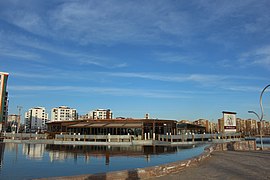
Diyarbakır Province
Diyarbakır Province Diyarbakır ili | |
|---|---|
 | |
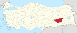
 Location of the province within Turkey | |
| Country | Turkey |
| Seat | Diyarbakır |
| Government | |
| • Governor | Ali İhsan Su |
Area | 15,101 km2 (5,831 sq mi) |
| Population (2022)[1] | 1,804,880 |
| • Density | 120/km2 (310/sq mi) |
| Time zone | UTC+3 (TRT) |
| Area code | 0412 |
| Website | www www |
Diyarbakır Province (Turkish: Diyarbakır ili; Zazaki: Suke Diyarbekir;[2] Kurdish: Parêzgeha Amedê)[3] is a province and metropolitan municipality in southeastern Turkey. Its area is 15,101 km2,[4] and its population is 1,804,880 (2022).[1] The provincial capital is the city of Diyarbakır. The Kurdish majority province is part of Turkish Kurdistan.[5][6]
History
It has been home to many civilisations and the surrounding area including itself is home to many Mesolithic era stone carvings and artifacts. The province has been ruled by the Akkadians, Hurrians, Mittani, Medes, Hittites, Armenians, Arameans, Neo-Babylonians, Achaemenids, Greeks, Romans, Parthians, Byzantium, Sassanids, Arabs, Seljuk Empire, Mongol Empire, Safavid dynasty, Marwanids, and Ayyubids.
Administrative history
In June 1927, the Law 1164 was passed[7] allowing the creation of Inspectorates-General (Turkish: Umumi Müffetişlik).[8]
The Diyarbakır province was therefore included in the First Inspectorate General (Turkish: Birinci Umumi Müffetişlik), which was created on the 1 January 1928 and also included Hakkâri, Siirt, Van, Mardin, Bitlis, Sanlıurfa, and Elaziğ.[9][10]
The Inspectorate-General was governed by an Inspector General, who governed with a wide-ranging authority over civilian, juridical and military matters.[8] The office of the Inspector General was dissolved in 1952 during the government of the Democrat Party.[11]
During the 1930s, several place-names in the province were renamed into names which denoted a Turkish origin as part of the nationalist Turkification policy of the Kemalist government.[12] Travel to Diyarbakır province was banned for foreign citizens until 1965.[9]
Modern history
In the 1975 Lice earthquake a Ms 6.7 struck the town of Lice. The town was re-established about 2 km (1.2 mi) south of its original location.
From 1987 to 2002, Diyarbakır Province was part of the OHAL (state of emergency) region which was declared to counter the Kurdistan Workers' Party (PKK) and governed by a so-called Supergovernor who got invested with additional powers than a normal Governor. In 1987 he was given the power to relocate and resettle whole villages, settlements and hamlets.[13] In December 1990 with the Decree No. 430, the supergovernor and the provincial governors in the OHAL region received immunity against any legal prosecution in connections with actions they made due to the powers they received with the Decree No. 430.[14]
Archaeology
Archaeologists headed by the vice-rector of Dicle University, professor Ahmet Tanyıldız, have claimed to discover the graves of the Seljuk Sultan of Rum Kilij Arslan I, who defeated the Crusaders. They also revealed his daughter Saide Hatun's burial in Silvan. Researchers dug 2 meters deep across a 35-square-meter area and focused their works on two gravesites in Orta Çeşme Park.[15][16]
Districts

Diyarbakır province is divided into 17 districts:
Population
| Assyrian and Armenian population in Diyarbakır Province in 1915-1916[17] | |||||
| Sect | Before World War I | Disappeared (killed) | After World War I | ||
|---|---|---|---|---|---|
| Armenians | Gregorians (Apostolic) | 60,000 | 58,000 (97%) | 2,000 | |
| Armenian Catholics | 12,500 | 11,500 (92%) | 1,000 | ||
| Assyrians | Chaldean Catholics | 11,120 | 10,010 (90%) | 1,110 | |
| Syriac Catholic | 5,600 | 3,450 (62%) | 2,150 | ||
| Syriac Orthodox | 84,725 | 60,725 (72%) | 24,000 | ||
| Protestants | 725 | 500 (69%) | 2,150 | ||
See also
References
- ^ a b "Address-based population registration system (ADNKS) results dated 31 December 2022, Favorite Reports" (XLS). TÜİK. Retrieved 19 September 2023.
- ^ Zazaca -Türkçe Sözlük, R. Hayıg-B. Werner
- ^ "Odeya Pizîşkên Amedê: 200 kes bi koronayê ketine". Rûpela nû (in Kurdish). 8 April 2020. Retrieved 27 April 2020.
- ^ "İl ve İlçe Yüz ölçümleri". General Directorate of Mapping. Retrieved 19 September 2023.
- ^ Watts, Nicole F. (2010). Activists in Office: Kurdish Politics and Protest in Turkey (Studies in Modernity and National Identity). Seattle: University of Washington Press. p. 167. ISBN 978-0-295-99050-7.
- ^ "Kurds, Kurdistān". Encyclopaedia of Islam (2 ed.). BRILL. 2002. ISBN 9789004161214.
- ^ Aydogan, Erdal. "Üçüncü Umumi Müfettişliği'nin Kurulması ve III. Umumî Müfettiş Tahsin Uzer'in Bazı Önemli Faaliyetleri". Retrieved 8 April 2020.
- ^ a b Bayir, Derya (2016-04-22). Minorities and Nationalism in Turkish Law. Routledge. p. 139. ISBN 978-1-317-09579-8.
- ^ a b Jongerden, Joost (2007-01-01). The Settlement Issue in Turkey and the Kurds: An Analysis of Spatical Policies, Modernity and War. BRILL. pp. 53. ISBN 978-90-04-15557-2.
- ^ Umut, Üngör. "Young Turk social engineering : mass violence and the nation state in eastern Turkey, 1913- 1950" (PDF). University of Amsterdam. p. 258. Retrieved 8 April 2020.
- ^ Bozarslan, Hamit (2008-04-17). Fleet, Kate; Faroqhi, Suraiya; Kasaba, Reşat; Kunt, I. Metin (eds.). The Cambridge History of Turkey. Cambridge University Press. p. 343. ISBN 978-0-521-62096-3.
- ^ Üngör, Uğur (2011), The Making of Modern Turkey: Nation and State in Eastern Anatolia, 1913–1950. Oxford: Oxford University Press, p. 244. ISBN 0-19-960360-X.
- ^ Jongerden, Joost (2007). The Settlement Issue in Turkey and the Kurds. Brill. pp. 141-142. ISBN 978-90-47-42011-8.
- ^ Norwegian Refugee Council/Global IDP Project (4 October 2002). "Profile of internal displacement: Turkey" (PDF). p. 78.
- ^ Gershon, Livia. "Turkish Archaeologists Discover Grave of Sultan Who Defeated Crusaders". Smithsonian Magazine. Retrieved 2021-01-20.
- ^ AA, DAILY SABAH WITH (2021-01-13). "Anatolian Seljuk Sultan Kılıç Arslan I's grave found in SE Turkey". Daily Sabah. Retrieved 2021-01-20.
- ^ Gaunt, David. Massacres, Resistance, Protectors: Muslim-Christian Relations in Eastern Anatolia during World War I. Piscataway, N.J.: Gorgias Press, 2006, p. 433.
External links
- (in English) Pictures of the capital of this province
- (in English) Diyarbakir Weather Forecast Information Archived 2009-02-12 at the Wayback Machine
- (in English) Historical Armenian presence in Diyarbakir Province
- Tourism information is available in English at the Southeastern Anatolian Promotion Project site.
- (in English) Diyarbakir Live News


