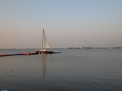
Dapeng Bay
| Dapeng Bay | |
|---|---|
| 大鵬灣 (Chinese) | |
  Dapeng Bay is located at the south of Donggang Township | |
| Location | Donggang, Pingtung County, Taiwan |
| Coordinates | 22°26′46″N 120°28′30″E / 22.44611°N 120.47500°E |
| Type | Lagoon |
| River sources | Linbian River(林邊溪) |
| Managing agency | Dapeng Bay National Scenic Area Administration,Tourism Bureau,Ministry of Transportation and Communications |
| Designation | national scenic areas |
| Average depth | 3 m (9.8 ft) |
| Dapeng Bay | |||||||||
|---|---|---|---|---|---|---|---|---|---|
| Traditional Chinese | 大鵬灣 | ||||||||
| Simplified Chinese | 大鹏湾 | ||||||||
| Literal meaning | Peng or Roc Bay | ||||||||
| |||||||||
Dapeng Bay or Dapeng Wan[1] is a lagoon in Donggang Township, Pingtung County, Taiwan. It is the largest lagoon on the southwest coastline of Taiwan Island.
Scenic Area
The Dapeng Bay National Scenic Area is a nationally protected area that includes the bay as well as nearby Liuqiu Island.
Transportation
The bay is accessible within walking distance west of Zhen'an Station of Taiwan Railways Administration.
References
External links
- Dapeng Bay National Scenic Area (governmental site)
- "Map: Dapeng Bay, 2013 Tour de Taiwan". Cycling iQ. Archived from the original on 31 August 2014. Retrieved 31 August 2014.
- "Taiwan from the Air--Chopper Shots: %. Dapeng Bay". Archived from the original on 31 August 2014.

