Cyclone Gaja
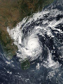
 Cyclone Gaja nearing South India on November 15 | |
| Meteorological history | |
|---|---|
| Formed | November 10, 2018 |
| Remnant low | November 19, 2018 |
| Dissipated | November 22, 2018 |
| Very severe cyclonic storm | |
| 3-minute sustained (IMD) | |
| Highest winds | 130 km/h (80 mph) |
| Lowest pressure | 976 hPa (mbar); 28.82 inHg |
| Category 1-equivalent tropical cyclone | |
| 1-minute sustained (SSHWS/JTWC) | |
| Highest winds | 150 km/h (90 mph) |
| Lowest pressure | 963 hPa (mbar); 28.44 inHg |
| Overall effects | |
| Fatalities | 52 total |
| Damage | $775 million (2018 USD) |
| Areas affected | Southern Vietnam, Malay Peninsula, Andaman Islands, Sri Lanka, Southern India (Tamil Nadu, Puducherry) |
| IBTrACS | |
Part of the 2018 North Indian Ocean cyclone season | |
Cyclone Gaja was the sixth named cyclone of the 2018 North Indian Ocean cyclone season, after Cyclones Sagar, Mekunu, Daye, Luban, and Titli. Forming on November 5 as a low-pressure system over the Gulf of Thailand, the system crossed through Southern Thailand and the Malay Peninsula and eventually crossed into the Andaman Sea. The weak system intensified into a depression over the Bay of Bengal on November 10 and further intensified to a cyclonic storm on November 11, being named Gaja. After tracking west-southwestward for a number of days in the Bay of Bengal, Gaja made landfall in South India on November 16, moved westward through Vedaranyam, Thiruthuraipoondi, Mannargudi, Muthupet, Pudukkottai, Adirampattinam, Pattukkottai, and Peravurani. The storm survived its crossing into the Arabian Sea; however, it degenerated into a remnant low in hostile conditions only a few days later, before dissipating early on November 22. 45 people were killed by the storm. 8 people were killed in the town of Pattukottai alone. Gaja had severe impacts in South India, particularly in Tamil Nadu. After Cyclone Gaja, Tamil Nadu sought Rs 15,000 crore from Indian central government to rebuild.
Meteorological history

Tropical storm (39–73 mph, 63–118 km/h)
Category 1 (74–95 mph, 119–153 km/h)
Category 2 (96–110 mph, 154–177 km/h)
Category 3 (111–129 mph, 178–208 km/h)
Category 4 (130–156 mph, 209–251 km/h)
Category 5 (≥157 mph, ≥252 km/h)
Unknown
On November 5, a low-pressure system formed over the Gulf of Thailand. The system crossed through Southern Thailand and the Malay Peninsula on November 8. The next day, it crossed into the Andaman Sea and lingered there, organizing further throughout the day and intensified into a depression over the Bay of Bengal on November 10. The next day, the system was designated by the IMD as BOB 09. Soon after, the Joint Typhoon Warning Center (JTWC) issued a Tropical Cyclone Formation Alert (TCFA).
At 00:00 UTC on November 11, the deep depression strengthened into a cyclonic storm, and was given the name Gaja by the IMD. After tracking west-southwestward for a number of days, it made landfall at Vedaranyam near Nagapattinam in southern India, early on November 16, as a very severe cyclonic storm. Afterward, Gaja passed through Vedaranyam, Voimedu, Muthupet, Pattukkottai, Adirampattinam, and Mallipattinam on the same day. The storm survived crossing over into the Arabian Sea later that day and continued moving westward; however, it degenerated into a remnant low in hostile conditions only a few days later, on November 19. A couple of days later, early on November 22, the storm's remnants dissipated near Socotra.
Preparation, impacts and aftermath
Due to the possibility of adverse effects in the coastal regions of Tamil Nadu and Puducherry, early steps were taken by the state governments. About 80,000 were evacuated to 470 relief camps from the districts which were vulnerable to the cyclone in Tamil Nadu.[1] Holidays were also announced in the coastal districts of the Cauvery delta region in Tamil Nadu as well as Puducherry.[2] People were advised not to come out of the house, as the cyclone caused high winds. Preventative measures were explained through all media.[3]
At the time of landfall of the cyclone, heavy winds of about 175–180 km/h speed were experienced. The highest wind gust was recorded in Adhirampattinam at 181 km/h, and Muthupet recorded a wind gust of 180 km/h. Regions of Karaikal and Nagapattinam also experienced 100 km/h winds. The affected areas were the districts of Nagappattinam, Thanjavur, Thiruvarur, Pudukottai, Karaikal, Trichy and Ramanathapuram.[citation needed] About 86 thousand electric poles, eight hundred transformers, two hundred electricity substations, and 5 thousand boats were destroyed by the cyclone. Thousands of birds and livestock died due to the cyclone.[4] About 18 thousand hectares of coconut trees were damaged, mostly uprooted. 56 thousand hectares of crops and trees were destroyed due to the cyclone.[5] 52 people died, mostly in the districts of Thiruvarur, Thanjavur, and Nagapattinam.[6]
See also
References
- ^ "Gaja wreaks havoc in T.N." The Hindu. 2018-11-17. ISSN 0971-751X. Retrieved 2018-12-05.
- ^ "Cyclone Gaja likely to hit TN on Thursday evening; holiday declared for schools in some districts and 16 trains cancelled – Times of India". The Times of India. Retrieved 2018-12-05.
- ^ "Cyclone Gaja: TN government braces up itself for the calamity". India Today. November 16, 2018. Retrieved 2018-12-05.
- ^ "Donations pour in for TN in the aftermath of Cyclone Gaja". 21 November 2018.
- ^ Revathy, L. N.; Kumar, Sajeev. "When perennial crops fall prey to nature's fury..." businessline. Retrieved 2018-12-05.
- ^ Jesudasan, Dennis (December 11, 2018). "Cyclone death toll revised from 63 to 52". The Hindu. Retrieved December 29, 2021.
External links
- 'Gaja second strongest cyclone since 1996' – The New Indian Express

