Codell, Kansas
Codell, Kansas | |
|---|---|
 Codell Kansas Cyclone Day Memorial (2018) | |
 | |
| Coordinates: 39°11′43″N 99°10′12″W / 39.19528°N 99.17000°W[1] | |
| Country | United States |
| State | Kansas |
| County | Rooks |
| Township | Township 12 |
| Founded | 1887 |
| Elevation | 2,011 ft (613 m) |
| Population | |
• Total | 49 |
| Time zone | UTC-6 (CST) |
| • Summer (DST) | UTC-5 (CDT) |
| ZIP code | 67663 |
| Area code | 785 |
| FIPS code | 20-14575 |
| GNIS ID | 2804531[1] |
Codell is a census-designated place (CDP) in Rooks County, Kansas, United States.[1] As of the 2020 census, the population was 49.[2]
History
Codell was established as a Union Pacific Railroad depot in 1887. Union Pacific could not reach agreement with the town of Motor, so Union Pacific established the community of Codell three-quarters of a mile west of Motor. The Motor Post Office, originally established as Floreyville in 1875, was moved to Codell in 1888. The frame buildings in Motor were moved to Codell and Motor was soon abandoned.[3]
Early in its history Codell had a school, multiple churches and a business district with a bank, telephone central office, lumber yard, grain elevator, several stores, a doctor and a barber.[4]
Tornadoes
Codell is notable for its tornado history which earned it a mention in Ripley's Believe It or Not!. The community was hit by tornadoes on May 20 in three consecutive years: 1916, 1917 and 1918.[5]
The 1916 tornado, estimated at F2 intensity, passed east of Codell in the early evening.[6] The 1917 tornado reached F3 intensity and passed west of Codell, also in the early evening.[7] In 1918, Codell took a direct hit from an F4 tornado just after dark. The school, M. E. church, hotel and several residences were completely destroyed. Many more buildings were badly damaged. Although the school was rebuilt and a new high school was built in 1938, the town never fully recovered from the devastation of the 1918 tornado.[8]
Geography
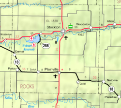
Codell lies in Township 12 south of the city of Stockton (the county seat of Rooks County[9]) and near the southeastern corner of Rooks County. The community lies along the banks of Paradise Creek and an abandoned railroad line. The nearest city, Plainville, lies approximately 9 miles (14 km) away to the northwest by road; the community is connected via 24 Road to a state highway, K-18, which lies approximately 1 mile (1.6 km) to the north.[10]
Demographics
| Census | Pop. | Note | %± |
|---|---|---|---|
| 2020 | 49 | — | |
| U.S. Decennial Census | |||
The 2020 United States census counted 49 people, 16 households, and 11 families in Codell.[11][12] The population density was 65.2 per square mile (25.2/km2). There were 23 housing units at an average density of 30.6 per square mile (11.8/km2).[12][13] The racial makeup was 95.92% (47) white or European American (95.92% non-Hispanic white), 0.0% (0) black or African-American, 0.0% (0) Native American or Alaska Native, 0.0% (0) Asian, 0.0% (0) Pacific Islander or Native Hawaiian, 0.0% (0) from other races, and 4.08% (2) from two or more races.[14] Hispanic or Latino of any race was 0.0% (0) of the population.[15]
Of the 16 households, 18.8% had children under the age of 18; 56.2% were married couples living together; 25.0% had a female householder with no spouse or partner present. 31.2% of households consisted of individuals and 18.8% had someone living alone who was 65 years of age or older.[12] The average household size was 2.2 and the average family size was 2.2.[16] The percent of those with a bachelor’s degree or higher was estimated to be 53.1% of the population.[17]
16.3% of the population was under the age of 18, 14.3% from 18 to 24, 16.3% from 25 to 44, 40.8% from 45 to 64, and 12.2% who were 65 years of age or older. The median age was 49.2 years. For every 100 females, there were 104.2 males.[12] For every 100 females ages 18 and older, there were 105.0 males.[12]
The 2016-2020 5-year American Community Survey estimates show that the median household income was $73,512 (with a margin of error of +/- $5,277) and the median family income was $73,512 (+/- $5,277).[18] Males had a median income of $41,071 (+/- $9,669). The median income for those above 16 years old was $40,536 (+/- $2,397).[19]
Education

Codell is served by USD 270 Plainville Schools.[20]
Codell High School was closed through school unification in 1965.[21] The Codell High School mascot was Codell Cougars.[22]
Arts and culture
Points of Interest
- Cyclone Day Memorial constructed in 2018 and dedicated on the 100th anniversary of the last May 20 cyclone.[23]
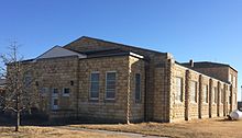
- Historic limestone school and Cougar Gymnasium constructed in 1938 as a WPA project.
- Church building constructed in 1908. The building withstood the tornadoes of 1916, 1917 and 1918.
- King Hill located four miles south of Codell on Codell Road. The picturesque view of the Saline Valley from King Hill was used in the closing scene of the movie Paper Moon. The Romine house, that was located in the Saline Valley, was the setting of Aunt Billie's home in the movie. The Paper Moon fight scene with Moses Pray (Ryan O'Neal) and Leroy (Randy Quaid) was set at the Clair farm also in the Saline Valley near Codell.[24]
See also
References
- ^ a b c d U.S. Geological Survey Geographic Names Information System: Codell, Kansas
- ^ a b "Profile of Codell, Kansas (CDP) in 2020". United States Census Bureau. Archived from the original on March 15, 2022. Retrieved March 15, 2022.
- ^ "Kansas Post Offices, 1828-1961". Kansas Historical Society. Retrieved December 20, 2016.
- ^ Darland, H. O. "A History of Paradise Township", Plainville Times, 23 February 1961, p. 8.
- ^ Heidorn, Keith C. (May 1, 2006). "Three Strikes on Codell". The Weather Doctor's Weather Almanac. Retrieved May 9, 2018.
- ^ "CYCONE SAT. EVENING". Plainville Times. Vol. 12, no. 26. May 25, 1916. pp. 1, 4. Retrieved May 9, 2018.
- ^ "DESTRUCTIVE TORNADO". Plainville Times. Vol. 13, no. 26. May 24, 1917. pp. 1, 5. Retrieved May 9, 2018.
- ^ "Tornado Traverses Trego, Ellis, Rooks and Osborne Counties. Ten Killed, Scores of Injured. Property Damage in Million. Codell in Part Ruins". Plainville Times. Vol. 14, no. 27. May 23, 1918. p. 1. Retrieved May 9, 2018.
- ^ "Find a County". National Association of Counties. Archived from the original on May 31, 2011. Retrieved June 7, 2011.
- ^ DeLorme. Kansas Atlas & Gazetteer. 4th ed. Yarmouth: DeLorme, 2009, 32. ISBN 0-89933-342-7.
- ^ "US Census Bureau, Table P16: HOUSEHOLD TYPE". data.census.gov. Retrieved January 16, 2024.
- ^ a b c d e "US Census Bureau, Table DP1: PROFILE OF GENERAL POPULATION AND HOUSING CHARACTERISTICS". data.census.gov. Retrieved January 16, 2024.
- ^ "Gazetteer Files". Census.gov. United States Census Bureau. Retrieved December 30, 2023.
- ^ "US Census Bureau, Table P1: RACE". data.census.gov. Retrieved January 16, 2024.
- ^ "US Census Bureau, Table P2: HISPANIC OR LATINO, AND NOT HISPANIC OR LATINO BY RACE". data.census.gov. Retrieved January 16, 2024.
- ^ "US Census Bureau, Table S1101: HOUSEHOLDS AND FAMILIES". data.census.gov. Retrieved January 16, 2024.
- ^ "US Census Bureau, Table S1501: EDUCATIONAL ATTAINMENT". data.census.gov. Retrieved January 16, 2024.
- ^ "US Census Bureau, Table S1903: MEDIAN INCOME IN THE PAST 12 MONTHS (IN 2020 INFLATION-ADJUSTED DOLLARS)". data.census.gov. Retrieved January 16, 2024.
- ^ "US Census Bureau, Table S2001: EARNINGS IN THE PAST 12 MONTHS (IN 2020 INFLATION-ADJUSTED DOLLARS)". data.census.gov. Retrieved January 16, 2024.
- ^ "Plainville USD 270". USD 270. Retrieved January 9, 2017.
- ^ "Patrons Vote To Close Codell High At End of Present Term", Plainville Times, 4 February 1965, p.1.
- ^ "Lincoln Branch Tourney Tuesday at Russell Gym", The Salina Journal, 11 February 1951, p.18.
- ^ "100 years later trades devastation for a grand celebration", Plainville Times, May 24, 2018, p. 1.
- ^ "Paper Moon". IMDb. Retrieved April 4, 2023.
Further reading
External links
- Rooks County
- Pictures of Codell
- Rooks County maps: Current, Historic, KDOT

