Clayton Center, Iowa
Clayton Center, Iowa | |
|---|---|
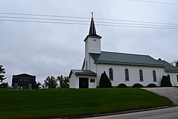
 Zion Lutheran Church in Clayton Center | |
| Coordinates: 42°53′00″N 91°19′36″W / 42.88333°N 91.32667°W | |
| Country | United States |
| State | Iowa |
| County | Clayton |
| Elevation | 988 ft (301 m) |
| Time zone | UTC-6 (Central (CST)) |
| • Summer (DST) | UTC-5 (CDT) |
| Area code | 563 |
| GNIS feature ID | 455451 |
Clayton Center is an unincorporated community located in Clayton County, Iowa, United States.
History
The area was settled as a German colony, approximately five miles east of Elkader. In April 1856, the land was surveyed by Lewis Brockman, who established the location as the "southeast quarter of section 8, township 93 north, range 3 west."[1] Clayton Center was then platted on June 27, 1857, by Fred Hartmann.[2] Clayton Center's population was 94 in 1902.[3] The population was 162 in 1940.[4]
Education
Public schools are operated by the Clayton Ridge Community School District, which formed in 2005 with the merger of the Guttenberg and Garnavillo Community School Districts.[5] Students were previously zoned to Garnavillo schools.[6]
References
- ^ History of Clayton County 1882 Archived 2015-01-04 at the Wayback Machine, Chapter XXXVIII: Read Township, page 1072-1073.
- ^ History of Clayton County, Iowa Volume 1, pages 107, 322, 492.
- ^ Cram's Modern Atlas: The New Unrivaled New Census Edition. J. R. Gray & Company. 1902. pp. 203–207.
- ^ The Attorneys List. United States Fidelity and Guaranty Company, Attorney List Department. 1940. p. 296.
- ^ "REORGANIZATION & DISSOLUTION ACTIONS SINCE 1965-66 Archived 2018-06-19 at the Wayback Machine." Iowa Department of Education. Retrieved on February 23, 2019.
- ^ "History." Garnavillo Community School District. May 29, 2000. Retrieved on February 24, 2019.


