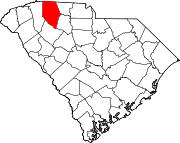
Camp Croft, South Carolina
Camp Croft, South Carolina | |
|---|---|
| Coordinates: 34°54′40″N 81°51′41″W / 34.91111°N 81.86139°W | |
| Country | United States |
| State | South Carolina |
| County | Spartanburg |
| Area | |
• Total | 2.66 sq mi (6.89 km2) |
| • Land | 2.65 sq mi (6.86 km2) |
| • Water | 0.01 sq mi (0.02 km2) |
| Elevation | 663 ft (202 m) |
| Population | |
• Total | 2,110 |
| • Density | 796.53/sq mi (307.52/km2) |
| Time zone | UTC-5 (Eastern (EST)) |
| • Summer (DST) | UTC-4 (EDT) |
| ZIP Code | 29302 (Spartanburg) |
| Area codes | 864, 821 |
| FIPS code | 45-11035 |
| GNIS feature ID | 2807092[2] |
Camp Croft is an unincorporated area and census-designated place (CDP) in Spartanburg County, South Carolina, United States. It was first listed as a CDP prior to the 2020 census.[2] The 2020 census lists a population of 2,110.[4]
The CDP is in eastern Spartanburg County and is bordered to the north by Ben Avon. South Carolina Highway 295 (Southport Road) forms the northern border of the CDP; Spartanburg is 5 miles (8 km) to the northwest, and Pacolet is 7 miles (11 km) to the east.
The Creek Golf Club is in the center of the community, and Kelsey Creek, a south-flowing tributary of Fairforest Creek and part of the Tyger River watershed, forms the southwest boundary. Croft State Park borders the community to the south.
Demographics
| Census | Pop. | Note | %± |
|---|---|---|---|
| 2020 | 2,110 | — | |
| U.S. Decennial Census[5] 2020[6][3] | |||
World War II
A U.S. Army base named Camp Croft was organized on what is now the area of the Camp Croft CDP during World War II. The base served as an Infantry Replacement Training Center and trained 60,000 soldiers per year from 1941-1946. Among the trainees was Henry Kissinger. Kissinger was naturalized at Camp Croft and would later serve as Secretary of State under President Nixon. In the later years of the war, a prisoner-of-war camp was established at Camp Croft and almost 1,000 German prisoners were held there. After the war, Camp Croft was not retained as a military installation and the land was returned to civilian control. The former base was redeveloped partly as a residential neighborhood and partly as Croft State Park.
2020 census
| Race / Ethnicity | Pop 2020[6] | % 2020 |
|---|---|---|
| White alone (NH) | 804 | 38.10% |
| Black or African American alone (NH) | 778 | 36.87% |
| Native American or Alaska Native alone (NH) | 8 | 0.38% |
| Asian alone (NH) | 304 | 14.41% |
| Pacific Islander alone (NH) | 6 | 0.28% |
| Some Other Race alone (NH) | 3 | 0.14% |
| Mixed Race/Multi-Racial (NH) | 78 | 3.70% |
| Hispanic or Latino (any race) | 129 | 6.11% |
| Total | 2,110 | 100.00% |
Note: the US Census treats Hispanic/Latino as an ethnic category. This table excludes Latinos from the racial categories and assigns them to a separate category. Hispanics/Latinos can be of any race.
References
- ^ "ArcGIS REST Services Directory". United States Census Bureau. Retrieved October 15, 2022.
- ^ a b c U.S. Geological Survey Geographic Names Information System: Camp Croft, South Carolina
- ^ a b "Census Population API". United States Census Bureau. Retrieved October 15, 2022.
- ^ "Camp Croft CDP, South Carolina". United States Census Bureau. Retrieved April 7, 2022.
- ^ "Decennial Census of Population and Housing by Decades". US Census Bureau.
- ^ a b "P2 HISPANIC OR LATINO, AND NOT HISPANIC OR LATINO BY RACE – 2020: DEC Redistricting Data (PL 94-171) – Camp Croft CDP, South Carolina". United States Census Bureau.


