Broxburn, Queensland
| Broxburn Queensland | |||||||||||||||
|---|---|---|---|---|---|---|---|---|---|---|---|---|---|---|---|
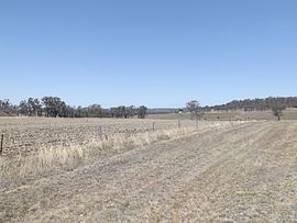
 Farms along Southbrook Road, 2014 | |||||||||||||||
| Coordinates | 27°43′54″S 151°42′14″E / 27.7316°S 151.7038°E | ||||||||||||||
| Population | 115 (2021 census)[1] | ||||||||||||||
| • Density | 3.594/km2 (9.31/sq mi) | ||||||||||||||
| Postcode(s) | 4356 | ||||||||||||||
| Area | 32.0 km2 (12.4 sq mi) | ||||||||||||||
| Time zone | AEST (UTC+10:00) | ||||||||||||||
| Location |
| ||||||||||||||
| LGA(s) | Toowoomba Region | ||||||||||||||
| State electorate(s) | Condamine | ||||||||||||||
| Federal division(s) | |||||||||||||||
| |||||||||||||||
Broxburn is a rural locality in the Toowoomba Region, Queensland, Australia.[2] In the 2021 census, Broxburn had a population of 115 people.[1]
Geography
The northwest boundary follows the Gore Highway. Close to the northern boundary is the Millmerran railway line with now-abandoned Greenhills railway station formerly serving the locality (27°40′55″S 151°41′13″E / 27.6819°S 151.6869°E).[3]
The land use is a mixture of crop growing and grazing on native vegetation.[4]
History
The Broxburn Provisional School opened on 13 June 1898. In 1909, it became Broxburn State School. It closed in 1959.[5][6] It was on the Pittsworth Felton Road (27°43′56″S 151°40′29″E / 27.7323°S 151.6746°E), now just within the boundaries of Pittsworth.[7][4]
Wilga View State School opened on 4 July 1938 and closed in 1959.[8]
Demographics
In the 2016 census Broxburn had a population of 153 people.[9]
In the 2021 census, Broxburn had a population of 115 people.[1]
Economy
There are a number of homesteads in the locality, including:[10]
- Albion Park (27°43′00″S 151°41′25″E / 27.7167°S 151.6902°E)
- Dalhiem Park (27°42′23″S 151°41′27″E / 27.7064°S 151.6909°E)
- East Lynne (27°43′00″S 151°43′10″E / 27.7166°S 151.7195°E)
- Glenhaven (27°41′32″S 151°40′52″E / 27.6923°S 151.6811°E)
- Greystones (27°41′38″S 151°42′04″E / 27.6939°S 151.7012°E)
- Helgar Park (27°41′51″S 151°41′51″E / 27.6976°S 151.6976°E)
- Highland View (27°43′00″S 151°41′36″E / 27.7166°S 151.6934°E)
- Hulilou (27°42′14″S 151°41′45″E / 27.7039°S 151.6957°E)
- Nevertire (27°42′26″S 151°41′27″E / 27.7072°S 151.6907°E)
- Peppertree (27°41′52″S 151°42′33″E / 27.6978°S 151.7093°E)
- Rockmount (27°44′04″S 151°43′11″E / 27.7344°S 151.7198°E)
- Rogar Park (27°45′05″S 151°42′01″E / 27.7515°S 151.7004°E)
- Tullawood (27°43′48″S 151°40′35″E / 27.7301°S 151.6763°E)
Education
There are no schools in Broxburn. The nearest government primary schools are Pittsworth State School in neighbouring Pittsworth to the west and Southbrook Central State School in neighbouring Southbrook to the north-east. The nearest government secondary school is Pittsworth State High School in Pittsworth.[4]
References
- ^ a b c Australian Bureau of Statistics (28 June 2022). "Broxburn (SAL)". 2021 Census QuickStats. Retrieved 28 February 2023.
- ^ "Broxburn – locality in Toowoomba Region (entry 47899)". Queensland Place Names. Queensland Government. Retrieved 29 December 2020.
- ^ "Railway stations and sidings - Queensland". Queensland Open Data. Queensland Government. 2 October 2020. Archived from the original on 5 October 2020. Retrieved 5 October 2020.
- ^ a b c "Queensland Globe". State of Queensland. Retrieved 7 April 2021.
- ^ "Opening and closing dates of Queensland Schools". Queensland Government. Retrieved 4 August 2015.
- ^ "Agency ID 5926, Broxburn State School". Queensland State Archives. Retrieved 5 August 2015.
- ^ "Parish of Rolleston, County of Aubigny" (Map). Queensland Government. 1944. Archived from the original on 7 April 2021. Retrieved 7 April 2021.
- ^ Queensland Family History Society (2010), Queensland schools past and present (Version 1.01 ed.), Queensland Family History Society, ISBN 978-1-921171-26-0
- ^ Australian Bureau of Statistics (27 June 2017). "Broxburn (SSC)". 2016 Census QuickStats. Retrieved 20 October 2018.
- ^ "Homesteads - Queensland". Queensland Open Data. Queensland Government. 18 November 2020. Archived from the original on 24 November 2020. Retrieved 24 November 2020.

