Borders of Bangladesh
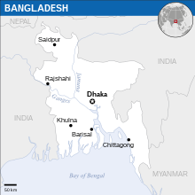
The borders of Bangladesh define the geographical boundaries of the People's Republic of Bangladesh, a South Asian country located on the Bay of Bengal. Encompassing a total length of approximately 4,427 kilometers, Bangladesh shares its borders with India to the west, north, and east, and with Myanmar to the southeast. The southern boundary is demarcated by the coastline along the Bay of Bengal. The border with India is one of the longest in the world, stretching over 4,096 kilometers, and is characterized by a complex mix of rivers, hills, and plains. The border with Myanmar, although significantly shorter at 271 kilometers, traverses through the hilly and forested regions of the Chittagong Hill Tracts. These borders have been shaped by historical treaties, colonial legacies, and geopolitical considerations, influencing the cultural and economic interactions between Bangladesh and its neighboring countries. The borders also play a crucial role in regional security, trade, and migration, making them a significant aspect of Bangladesh's national identity and international relations.

India

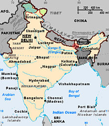
The Bangladesh–India border, known locally as the Radcliffe line (IB), is an international border running between the republics of Bangladesh and India that demarcates the six divisions of Bangladesh and the Indian states.
Bangladesh and India share a 4,096-kilometre-long (2,545 mi) international border, the fifth-longest land border in the world, including 262 km (163 mi) in Assam, 856 km (532 mi) in Tripura, 318 km (198 mi) in Mizoram, 443 km (275 mi) in Meghalaya and 2,217 km (1,378 mi) in West Bengal.[1] The Bangladeshi divisions of Mymensingh, Khulna, Rajshahi, Rangpur, Sylhet, and Chittagong are situated along the border. A number of pillars mark the border between the two states. Small demarcated portions of the border are fenced on both sides.Myanmar

The Bangladesh–Myanmar border is the international border between the countries of Bangladesh and Myanmar (formerly Burma).[2] The border stretches 271.0 kilometres (168.4 miles), from the tripoint with India in the north to the Bay of Bengal in the south.[3] About 210 km (130 mi) of the border is fenced, with the government of Myanmar announcing in 2017 that it was planning to fence off the rest of the border.[4][5]
On 9 December 2024, Arakan Army captured all of the Burmese military outposts and seized control of Myanmar's border with Bangladesh.[6]References
- ^ "Border Management: Dilemma of Guarding the India–Bangladesh Border". IDSA. January 2004.
- ^ James, Helen (2006). Security and Sustainable Development in Myanmar. Routledge. p. 120. ISBN 978-1-134-25393-7. Retrieved 11 September 2017.
- ^ "Burma". CIA World Factbook. Retrieved 17 September 2020.
- ^ "Myanmar to fence remaining border with Bangladesh". Dhaka Tribune. Retrieved 11 September 2017.
- ^ "Border fence upgrade for troubled Rakhine". Burma News International. Retrieved 11 September 2017.
- ^ "Rebel group claims to have taken control of Myanmar's border with Bangladesh in grinding civil war". CNN. Associated Press. 10 December 2024.
