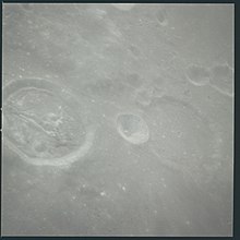
Bohnenberger (crater)
 LRO image | |
| Coordinates | 16°12′S 40°00′E / 16.2°S 40.0°E |
|---|---|
| Diameter | 33 km |
| Depth | 1.1 km |
| Colongitude | 320° at sunrise |
| Eponym | Johann von Bohnenberger |


Bohnenberger is a lunar impact crater that lies near the east edge of the Mare Nectaris, in the foothills of the Montes Pyrenaeus mountain range that forms the perimeter of the mare. To the east beyond the mountains is the larger crater Colombo. The crater has a low rim along the north wall, and the floor is somewhat irregular with a ridge crossing the floor. There is a small crater along the western inner wall.
The name of the crater was approved by the IAU in 1935 and refers to German astronomer Johann von Bohnenberger.[1]
Satellite craters
By convention these features are identified on lunar maps by placing the letter on the side of the crater midpoint that is closest to Bohnenberger.
| Bohnenberger | Latitude | Longitude | Diameter |
|---|---|---|---|
| A | 17.8° S | 40.1° E | 30 km |
| C | 18.5° S | 41.1° E | 16 km |
| D | 18.3° S | 42.6° E | 14 km |
| E | 17.4° S | 42.1° E | 13 km |
| F | 14.7° S | 39.6° E | 10 km |
| G | 17.2° S | 40.1° E | 12 km |
| J | 14.8° S | 40.3° E | 5 km |
| N | 17.9° S | 41.9° E | 6 km |
| P | 19.1° S | 41.4° E | 11 km |
| W | 18.2° S | 41.1° E | 10 km |
References
- ^ Bohnenberger, Gazetteer of Planetary Nomenclature, International Astronomical Union (IAU) Working Group for Planetary System Nomenclature (WGPSN)
- Andersson, L. E.; Whitaker, E. A. (1982). NASA Catalogue of Lunar Nomenclature. NASA RP-1097.
- Bussey, B.; Spudis, P. (2004). The Clementine Atlas of the Moon. New York: Cambridge University Press. ISBN 978-0-521-81528-4.
- Cocks, Elijah E.; Cocks, Josiah C. (1995). Who's Who on the Moon: A Biographical Dictionary of Lunar Nomenclature. Tudor Publishers. ISBN 978-0-936389-27-1.
- McDowell, Jonathan (July 15, 2007). "Lunar Nomenclature". Jonathan's Space Report. Retrieved 2007-10-24.
- Menzel, D. H.; Minnaert, M.; Levin, B.; Dollfus, A.; Bell, B. (1971). "Report on Lunar Nomenclature by the Working Group of Commission 17 of the IAU". Space Science Reviews. 12 (2): 136–186. Bibcode:1971SSRv...12..136M. doi:10.1007/BF00171763. S2CID 122125855.
- Moore, Patrick (2001). On the Moon. Sterling Publishing Co. ISBN 978-0-304-35469-6.
- Price, Fred W. (1988). The Moon Observer's Handbook. Cambridge University Press. ISBN 978-0-521-33500-3.
- Rükl, Antonín (1990). Atlas of the Moon. Kalmbach Books. ISBN 978-0-913135-17-4.
- Webb, Rev. T. W. (1962). Celestial Objects for Common Telescopes (6th revised ed.). Dover. ISBN 978-0-486-20917-3.
- Whitaker, Ewen A. (1999). Mapping and Naming the Moon. Cambridge University Press. ISBN 978-0-521-62248-6.
- Wlasuk, Peter T. (2000). Observing the Moon. Springer. ISBN 978-1-85233-193-1.
External links
![]() Media related to Bohnenberger (crater) at Wikimedia Commons
Media related to Bohnenberger (crater) at Wikimedia Commons

