Blackburn with Darwen
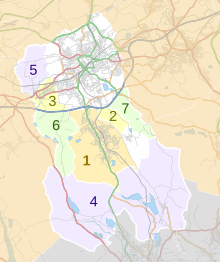
Blackburn with Darwen is a unitary authority area with borough status in the ceremonial county of Lancashire, North West England. The borough includes the towns of Blackburn and Darwen plus a wider rural area which includes the villages of Lower Darwen, Feniscowles, Brownhill and Hoddlesden.[5]
Formation
It was founded in 1974 as the Lancashire borough of Blackburn, from the County Borough of Blackburn, the Municipal Borough of Darwen, the parish of North Turton from Turton Urban District (chiefly the villages of Belmont, Chapeltown and Edgworth) and parts of Blackburn Rural District. It was renamed in May 1997, in preparation for a split from Lancashire County Council. On 1 April 1998 it became a unitary authority.
Demographics
Ethnicity
| Ethnic group | School year | |
|---|---|---|
| 2021/2022 | ||
| Number | % | |
| White: Total | 12,911 | 46.1 |
| White: British | 11,876 | 42.4 |
| White: Irish | 28 | 0.1 |
| White: Traveller of Irish heritage | 25 | 0.1 |
| White: Gypsy/Roma | 21 | 0.1 |
| White: Other | 961 | 3.4 |
| Asian / Asian British: Total | 12,835 | 45.8 |
| Asian / Asian British: Indian | 4,592 | 16.4 |
| Asian / Asian British: Pakistani | 7,282 | 26.0 |
| Asian / Asian British: Bangladeshi | 290 | 1.0 |
| Asian / Asian British: Chinese | 71 | 0.3 |
| Asian / Asian British: Other Asians | 600 | 2.1 |
| Black / Black British: Total | 344 | 1.2 |
| Black: Caribbean | 13 | 0.0 |
| Black: African | 274 | 1.0 |
| Black: Other Blacks | 57 | 0.2 |
| Mixed / British Mixed | 1,129 | 4 |
| Other: Total | 474 | 1.7 |
| Unclassified | 290 | 1.0 |
| Total: | 27,983 | 100.0 |
Religion
According to the 2021 census, 38.0% of the population was Christian, 35.0% Muslim, 0.3% Hindu, 0.2% Buddhist, 0.4% followed another religions (including Judaism, Sikhism and others), 21.1% were not affiliated to a religion and 5.0% did not state their religious views.
Religion in Blackburn with Darwen as of 2021 [7]
Governance
The council is based at Blackburn Town Hall on King William Street in the centre of Blackburn. As a unitary authority, Blackburn with Darwen Borough Council provides most local government services. Parts of the borough are covered by civil parishes, which provide a lower tier of local government.
Economy
This is a chart of trend of regional gross value added of Blackburn with Darwen at current basic prices published Archived 22 August 2006 at the Wayback Machine (pp. 240–253) by Office for National Statistics with figures in millions of British Pounds Sterling.
| Year | Regional Gross Value Added[a] | Agriculture[b] | Industry[c] | Services[d] |
|---|---|---|---|---|
| 1995 | 1,496 | 3 | 755 | 737 |
| 2000 | 1,597 | 3 | 678 | 916 |
| 2003 | 1,785 | 4 | 647 | 1,134 |
Settlements
Civil parishes

The town of Blackburn and the village of Hoddlesden lie in unparished areas.
Education
As a unitary authority, Blackburn with Darwen authority has a statutory responsibility for educational standards and schooling within its boundaries.[8]
Transport
Blackburn with Darwen Council has a stated transport policy of "making roads traffic free".[9]
Freedom of the Borough
The following people and military units have received the Freedom of the Borough of Blackburn with Darwen.[10]
Individuals
- Barbara Castle: 23 November 1979.
- Sir Charles Fletcher-Cooke: 23 November 1979.
- Tom Taylor, Baron Taylor of Blackburn: 2 April 1992.
- Jack Straw: 1 October 2015.[11]
Military Units
- The East Lancashire Regiment: 5 February 1948.
- The Lancashire Regiment: 6 November 1958.
- The Queen's Lancashire Regiment: 25 March 1970.
- The Duke of Lancaster's Regiment: 1 July 2006.
See also
Notes
References
- ^ "Council and democracy". Blackburn with Darwen Borough Council. Retrieved 22 January 2024.
- ^ "Mid-Year Population Estimates, UK, June 2022". Office for National Statistics. 26 March 2024. Retrieved 3 May 2024.
- ^ "Mid-Year Population Estimates, UK, June 2022". Office for National Statistics. 26 March 2024. Retrieved 3 May 2024.
- ^ a b UK Census (2021). "2021 Census Area Profile – Blackburn with Darwen Local Authority (E06000008)". Nomis. Office for National Statistics. Retrieved 22 January 2024.
- ^ "Unitary Authority population 2011". Archived from the original on 4 March 2016. Retrieved 15 January 2016.
- ^ "Schools, pupils and their characteristics, Academic Year 2021/22". explore-education-statistics.service.gov.uk. Retrieved 28 November 2022.
- ^ "Religion". Office for National Statistics. Retrieved 7 December 2022.
- ^ "Types of Council". Archived from the original on 26 January 2013. Retrieved 6 January 2013.
- ^ Blackburn with Darwen Council. "Transport & streets policies & strategies". Archived from the original on 11 June 2017. Retrieved 27 May 2017.
- ^ "Freedom of the Borough". Blackburn with Darwen Borough Council. Retrieved 17 January 2022.
- ^ Jacobs, Bill (25 September 2015). "Former Blackburn MP Jack Straw to be given 'freedom' of the borough". The Lancashire Telegraph. Retrieved 17 January 2022.


