Benešov District
Benešov District Okres Benešov | |
|---|---|
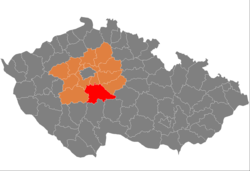
 Location in the Central Bohemian Region within the Czech Republic | |
| Coordinates: 49°44′N 14°45′E / 49.733°N 14.750°E | |
| Country | |
| Region | Central Bohemian |
| Capital | Benešov |
| Area | |
• Total | 1,474.91 km2 (569.47 sq mi) |
| Population (2024)[2] | |
• Total | 103,359 |
| • Density | 70/km2 (180/sq mi) |
| Time zone | UTC+1 (CET) |
| • Summer (DST) | UTC+2 (CEST) |
| Municipalities | 114 |
| * Towns | 10 |
| * Market towns | 11 |
Benešov District (Czech: okres Benešov) is a district in the Central Bohemian Region of the Czech Republic. Its capital is the town of Benešov.
Administrative division
Benešov District is divided into three administrative districts of municipalities with extended competence: Benešov, Vlašim and Votice.
List of municipalities
Towns are marked in bold and market towns in italics:
Benešov – Bernartice – Bílkovice – Blažejovice – Borovnice – Bukovany – Bystřice – Čakov – Čechtice – Čerčany – Červený Újezd – Český Šternberk – Chářovice – Chleby – Chlístov – Chlum – Chmelná – Chocerady – Choratice – Chotýšany – Chrášťany – Ctiboř – Čtyřkoly – Děkanovice – Divišov – Dolní Kralovice – Drahňovice – Dunice – Heřmaničky – Hradiště – Hulice – Hvězdonice – Jankov – Javorník – Ješetice – Jinošice – Kamberk – Keblov – Kladruby – Kondrac – Kozmice – Křečovice – Krhanice – Křivsoudov – Krňany – Kuňovice – Lešany – Libež – Litichovice – Loket – Louňovice pod Blaníkem – Lštění – Maršovice – Mezno – Miličín – Miřetice – Mnichovice – Mrač – Načeradec – Nespeky – Netvořice – Neustupov – Neveklov – Olbramovice – Ostrov – Ostředek – Pavlovice – Petroupim – Popovice – Poříčí nad Sázavou – Postupice – Pravonín – Přestavlky u Čerčan – Psáře – Pyšely – Rabyně – Radošovice – Rataje – Ratměřice – Řehenice – Řimovice – Sázava – Šetějovice – Slověnice – Smilkov – Snět – Soběhrdy – Soutice – Stranný – Strojetice – Střezimíř – Struhařov – Studený – Tehov – Teplýšovice – Tichonice – Tisem – Tomice – Třebešice – Trhový Štěpánov – Týnec nad Sázavou – Václavice – Veliš – Vlašim – Vodslivy – Vojkov – Votice – Vracovice – Vranov – Vrchotovy Janovice – Všechlapy – Vysoký Újezd – Xaverov – Zdislavice – Zvěstov
Geography

A rugged and hilly landscape is typical for the district. The territory extends into three geomorphological mesoregions: Benešov Uplands (north), Vlašim Uplands (south) and Křemešník Highlands (smaller part in the east). The highest point of the district is the Mezivrata hill in Neustupov with an elevation of 713 m (2,339 ft), the lowest point is the Štěchovice Reservoir in Krňany at 220 m (720 ft).
The area is rich in watercourses and ponds. The most important river is the Sázava, which forms the north and northeast boundary of the district before crossing it on the northwest. Other important rivers of the district area its tributaries Blanice and Želivka. Slapy and Štěchovice reservoirs, built on the Vltava River, form the western boundary of the district. The largest body of water is Švihov Reservoir, built on the Želivka. It is the fourth largest reservoir in the country.
From the total district area of 1,474.9 km2 (569.5 sq mi), agricultural land occupies 903.0 km2 (348.7 sq mi), forests occupy 414.5 km2 (160.0 sq mi), and water area occupies 33.6 km2 (13.0 sq mi). Forests cover 28.1% of the district's area.[1]
Blaník is the only protected landscape area in the district, covering the surrounding area of the eponymous mountain.
Demographics
|
|
| ||||||||||||||||||||||||||||||||||||||||||||||||||||||
| Source: Censuses[3][4] | ||||||||||||||||||||||||||||||||||||||||||||||||||||||||
Most populated municipalities
| Name | Population[2] | Area (km2) |
|---|---|---|
| Benešov | 17,035 | 47 |
| Vlašim | 11,455 | 41 |
| Týnec nad Sázavou | 5,717 | 26 |
| Votice | 4,688 | 36 |
| Bystřice | 4,686 | 63 |
| Sázava | 3,875 | 20 |
| Čerčany | 3,134 | 6 |
| Neveklov | 2,769 | 54 |
| Pyšely | 2,230 | 13 |
| Divišov | 1,810 | 31 |
Economy
The largest employers with headquarters in Benešov District and at least 500 employees are:[5]
| Economic entity | Location | Number of employees | Main activity |
|---|---|---|---|
| Sellier & Bellot | Vlašim | 1,500–1,999 | Manufacture of ammunition |
| Benešov Hospital | Benešov | 1,000–1,499 | Health care |
| RABBIT | Trhový Štěpánov | 500–999 | Food industry |
Transport
The D1 motorway from Prague to Brno passes through the northern and eastern part of the district. The European route E55 separates from it, which passes across the district and continues as D3 motorway in its south.
Sights

The most important monuments in the district, protected as national cultural monuments, are:[6]
The best-preserved settlement, which is the only one protected as a monument zone, is Načeradec.[7]
The most visited tourist destination is the Konopiště Castle.[8]
Notable people
References
- ^ a b "Land use (as at 31 December)". Public database. Czech Statistical Office. Retrieved 2023-05-16.
- ^ a b "Population of Municipalities – 1 January 2024". Czech Statistical Office. 2024-05-17.
- ^ "Historický lexikon obcí České republiky 1869–2011" (in Czech). Czech Statistical Office. 2015-12-21.
- ^ "Population Census 2021: Population by sex". Public Database. Czech Statistical Office. 2021-03-27.
- ^ "Registr ekonomických subjektů". Business Register (in Czech). Czech Statistical Office. Retrieved 2023-01-17.
- ^ "Výsledky vyhledávání: Národní kulturní památky, okres Benešov". Ústřední seznam kulturních památek (in Czech). National Heritage Institute. Retrieved 2024-06-19.
- ^ "Výsledky vyhledávání: Památkové rezervace, Památkové zóny, okres Benešov". Ústřední seznam kulturních památek (in Czech). National Heritage Institute. Retrieved 2024-06-19.
- ^ "Návštěvnost památek 2023" (in Czech). Národní informační a poradenské středisko pro kulturu. Retrieved 2024-06-19.
External links
- Benešov District profile on the Czech Statistical Office's website
