Bandar Springhill
Bandar Springhill | |
|---|---|
Suburb of Port Dickson | |
| Other transcription(s) | |
| • Jawi | بندر سڤريڠهيل |
| • Chinese | 春泉镇 |
| • Tamil | பந்தர் ஸ்பிரிங்ஹில் |
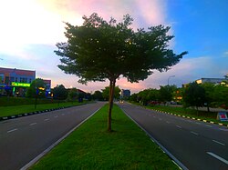
 Persiaran Springhill, the main thoroughfare of the township | |
 Location of Bandar Springhill in Negeri Sembilan | |
| Country | Malaysia |
| State | Negeri Sembilan |
| District | Port Dickson |
| Luak | Sungai Ujong |
| Established | 1997 |
| Government | |
| • Local authority | Port Dickson Municipal Council |
| Elevation | 25 m (82 ft) |
| Time zone | UTC+8 (Malaysia Standard Time) |
| • Summer (DST) | Not applicable |
| Postcode | 71010 |
| Website | https://bandarspringhill.com/ |
Bandar Springhill (Jawi: بندر سڤريڠهيل; Chinese: 春泉镇) is a planned township in Port Dickson District, Negeri Sembilan, Malaysia. A suburb of Port Dickson, the township is located near Lukut, and also adjacent to Bandar Sri Sendayan in neighbouring Seremban District.
Development


Bandar Springhill was first conceived in July 1997. [1] It is a part of the Malaysia Vision Valley (MVV) growth corridor that spans both Seremban and Port Dickson districts in western Negeri Sembilan. [2]
West Synergy Sdn Bhd, a 60-40 joint-venture between the MUI Group through its property arm, MUI Properties Berhad[3]and Chin Teck Plantations Berhad planned out to develop the 2,000-acre (8.1 km2) freehold land into the following components:[4]
- E1S (future residential development)
- E2
- 2 Residences
- Springhill Commercial Centre
- E3A (Amarilis)
- Park Residences
- E4
- Olive & Maple
- Future commercial development
- Lakefront Commercial (future commercial development)
- E5 (Nebula)
- E6 (Aurora & Nova)
- E7
- Residence 7
- E7-1 (Peony & Freesia)
- E7-2 (Irises & Cosmos)
- E8 (Cempaka)
- E9
- Meranti Residences
- The Junction
- E10
- 10 North Residences
- 10 South Residences
- 10 Avenue Square
- E10S (Astral)
- E11 (Springhill Heights)
- E12 (future residential development)
- Springhill Industrial Park
- SIP1
- SIP2
- SIP3
- W1 (future industrial development)
- W2
- W3
- Ortus (joint venture between SCLand and West Synergy)[5]
- UCSI Health Metropolis [6]
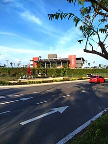
- UCSI University and Hospital
- UCSI International School [7]
Infrastructures
Transportation

Bandar Springhill is accessible from both Seremban and Port Dickson via Malaysia Federal Route 53 and the Seremban-Port Dickson Highway.
Healthcare

In terms of healthcare, Bandar Springhill is currently served by two polyclinics and the larger UCSI Hospital at the opposite side of the Seremban-Port Dickson Highway, of which it is linked by an overpass.
Education


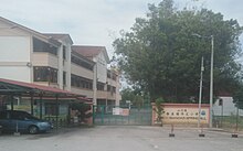
A number of educational institutions, ranging from preschool to tertiary, are also present in Bandar Springhill and its vicinities, such as the UCSI University (also integrated with the hospital), UCSI International School, Sekolah Jenis Kebangsaan (C) Bandar Springhill and Sekolah Jenis Kebangsaan (T) Bandar Springhill, as well as Sekolah Kebangsaan Lukut and Sekolah Menengah Kebangsaan Yam Tuan Radin outside of the township.
Other amenities
References
- ^ "About Us". Bandar Springhill. Retrieved 5 July 2024.
- ^ "Malaysia Vision Valley". Bandar Springhill. Retrieved 5 July 2024.
- ^ "Home". The MUI Group. Retrieved 10 July 2024.
- ^ "Projects". Bandar Springhill. Retrieved 5 July 2024.
- ^ "Ortus Park". SCLand. Retrieved 5 July 2024.
- ^ "Redefining Healthcare at UCSI University". UCSI University. Retrieved 5 July 2024.
- ^ "Home". UCSI International School. Retrieved 5 July 2024.
External links
- Website : www.bandarspringhill.com
- Facebook : www.facebook.com/bandarspringhillseremban
- Instagram : www.instagram.com/bandarspringhill
