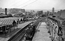
Bakewell railway station
Bakewell | |
|---|---|
 The station in 1905 | |
| General information | |
| Location | Bakewell, Derbyshire Dales England |
| Coordinates | 53°13′04″N 1°40′08″W / 53.2177°N 1.6689°W |
| Platforms | 2 |
| Other information | |
| Status | Disused |
| History | |
| Original company | Midland Railway |
| Pre-grouping | Midland Railway |
| Post-grouping | London Midland and Scottish Railway |
| Key dates | |
| 1 August 1862 | Station opened |
| 6 March 1967 | Station closed[1] |
Listed Building – Grade II | |
| Feature | Former Bakewell railway station |
| Designated | 28 January 1994 |
| Reference no. | 1316505[2] |
Bakewell railway station served the town of Bakewell in Derbyshire, England. It was built by the Midland Railway on its extension of the Manchester, Buxton, Matlock and Midland Junction Railway line from Rowsley to Buxton. The station was closed in 1967. Peak Rail Heritage Railway intends to reopen the station to trains by extending its existing Matlock to Rowsley South line 4 miles through Rowsley to Bakewell.[3]
History


The station was opened by the Midland Railway on 1 August 1862.[1] Being the nearest station to Haddon Hall, it was built in a grand style as the local station for the Duke of Rutland over whose land the line had passed. Designed by Edward Walters of Manchester, the buildings were of fine ashlar with intricate carvings which incorporated the duke's coat of arms.
Since the line climbed steeply towards its summit at Peak Forest, the station was located uphill about half a mile from the town, which became a disadvantage when road transport developed.
It was used most frequently during the Bakewell Show, but the station was also popular with campers and tourists. The station was host to a London, Midland and Scottish Railway camping coach from 1935 to 1939; one was also positioned here by the London Midland Region from 1954 to 1967.[4][5]
Following the grouping of all lines into four main companies in 1923, the station became part of the London, Midland and Scottish Railway.
During the nationalisation of Britain's railways in 1948, the station was passed on to the London Midland Region of British Railways and, despite escaping the Beeching Axe, the station was closed when passenger services ceased on 6 March 1967.[1] Trains continued to pass through the station until 1968 when the line was closed.
| Preceding station | Disused railways | Following station | ||
|---|---|---|---|---|
| Rowsley Line and station closed |
Midland Railway Manchester, Buxton, Matlock and Midland Junction Railway |
Hassop Line and station closed | ||
| Rowsley | Peak Rail | Terminus | ||
The site today
Monsal Trail | |||||||||||||||||||||||||||||||||||||||||||||||||||||||||||||||||||||||||||||||||||||||||||||||||||||||||||||||||||||||||||||||||||||||||||||||||||||||||||
|---|---|---|---|---|---|---|---|---|---|---|---|---|---|---|---|---|---|---|---|---|---|---|---|---|---|---|---|---|---|---|---|---|---|---|---|---|---|---|---|---|---|---|---|---|---|---|---|---|---|---|---|---|---|---|---|---|---|---|---|---|---|---|---|---|---|---|---|---|---|---|---|---|---|---|---|---|---|---|---|---|---|---|---|---|---|---|---|---|---|---|---|---|---|---|---|---|---|---|---|---|---|---|---|---|---|---|---|---|---|---|---|---|---|---|---|---|---|---|---|---|---|---|---|---|---|---|---|---|---|---|---|---|---|---|---|---|---|---|---|---|---|---|---|---|---|---|---|---|---|---|---|---|---|---|---|
| |||||||||||||||||||||||||||||||||||||||||||||||||||||||||||||||||||||||||||||||||||||||||||||||||||||||||||||||||||||||||||||||||||||||||||||||||||||||||||
| Sources[6][7] | |||||||||||||||||||||||||||||||||||||||||||||||||||||||||||||||||||||||||||||||||||||||||||||||||||||||||||||||||||||||||||||||||||||||||||||||||||||||||||
The station buildings still survive and are Grade II listed.[2] They are sited half a mile east of the centre of Bakewell, high upon the hillside due to the alignment that the railway was forced to take.
The main building is now used by an electronics company, which has retained many of the station's original features; the goods shed is now part of an industrial estate. The gap between the platforms has been filled in, as the Monsal Trail shared-use path now passes through the site along the former trackbed.[8]
The ridged canopies over platform 1, the goods shed and cattle dock have all since been removed.
See also
References
Citations
- ^ a b c Butt 1995, p. 23
- ^ a b Historic England. "Former Bakewell Railway Station (Grade II) (1316505)". National Heritage List for England. Retrieved 26 March 2019.
- ^ "Our reinstatement proposals for the Peaks and Dales Railway". Peaks and Dales Railway Limited. Retrieved 28 September 2024.
- ^ Kingscott, Geoffrey (2007). Lost Railways of Derbyshire. Newbury: Countryside Books. ISBN 9781846740428.
- ^ McRae 1997, pages 22 & 50
- ^ "The Monsal Trail". A Taste of the Peak District. Retrieved 10 April 2020.
- ^ Bickerdike, Graeme (June 2009). "The story of structures of the Monsal Trail: A Week in the Peak". Retrieved 10 April 2020.
- ^ Wright, Paul (4 June 2017). "Station name: Bakewell". Disused Stations. Retrieved 13 September 2024.
Bibliography
- Butt, R. V. J. (October 1995). The Directory of Railway Stations: details every public and private passenger station, halt, platform and stopping place, past and present (1st ed.). Sparkford: Patrick Stephens Ltd. ISBN 978-1-85260-508-7. OCLC 60251199. OL 11956311M.
- McRae, Andrew (1997). British Railway Camping Coach Holidays: The 1930s & British Railways (London Midland Region). Vol. Scenes from the Past: 30 (Part One). Foxline. ISBN 1-870119-48-7.
Further reading
- Jowett, Alan (2000). Jowett's Nationalised Railway Atlas (1st ed.). Penryn, Cornwall: Atlantic Transport Publishers. ISBN 978-0-906899-99-1. OCLC 228266687.
- Jowett, Alan (March 1989). Jowett's Railway Atlas of Great Britain and Ireland: From Pre-Grouping to the Present Day (1st ed.). Sparkford: Patrick Stephens Ltd. ISBN 978-1-85260-086-0. OCLC 22311137.
- Station on navigable O.S. map
- Truman, P.; Hunt, D. (1989). Midland Railway Portrait. Sheffield: Platform 5 Publishing. ISBN 0906579724.
- Radford, B. (1988). Midland Through the Peak: A Pictorial History of the Midland Railway Main Line Routes Between Derby and Manchester. Unicorn Books. ISBN 1852410019.
