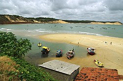
Baía Formosa
Baía Formosa | |
|---|---|
Municipality | |
| The Municipality of Baía Formosa | |
 Praia do Porto | |
 Location of Baía Formosa | |
| Coordinates: 06°22′08″S 35°00′28″W / 6.36889°S 35.00778°W | |
| Country | |
| Region | Northeast |
| State | |
| Founded | December 31, 1958 |
| Government | |
| • Mayor | José Nivaldo Araújo de Melo |
| Area | |
• Total | 245.510 km2 (94.792 sq mi) |
| Population (2020 [1]) | |
• Total | 9,322 |
| • Density | 33.7/km2 (87/sq mi) |
| Time zone | UTC−3 (BRT) |
| HDI (2000) | 0.643 – medium[2] |
Baía Formosa (lit. "beautiful bay") is the easternmost city in the Brazilian state of Rio Grande do Norte and the first coastal city (going south–north) of that state, lying near the border with Paraíba.
The municipality contains the 7,897-hectare (19,510-acre) Mata da Estrela Private Natural Heritage Reserve.[3]
Notable people
- Ítalo Ferreira, world champion surfer[4]
References
- ^ IBGE 2020
- ^ "Archived copy". Archived from the original on 2009-10-03. Retrieved 2009-12-17.
{{cite web}}: CS1 maint: archived copy as title (link) - UNDP - ^ RPPN Mata Estrela (in Portuguese), ICMBio, retrieved 2016-05-18
- ^ "Cidade natal de Italo Ferreira, Baía Formosa comemora ouro no surfe nas Olimpíadas de Tóquio".


