Arthur's Pass
Arthur's Pass | |
|---|---|
Township | |
 Arthur's Pass township | |
 | |
| Coordinates: 42°56′43.4″S 171°33′56.4″E / 42.945389°S 171.565667°E | |
| Country | New Zealand |
| Region | Canterbury |
| District | Selwyn |
| Ward | Malvern |
| Community | Malvern |
| Founded | 1906 (originally named Bealey Flat) |
| Electorates |
|
| Government | |
| • Territorial authority | Selwyn District Council |
| • Regional council | Environment Canterbury |
| • Mayor of Selwyn | Sam Broughton |
| • Selwyn MP | Nicola Grigg |
| • Te Tai Tonga MP | Tākuta Ferris |
| Area | |
• Total | 0.27 km2 (0.10 sq mi) |
| Elevation | 739 m (2,425 ft) |
| Population (June 2024)[2] | |
• Total | 40 |
| • Density | 150/km2 (380/sq mi) |
| Time zone | UTC+12 (NZST) |
| • Summer (DST) | UTC+13 (NZDT) |
| Postcode | 7654 |
| Area code | 03 |
| Local iwi | Ngāi Tahu |
Arthur's Pass, previously called Camping Flat then Bealey Flats, and for some time officially Arthurs Pass, is a township in the Southern Alps of the South Island of New Zealand, located in the Selwyn district. It is a popular base for exploring Arthur's Pass National Park.
Arthur's Pass township is about five kilometres (3.1 mi) south of the mountain pass with the same name. At an elevation of 740 metres (2,430 ft) above sea level, the settlement is surrounded by beech forest. The Bealey River runs through the township. The town is located 153 kilometres (95 mi) from Christchurch, a two-hour drive on State Highway 73.
Naming and history
The township and the pass take their names after Arthur Dudley Dobson (1841–1934, Sir Arthur from 1931). The Chief Surveyor of Canterbury Province, Thomas Cass, had tasked Arthur Dobson to find out if there was an available pass out of the Waimakariri watershed into valleys running to the West Coast. In 1864 Arthur's brother Edward Henry Dobson joined him and accompanied him over the watershed into the valley of the Ōtira River. A West Coast Māori chief, Tarapuhi, told Arthur of a pass that Māori hunting-parties occasionally used. When Arthur returned to Christchurch, he sketched the country he had traversed and included it in a report to Cass. Arthur Dobson did not name the pass, which he found very steep on the western side.[3] Dobson gave the name "Camping Flat" to the site that became the township.
When the West Coast gold rush began in 1864, a committee of businessmen offered a £200 prize for anyone who would find a better or more suitable pass from Canterbury over the Southern Alps to West Canterbury (the West Coast). At the same time George Dobson, (another brother), was sent to examine every available pass between the watershed of the Taramakau, Waimakariri, and the Hurunui. After examining passes at the head of every valley he reported that "Arthur's" pass was by far the most suitable for the direct crossing.[4]
The township, at the time named Bealey Flats after the second Superintendent of Canterbury, Samuel Bealey, was originally built as a construction village for the building of the Otira Tunnel, which started on 14 January 1908.[5] The railway from Christchurch reached Arthur's Pass township in 1914, the Westland section having advanced to Otira. Construction of the tunnel was very slow; it finally finished in 1923, and its opening marked by the British and Intercolonial Exhibition.[6] The TranzAlpine passenger rail service passes through Arthur's Pass and the Otira Tunnel as part of its 223 kilometres (139 mi) journey from Christchurch to Greymouth. The trip is considered[by whom?] one of the world's great train journeys due to its scenery and views.
A power station was built[when?] below the Devil's Punchbowl Falls to provide electricity for the tunnel construction and for the village itself.
In 1929, the Arthur's Pass National Park was established[by whom?], New Zealand's third national park.[7][8] An earthquake measuring 7.1 struck Arthurs Pass on 9 March 1929. Slips closed the road to the west coast for months and there was damage to the railway lines. The earthquake was thought to have occurred due to movement along the Poulter Fault.[9]
The Geographic Board had a policy of omitting apostrophes in place names, and the name was officially changed[when?] to "Arthurs Pass". This caused an upset with the local population, and the Minister of Lands reinstated the old version with the apostrophe. On 16 September 1975 the New Zealand Post Office also adopted the spelling with the apostrophe.[7][failed verification]
Demographics
Arthur's Pass is described by Statistics New Zealand as a rural settlement, and covers 0.27 km2 (0.10 sq mi).[1] It had an estimated population of 40 as of June 2024,[2] with a population density of 148 people per km2. It is part of the statistical area of Craigieburn.[10]
| Year | Pop. | ±% p.a. |
|---|---|---|
| 2006 | 75 | — |
| 2013 | 54 | −4.58% |
| 2018 | 48 | −2.33% |
| Source: [11] | ||
Arthur's Pass had a population of 48 at the 2018 New Zealand census, a decrease of 6 people (−11.1%) since the 2013 census, and a decrease of 27 people (−36.0%) since the 2006 census. There were 30 households, comprising 27 males and 21 females, giving a sex ratio of 1.29 males per female. The median age was 44.0 years (compared with 37.4 years nationally), with 3 people (6.2%) aged under 15 years, 9 (18.8%) aged 15 to 29, 30 (62.5%) aged 30 to 64, and 3 (6.2%) aged 65 or older.
Ethnicities were 81.2% European/Pākehā, 6.2% Pasifika, and 18.8% Asian. People may identify with more than one ethnicity.
Although some people chose not to answer the census's question about religious affiliation, 56.2% had no religion, 31.2% were Christian and 6.2% had other religions.
Of those at least 15 years old, 24 (53.3%) people had a bachelor's or higher degree, and 3 (6.7%) people had no formal qualifications. The median income was $36,600, compared with $31,800 nationally. 9 people (20.0%) earned over $70,000 compared to 17.2% nationally. The employment status of those at least 15 was that 30 (66.7%) people were employed full-time, 9 (20.0%) were part-time, and 3 (6.7%) were unemployed.[11]
Climate
Arthur's Pass township lies in a valley about 750 metres above sea level and is about 4 km south of Arthur's Pass (920 m). The town falls under the Köppen-Geiger climate classification of Cfb (Oceanic). Snowfall is not uncommon during winter, especially in the mountains above the village. The coldest temperature recorded in Arthurs Pass was −18.9 °C (−2 °F) at Bealey on 19 July 1878. [12]
| Climate data for Arthurs Pass Village (1991–2020 normals, extremes 1978–present) | |||||||||||||
|---|---|---|---|---|---|---|---|---|---|---|---|---|---|
| Month | Jan | Feb | Mar | Apr | May | Jun | Jul | Aug | Sep | Oct | Nov | Dec | Year |
| Record high °C (°F) | 32.1 (89.8) |
29.5 (85.1) |
26.4 (79.5) |
22.5 (72.5) |
17.6 (63.7) |
14.0 (57.2) |
12.8 (55.0) |
14.3 (57.7) |
20.0 (68.0) |
22.5 (72.5) |
26.2 (79.2) |
27.6 (81.7) |
32.1 (89.8) |
| Mean maximum °C (°F) | 25.6 (78.1) |
25.4 (77.7) |
22.4 (72.3) |
17.8 (64.0) |
14.4 (57.9) |
11.1 (52.0) |
9.9 (49.8) |
12.0 (53.6) |
14.9 (58.8) |
18.0 (64.4) |
20.7 (69.3) |
23.4 (74.1) |
27.2 (81.0) |
| Mean daily maximum °C (°F) | 18.3 (64.9) |
18.6 (65.5) |
16.1 (61.0) |
12.7 (54.9) |
9.7 (49.5) |
6.7 (44.1) |
6.0 (42.8) |
7.6 (45.7) |
9.8 (49.6) |
11.7 (53.1) |
13.9 (57.0) |
16.5 (61.7) |
12.3 (54.2) |
| Daily mean °C (°F) | 13.3 (55.9) |
13.4 (56.1) |
11.2 (52.2) |
8.3 (46.9) |
5.8 (42.4) |
3.0 (37.4) |
2.2 (36.0) |
3.5 (38.3) |
5.5 (41.9) |
7.3 (45.1) |
9.3 (48.7) |
11.8 (53.2) |
7.9 (46.2) |
| Mean daily minimum °C (°F) | 8.3 (46.9) |
8.2 (46.8) |
6.3 (43.3) |
4.0 (39.2) |
1.9 (35.4) |
−0.6 (30.9) |
−1.6 (29.1) |
−0.7 (30.7) |
1.3 (34.3) |
3.0 (37.4) |
4.7 (40.5) |
7.2 (45.0) |
3.5 (38.3) |
| Mean minimum °C (°F) | 2.5 (36.5) |
2.3 (36.1) |
−0.4 (31.3) |
−2.2 (28.0) |
−3.9 (25.0) |
−6.7 (19.9) |
−7.5 (18.5) |
−6.2 (20.8) |
−4.5 (23.9) |
−2.7 (27.1) |
−1.4 (29.5) |
1.3 (34.3) |
−8.3 (17.1) |
| Record low °C (°F) | −1.0 (30.2) |
−1.5 (29.3) |
−8.5 (16.7) |
−7.8 (18.0) |
−7.5 (18.5) |
−11.5 (11.3) |
−12.5 (9.5) |
−11.0 (12.2) |
−8.2 (17.2) |
−6.1 (21.0) |
−5.0 (23.0) |
−1.4 (29.5) |
−12.5 (9.5) |
| Average rainfall mm (inches) | 413.5 (16.28) |
272.6 (10.73) |
321.2 (12.65) |
370.3 (14.58) |
395.0 (15.55) |
378.1 (14.89) |
328.4 (12.93) |
353.0 (13.90) |
452.5 (17.81) |
489.4 (19.27) |
438.6 (17.27) |
447.7 (17.63) |
4,660.3 (183.49) |
| Average relative humidity (%) | 77 | 78 | 82 | 86 | 88 | 90 | 88 | 87 | 84 | 81 | 78 | 78 | 83 |
| Source 1: NIWA [13] | |||||||||||||
| Source 2: "Arthur's Pass - Weather Database"[14] | |||||||||||||
Facilities and attractions

New Zealand's first national park visitor centre was built in Arthur's Pass in 1959, with the help of the Christchurch Wanderers Tramping Club. It was designed by Christchurch architect Paul Pascoe and used local stone to reflect the geology of the national park.[15] As well as Department of Conservation offices, the building housed museum displays on the history of Arthur's Pass (including Richard Seddon's stagecoach) and archives detailing the history of the National Park. In 2019 the building was declared earthquake prone, and the visitor centre was moved to a portacabin across the road. The cost to upgrade the building to the required standard was estimated at NZ$3 million.[16]
Visitor accommodation is provided, from camp ground up to hotel standard. The township provides a general store, a petrol station, tea rooms and restaurants. Arthurs Pass is well known as a starting point for many excellent tramping tracks within the Arthurs Pass National Park.
There are also several good walks from here, including the Devil's Punchbowl Falls,[17] Bealey Valley[18] and Avalanche Peak.[19] The mischievous kea (New Zealand mountain parrot) can be found here.
The club skifield Temple Basin is nearby and is a popular attraction through winter.
The town can be reached by The Tranz Alpine Express train on the famous Midland Line. State Highway 73 also passes through the town.
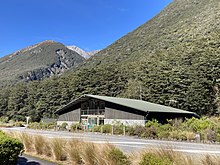
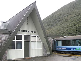
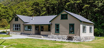
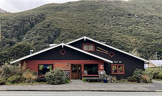
- Buildings
- Train station
- Arthur's Pass Chapel (built 1953)
- Arthur's Pass Store
- Outdoor Education Centre
- Wobbly Kea Cafe
- Aniwaniwa, historic chalet
- Typical cottage
References
- ^ a b "ArcGIS Web Application". statsnz.maps.arcgis.com. Retrieved 15 October 2021.
- ^ a b "Aotearoa Data Explorer". Statistics New Zealand. Retrieved 26 October 2024.
- ^ McLintock, A. H. (22 April 2009). "DOBSON BROTHERS". Te Ara – the Encyclopedia of New Zealand. Retrieved 30 September 2011.
- ^
McLintock, A. H. (22 April 2009). "Dobson Brothers". Te Ara – the Encyclopedia of New Zealand. Retrieved 21 November 2019.
At the same time George Dobson was sent to examine every available pass between the watershed of the Taramakau, Waimakariri, and the Hurunui, and after examining passes at the head of every valley he reported that 'Arthur's' pass was by far the most suitable for the direct crossing.
- ^ "The Arthur's Pass tumnel contraca [sic]". Colonist. Vol. L, no. 12140. 15 January 1908. p. 2. Retrieved 1 January 2010.
- ^ "The British and Intercolonial Exhibition, Hokitika, Westland, New Zealand, December 15th, 1923 to February 2nd, 1924 : to celebrate the opening of the East and West Coast railway, to commemorate the diamond jubilee of the Province of Westland, 1864–1924. – Version details – Trove". Retrieved 16 June 2020.
- ^ a b http://www.nzhistory.net.nz/timeline&new_date=12/3 Article on Arthur's Pass on NZ History website; accessed 1 January 2010
- ^ Reed, A. W. (2010). Peter Dowling (ed.). Place Names of New Zealand. Rosedale, North Shore: Raupo. p. 31. ISBN 978-0-14-320410-7.
- ^ "Major New Zealand earthquakes since 1855 - New Zealand Parliament". www.parliament.nz. Retrieved 5 June 2021.
- ^ 2018 Census place summary: Craigieburn
- ^ a b "Statistical area 1 dataset for 2018 Census". Statistics New Zealand. March 2020. 7026670.
- ^ "CliFlo -The National Climate Database (Agent number: 4638)". NIWA. Retrieved 30 July 2024.
- ^ "CliFlo -The National Climate Database (Agent numbers: 4513. 25821, 41489)". NIWA. Retrieved 31 July 2024.
- ^ "Arthur's Pass - Weather Database". Graeme Kates. Retrieved 5 June 2021.
- ^ Shaun Barnett &, Chris Maclean (2014). Tramping A New Zealand History. Nelson, New Zealand: Craig Potton Publishing. pp. 191–192.
- ^ "Arthur's Pass residents fight to save building at heart of national park". Stuff. 7 May 2021. Retrieved 9 May 2021.
- ^ Short walking tracks in Arthur's Pass, Department of Conservation.
- ^ Half-day walks in Arthur's Pass, Department of Conservation.
- ^ Day walks in Arthur's Pass, Department of Conservation.


