Angle Inlet, Minnesota
Angle Inlet | |
|---|---|
 Angle Inlet | |
 | |
Location in Minnesota | |
| Coordinates: 49°20′42″N 95°4′12″W / 49.34500°N 95.07000°W | |
| Country | United States |
| State | Minnesota |
| County | Lake of the Woods |
| Township | Angle |
| Area | |
• Total | 2.03 sq mi (5.25 km2) |
| • Land | 1.74 sq mi (4.50 km2) |
| • Water | 0.29 sq mi (0.75 km2) |
| Elevation | 1,063 ft (324 m) |
| Population (2020) | |
• Total | 54 |
| • Density | 31.07/sq mi (12.00/km2) |
| Time zone | UTC-6 (Central (CST)) |
| • Summer (DST) | UTC-5 (CDT) |
| ZIP Code | 56711 |
| Area code | 218 |
| GNIS feature ID | 639371[2] |
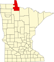
Angle Inlet is a census-designated place (CDP) and unincorporated community in Angle Township, Lake of the Woods County, Minnesota, United States. Its population was 54 as of the 2020 census. The community is part of the Northwest Angle, the only place in the contiguous United States north of the 49th parallel; it is the northernmost census-designated place in the contiguous United States.[3] The French built Fort Saint Charles nearby in 1732.
Angle Inlet has the last one-room school in Minnesota[4] and a post office with a sign stating that it is the "Most Northerly P.O. in Contiguous U.S."[5] To travel to Angle Inlet by road from other parts of Minnesota, or from anywhere in the United States, requires driving through Manitoba, Canada.
Demographics
| Census | Pop. | Note | %± |
|---|---|---|---|
| 2010 | 60 | — | |
| 2020 | 54 | −10.0% | |
| U.S. Decennial Census[6] | |||
In the 2020 US Census Angle Inlet's population was approximately 54,[7] down by 10% from 60 in the 2010 Census.[8]
Climate
Angle Inlet has a warm-summer humid continental climate (Dfb), with a plant hardiness zone of 3b with an average annual extreme minimum temperature of −32.6 °F (−35.9 °C).[9] Due to its high latitude and being in the middle of a continent, it is a contender for the most extreme winters in the contiguous United States.
There is no weather station in the area, but the PRISM Climate Group, a project of Oregon State University, provides interpolated data for the area based on the climates of nearby areas.
| Climate data for Angle Inlet, MN. Elev: 1,079 ft (329 m) | |||||||||||||
|---|---|---|---|---|---|---|---|---|---|---|---|---|---|
| Month | Jan | Feb | Mar | Apr | May | Jun | Jul | Aug | Sep | Oct | Nov | Dec | Year |
| Mean maximum °F (°C) | 36.4 (2.4) |
37.6 (3.1) |
51.4 (10.8) |
67.1 (19.5) |
79.3 (26.3) |
84.7 (29.3) |
86.2 (30.1) |
85.4 (29.7) |
80.7 (27.1) |
69.4 (20.8) |
51.2 (10.7) |
37.1 (2.8) |
89.1 (31.7) |
| Mean daily maximum °F (°C) | 12.9 (−10.6) |
18.0 (−7.8) |
31.8 (−0.1) |
46.5 (8.1) |
60.8 (16.0) |
70.6 (21.4) |
76.1 (24.5) |
74.3 (23.5) |
64.4 (18.0) |
49.0 (9.4) |
32.4 (0.2) |
18.4 (−7.6) |
46.3 (7.9) |
| Daily mean °F (°C) | 3.3 (−15.9) |
7.2 (−13.8) |
21.2 (−6.0) |
36.9 (2.7) |
51.5 (10.8) |
62.2 (16.8) |
66.6 (19.2) |
64.9 (18.3) |
55.2 (12.9) |
41.5 (5.3) |
25.6 (−3.6) |
10.5 (−11.9) |
37.2 (2.9) |
| Mean daily minimum °F (°C) | −6.3 (−21.3) |
−3.6 (−19.8) |
10.6 (−11.9) |
27.4 (−2.6) |
42.2 (5.7) |
53.8 (12.1) |
57.1 (13.9) |
55.6 (13.1) |
46.0 (7.8) |
33.9 (1.1) |
18.8 (−7.3) |
2.5 (−16.4) |
28.2 (−2.1) |
| Mean minimum °F (°C) | −30.6 (−34.8) |
−26.4 (−32.4) |
−15.4 (−26.3) |
12.0 (−11.1) |
28.7 (−1.8) |
41.6 (5.3) |
46.6 (8.1) |
44.7 (7.1) |
32.7 (0.4) |
20.6 (−6.3) |
−0.2 (−17.9) |
−22.0 (−30.0) |
−32.6 (−35.9) |
| Average precipitation inches (mm) | 0.73 (19) |
0.62 (16) |
0.86 (22) |
1.33 (34) |
3.00 (76) |
4.17 (106) |
3.55 (90) |
3.01 (76) |
3.03 (77) |
2.27 (58) |
1.04 (26) |
0.95 (24) |
24.57 (624) |
| Average relative humidity (%) | 82.9 | 81.7 | 74.6 | 63.3 | 63.9 | 71.3 | 74.7 | 74.3 | 76.4 | 76.3 | 83.1 | 85.0 | 74.9 |
| Average dew point °F (°C) | −0.7 (−18.2) |
2.8 (−16.2) |
14.4 (−9.8) |
25.6 (−3.6) |
39.7 (4.3) |
52.8 (11.6) |
58.3 (14.6) |
56.5 (13.6) |
47.9 (8.8) |
34.6 (1.4) |
21.2 (−6.0) |
6.9 (−13.9) |
30.0 (−1.1) |
| Source: PRISM Climate Group[10] | |||||||||||||
References
- ^ "2020 U.S. Gazetteer Files". United States Census Bureau. Retrieved July 24, 2022.
- ^ "Angle Inlet". Geographic Names Information System. United States Geological Survey, United States Department of the Interior.
- ^ Lake of the Woods Co. General Highway Map (PDF) (Map). 2011. p. 3. Archived from the original (PDF) on September 4, 2012. Retrieved March 9, 2012.
- ^ Ross, Jenna (June 1, 2015). "Minnesota's last one-room schoolhouse counts on its longtime teacher". Star Tribune. Minneapolis, Minnesota.
- ^ "Chapter 4: The Watery Boundary". United Divide: A Linear Portrait of the USA/Canada Border. The Center for Land Use Interpretation. Winter 2015.
- ^ "Census of Population and Housing". Census.gov. Retrieved June 4, 2016.
- ^ "Justice Map - Visualize race and income data for your community". www.justicemap.org. Retrieved November 14, 2022.
- ^ "Angle Inlet, Minnesota". Retrieved August 13, 2023.
- ^ "USDA Interactive Plant Hardiness Map". United States Department of Agriculture. Archived from the original on June 18, 2021. Retrieved July 12, 2019.
- ^ "PRISM Climate Group, Oregon State University". www.prism.oregonstate.edu. Archived from the original on July 25, 2019. Retrieved July 12, 2019.


