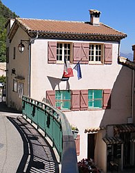
Amirat
Amirat | |
|---|---|
 The town hall of Amirat | |
| Coordinates: 43°53′29″N 6°49′30″E / 43.8914°N 6.825°E | |
| Country | France |
| Region | Provence-Alpes-Côte d'Azur |
| Department | Alpes-Maritimes |
| Arrondissement | Grasse |
| Canton | Grasse-1 |
| Intercommunality | Pays de Grasse |
| Government | |
| • Mayor (2020–2026) | Jean-Louis Conil[1] |
Area 1 | 12.95 km2 (5.00 sq mi) |
| Population (2021)[2] | 51 |
| • Density | 3.9/km2 (10/sq mi) |
| Time zone | UTC+01:00 (CET) |
| • Summer (DST) | UTC+02:00 (CEST) |
| INSEE/Postal code | 06002 /06910 |
| Elevation | 725–1,373 m (2,379–4,505 ft) (avg. 860 m or 2,820 ft) |
| 1 French Land Register data, which excludes lakes, ponds, glaciers > 1 km2 (0.386 sq mi or 247 acres) and river estuaries. | |
Amirat (French pronunciation: [amiʁa]; Italian: Ammirato) is a commune in the Alpes-Maritimes department in southeastern France.
Geography
This little village is made up of three quarters:
- The Agots, with the church and the hostel.
- Amirat village, where the mayor's office is located.
- Maupoil, location of the 16th century Saint Jeannet's Chapel.
Politics
Amirat had the fourth highest percentage of people who voted for Jean-Marie Le Pen of all French communes during the second round of voting in 2002 - 59.26%.[3]
Population
The commune's inhabitants are known as Amiratois.
| Year | Pop. | ±% p.a. |
|---|---|---|
| 1968 | 39 | — |
| 1975 | 40 | +0.36% |
| 1982 | 72 | +8.76% |
| 1990 | 50 | −4.46% |
| 1999 | 41 | −2.18% |
| 2007 | 35 | −1.96% |
| 2012 | 63 | +12.47% |
| 2017 | 67 | +1.24% |
| Source: INSEE[4] | ||
Sights
Saint Jeannet's Chapel, a 16th-century chapel with lovely wooden gate in Maupoil.
See also
References
- ^ "Répertoire national des élus: les maires" (in French). data.gouv.fr, Plateforme ouverte des données publiques françaises. 13 September 2022.
- ^ "Populations légales 2021" (in French). The National Institute of Statistics and Economic Studies. 28 December 2023.
- ^ Résultats de l'élection présidentielle de 2002 : Amirat, politiquemania.com
- ^ Population en historique depuis 1968, INSEE
External links


