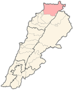
Akkar District
Akkar قضاء عكار | |
|---|---|
 Coastline | |
 Location in Lebanon | |
| Coordinates (Halba): 34°33′02″N 036°04′41″E / 34.55056°N 36.07806°E | |
| Country | |
| Governorate | Akkar |
| Area | |
• Total | 788 km2 (304 sq mi) |
| Population | |
• Estimate (31 December 2017)[2] | 423,596 |
| Time zone | UTC+2 (EET) |
| • Summer (DST) | UTC+3 (EEST) |
Akkar District (Arabic: قضاء عكار) is the only district in Akkar Governorate, Lebanon. It is coextensive with the governorate and covers an area of 788 km2 (304 sq mi). The UNHCR estimated the population of the district to be 389,899 in 2015, including 106,935 registered refugees of the Syrian Civil War and 19,404 Palestinian refugees.[1] The capital is at Halba.
The district is characterized by the presence of a relatively large coastal plain, with high mountains to the east. The largest cities in Akkar are Halba, Bire Akkar and Al-Qoubaiyat.
Akkar has many important Roman and Arabic archaeological sites. One of the most famous archaeological sites and the birthplace of the Roman emperor Severus Alexander (d.235) is the Tell of Arqa near the town of Miniara. Several prehistoric sites were found in the Akkar plain foothills that were suggested to have been used by the Heavy Neolithic Qaraoun culture at the dawn of the Neolithic Revolution.[3][4]
Akkar can be divided into 7 parts: Qaitea (القيطع), Jouma (الجومة), Dreib (الدريب), Jabal Akroum (جبل أكروم), Wadi Khaled (وادي خالد), Cheft (الشفت) and As-Sahel (السهل).[5]
History
The Akkar area is strategically important as it is the northern gateway into Syria. this is why several castles were built in that area and in Syria. The most notable one is probebly Krak des Chevaliers in Syria. During the 19th century the Mir‘abi families of beys and pashas bought many lands in the area, which France found it helpful with their Mandate over Lebanon. Up to the 1958 Syrian land reforms, the local population of Akkar could move freely in and out of Syria.[6]
Peasants revolt
During the 1970s the peasants of Akkar formed an alliance to fight the land owners and the system of which 3% of the population held about 73% of the land. They were led by Khalid Saghiya, a Syrian Baathist lawyer from Baynu. Following Black September in Jordan, firearms were accessible to all. A fact that escalated the revolt. The involvement of Syria in the area as well as the diverse population led to many rivalries. Franjieh and the Phalange were rivals. Peasant laborers clashed with landlords, while Jurd clans, though occasionally in conflict with one another, had formed an alliance against the beys. Eventually the discovey of oil in the gulf led to mass imigration, sparing the region and its population from the fate that came to many other parts of Lebanon.[6]
Geography
Akkar is divided into the following regions:
- Al-Jouma: represents multiple villages connected to each other by a network of roads, and is located around fertile land that enable it to adopt greenhouse and fruit crops.
- Najd Akkar: It is divided into three sub-regions according to the geographical situation that makes the crops change according to the height and irrigation: Al-Shafat, Al-Dreib Al-Awsat, Al-Dreib Al-A'la
- The plateaus where the al-Qayt'a region is.
- Jarad Akkar: It occupies an area in the east of the entire region, starting from the borders of the Akkar governorate to Abu Musa River in the south to the Syrian border in the north, and it consists of the following villages.
- The plain: in itself it is the source of agricultural wealth, where its inhabitants live from the land, and 6% of the properties include half of the lands.
Demographics
As of 2022, the religious make-up of the District's 309,517 voters were roughly 69% Sunni, 13% Greek Orthodox, 10% Maronite Catholics, 5% Alawite, 1% Shia, and 2% others.[7]
This region is home to the second-largest population of Alawites in Lebanon. Turkish people form a majority in Kouachra and Aydamun.
References
- ^ a b "Akkar Governorate Profile". UNHCR. June 2015. Retrieved 19 February 2017.
- ^ Brinkhoff, Thomas (2 March 2019). "Lebanon: Administrative Division". City Population. Retrieved 3 July 2021.
- ^ L. Copeland; P. Wescombe (1966). Inventory of Stone-Age Sites in Lebanon: North, South and East-Central Lebanon, pp. 20-21. Impr. Catholique. Retrieved 3 March 2011.
- ^ Wetzel, R. & Haller, J., Le Quarternaire de la région de Tripoli. Notes et Mémoires de la Délégation Générale de France au Liban. Section Géologique, No. 4. Beirut, 1945.
- ^ "Akkar" (PDF).
- ^ a b Ufheil-Somers, Amanda (1990-01-10). "'Akkar Before the Civil War". MERIP. Retrieved 2024-09-29.
- ^ "Mapping Lebanon: Data and statistics".

