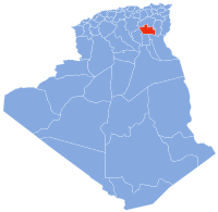
Ain Zaatout
Aïn Zaatout | |
|---|---|
Commune and town | |
 | |
| Country | |
| Province | Biskra Province |
| District | El Kantara District |
| Population (1998) | |
• Total | 2,230 |
| Time zone | UTC+1 (CET) |


Ain Zaatout (Arabic: عين زعطوط) is the administrative name of a mountainous village in north east Algeria, called Ah Frah in the local Shawi dialect, and Beni Farah (sometimes spelled Beni Ferah) (Arabic: بني فرح) in Arabic.[1]
It is located at 35.14° North, 5.83° East, at the southern edge of the Saharan Atlas between the provinces of Batna and Biskra. The region is largely rocky with an average altitude of more than 900 metres (2,953 feet) above sea level.
Aïn Zaatout has an estimated population of around 5,000 composed of Farhi people, Muslim Berbers speaking a distinctive variant of the Shawi dialect used in the Aurès.
References
- ^ "Algeria: Administrative Division (Provinces and Communes) - Population Statistics, Charts and Map". www.citypopulation.de. Retrieved 2022-03-03.

