Acre Sanjak
| Sanjak of Acre Akka Sancağı سنجق عكا | |||||||
|---|---|---|---|---|---|---|---|
| sanjak of the Ottoman Empire Under Damascus Eyalet (1519–1660) Under Sidon Eyalet (1660–1864) Under Syria Vilayet (1864–1888) Under Beirut Vilayet (1888–1918) | |||||||
| c. 18th century–1918 | |||||||
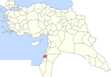
 Sanjak of Acre in 1914 | |||||||
| Capital | Acre | ||||||
| History | |||||||
• Established | c. 18th century | ||||||
| 1918 | |||||||
| |||||||
The Sanjak of Acre (Arabic: سنجق عكا; Turkish: Akka Sancağı), often referred as Late Ottoman Galilee, was a prefecture (sanjak) of the Ottoman Empire, located in modern-day northern Israel. The city of Acre was the Sanjak's capital.
Acre was captured by the Ottoman Sultan Selim I in 1517, but the city fell into disuse soon thereafter and was governed under the Sanjak of Safad during 16th-18th centuries. Acre was the center of the Nahiya of Acre, a subdistrict of the sanjak, which also included the villages of Buqei'a, Al-Tira, Julis, Kafr Yasif, Kabul and Shefa-'Amr.[1] Acre was the center of a major economic boom under the leadership of Zahir al-Umar during the late 18th century.
The Sanjak of Acre was created c. early 18th century as a prefecture of the Sidon Eyalet. The Sidon Eyalet later became known as the Acre Eyalet between 1775 and 1841 when Acre was designated as the eyalet's capital city. Following the promulgation of the Vilayet Law as per the then-ongoing Tanzimat, or administrative reforms, in 1864, the sanjak of Acre was annexed to the newly created Syria Vilayet. In 1888, the sanjaks of Acre, Latakia, Tripoli, Beirut, and Nablus were separated from the Syria Vilayet and transferred to the Beirut Vilayet.[2]
Subdistricts
The sanjak was made up of five districts (kazas):
- Kaza of Acre (Akka)
- Kaza of Haifa (Hayfa)
- Kaza of Safed
- Kaza of Nazareth (Nasıra)
- Kaza of Tiberias (Taberiye)
References
- ^ David, Abraham (2010). To Come to the Land: Immigration and Settlement in 16th-Century Eretz-Israel. Dena Ordan (translator). University of Alabama Press. pp. 27-28. ISBN 978-0-8173-5643-9. Retrieved 24 October 2011.
- ^ Eurosis European Multidisciplinary Society for Modelling and Simulation Technology
