Abiras
4°08′06″N 22°26′24″E / 4.135°N 22.440°E

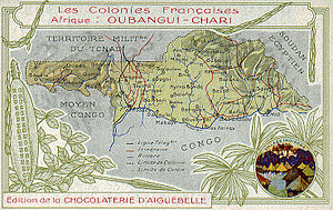
Abiras (French: les Abiras) is a former settlement that was located on the northern bank of the Ubangi River at its source, the confluence of the Mbomou and Welle rivers. It was located opposite from the Congolese city of Yakoma in the area of the present-day Central African Republic.
It was not until 1882 or ’83 that the German explorer Wilhelm Junker established that the Welle flowed into the Mbomou; the Belgian agent Alphonse Vangele established the Yakoma post in 1890. The Frenchman Gaston Gaillard then received a grant from the Yakoma leader Inkesse on the north bank[1] and established Abiras on September 7, 1891.[2] During the initial French settlement of central Africa, Abiras served as the capital of the French Congo's territory of Upper Ubangi (Haut-Oubangui) and then as the first capital of the colony of Ubangi-Shari (Oubangui-Chari).[3] It was replaced in 1906 first by Fort de Possel and then by Bangi, the present-day Bangui.[4]
Coordinates are based on aerial photographs; a statement that in 1894, "a large French expedition had massed at Abiras (junction of the Wellé and Mbomu Rivers)";[5] and a statement "Elsewhere we learn that Abiras, at the mouth of the Mbomu...".[6] There are a number of villages in the area in the present day, such as André.
References
- ^ Kalck, Pierre and trans. by Xavier-Samuel Kalck. Historical Dictionary of the Central African Republic, 3rd ed., p. 81: "Gaillard, Gaston". Scarecrow Press (Lanham), 2005. Accessed 30 Mar 2014.
- ^ The World at War: "Ubangi-Shari 1870–1960". Accessed 30 Mar 2014.
- ^ "Chad and Ubangi-Shari to 1922".
- ^ World Statesmen. "Central African Republic". Accessed 29 Mar 2014.
- ^ Blackwood's Edinburgh Magazine. Vol. 156. W. Blackwood. July 1897. p. 146.
- ^ Samarin, William J. (1989). "The Colonial Heritage of the Central African Republic". The International Journal of African Historical Studies. 22 (4). Boston University African Studies Center: 697–711. doi:10.2307/219060. hdl:1807/67618. JSTOR 219060.
