Valloire
Valloire | |
|---|---|
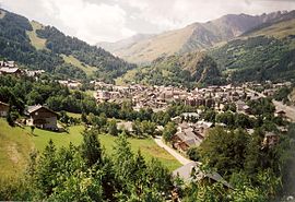
 A general view of Valloire | |
| Coordinates: 45°09′57″N 6°25′45″E / 45.1658°N 6.4292°E | |
| Country | France |
| Region | Auvergne-Rhône-Alpes |
| Department | Savoie |
| Arrondissement | Saint-Jean-de-Maurienne |
| Canton | Modane |
| Intercommunality | Maurienne-Galibier |
| Government | |
| • Mayor (2020–2026) | Jean-Pierre Rougeaux[1] |
Area 1 | 137.48 km2 (53.08 sq mi) |
| Population (2022)[2] | 1,074 |
| • Density | 7.8/km2 (20/sq mi) |
| Time zone | UTC+01:00 (CET) |
| • Summer (DST) | UTC+02:00 (CEST) |
| INSEE/Postal code | 73306 /73450 |
| Elevation | 694–3,504 m (2,277–11,496 ft) |
| Website | Valloire.net |
| 1 French Land Register data, which excludes lakes, ponds, glaciers > 1 km2 (0.386 sq mi or 247 acres) and river estuaries. | |
| Valloire-Galibier | |
|---|---|
 | |
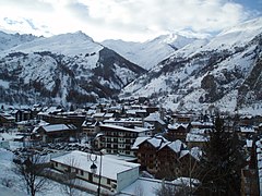
 Image of valloire village and two of its mountains, la Setaz and le Crey Du Quart. | |
| Location | Valloire, France |
| Nearest major city | St Jean de Maurienne, France |
| Top elevation | 3000m+ |
| Trails | 80 |
| Website | http://www.valloire.net/fr/hiver/ |
Valloire ([valwaʁ]; Arpitan: Valouère, Vârouère) is a commune in the Savoie department in the Auvergne-Rhône-Alpes region in south-eastern France.
The ski resort Valloire-Galibier is located in the commune, at the foot of the Col du Télégraphe and next to the ski resort of Valmeinier, (the alps) France.
70% of the Valloire/Valmeinier ski area is above 2,000 m (6,600 ft). It offers over 150 km of slopes, 33 lifts 2 gondolas, 17 chairlift & 14 drag lifts), and 85 slopes, (21 Green, 25 Blue, 31 Red and 6 Black[3]). There is also a considerable amount of backcountry skiing available.
Valloire has two main skiing areas which can be accessed by lifts from the village. They are the Sétaz and the Crey du Quart. From the Crey du Quart you can ski across to Valmeinier,[4] which is included in the ski pass. The Crey du Quart also houses a large snowpark (with a dedicated daily ticket only for this park) which is designed to offer something to people of all skill levels. In the Arva Parc on the Sétaz one can learn how to rescue avalanche victims. The French Foreign Legion has a mountain outpost at Valloire Les Verneys and teaches beginning legionnaires on the slopes. Jaime Salazar dedicated a chapter in his 2005 Foreign Legion memoir Legion of the Lost to the severe mountain course in Valloire.
It is a traditional village known for its après-ski and restaurants. The resort includes two ski schools École du Ski Français, which is the largest ski school company in France and "Ecole du Ski Internationale".
It is ideally located in the Savoie region with good transport links in and out of Modane, Lyon, Geneva and Chambery.
Valloire is known as an art resort. Since 1984, it has been organizing the International Competition of Ice Sculptures and Snow Sculptures around January 18 each year. The resort located at the foot of the mythical Col du Galibier is also an essential part of the Tour de France: stage town on 3 occasions (1972, 1975 and 2019) and arrival in 2011 at the top of the Col du Galibier;
History
During the early 1930s, Valloire was a simple village, void of tourism. In 1935–36, the first ski club arrived; "Le Ski club de Paris". New hotels and an ice skating rink were opened. In the next two years, Valloire constructed its first ski lift. By 1945, it had added another 5 lifts. In 1970 Valloire expanded from the Sétaz and began developing the Crey du Quart. Four years later, Valloire and Valmeinier joined together to form one ski resort.
In 1989 the first snow cannons were unveiled, allowing for a more lengthy tourism season. Similar progress was made until 2007, when Valloire switched from conventional ski passes to "hands-free" ones, imbedded with a chip. Valloire has recently gained fame as the home of Jean-Baptiste Grange, a slalom World Cup winner.
In 2024 the Tour de France had a finish in Valloire in the fourth stage.
Geography
Climate
Valloire has a humid continental climate (Köppen climate classification Dfb) closely bordering on an oceanic climate (Cfb). The average annual temperature in Valloire is 7.0 °C (44.6 °F). The average annual rainfall is 793.6 mm (31.24 in) with November as the wettest month. The temperatures are highest on average in July, at around 15.4 °C (59.7 °F), and lowest in January, at around −0.7 °C (30.7 °F). The highest temperature ever recorded in Valloire was 33.1 °C (91.6 °F) on 28 July 2013; the coldest temperature ever recorded was −23.0 °C (−9.4 °F) on 5 February 2012.
| Climate data for Valloire (1991−2020 normals, extremes 1991−present) | |||||||||||||
|---|---|---|---|---|---|---|---|---|---|---|---|---|---|
| Month | Jan | Feb | Mar | Apr | May | Jun | Jul | Aug | Sep | Oct | Nov | Dec | Year |
| Record high °C (°F) | 16.8 (62.2) |
17.6 (63.7) |
19.5 (67.1) |
23.8 (74.8) |
29.4 (84.9) |
32.5 (90.5) |
33.1 (91.6) |
32.6 (90.7) |
27.3 (81.1) |
27.5 (81.5) |
20.2 (68.4) |
16.8 (62.2) |
33.1 (91.6) |
| Mean daily maximum °C (°F) | 3.7 (38.7) |
4.2 (39.6) |
8.0 (46.4) |
11.5 (52.7) |
15.5 (59.9) |
19.3 (66.7) |
21.6 (70.9) |
21.2 (70.2) |
16.8 (62.2) |
12.8 (55.0) |
7.2 (45.0) |
4.2 (39.6) |
12.2 (54.0) |
| Daily mean °C (°F) | −0.7 (30.7) |
−0.5 (31.1) |
2.8 (37.0) |
6.2 (43.2) |
9.9 (49.8) |
13.4 (56.1) |
15.4 (59.7) |
15.3 (59.5) |
11.4 (52.5) |
7.9 (46.2) |
2.9 (37.2) |
0.0 (32.0) |
7.0 (44.6) |
| Mean daily minimum °C (°F) | −5.2 (22.6) |
−5.3 (22.5) |
−2.4 (27.7) |
0.9 (33.6) |
4.4 (39.9) |
7.5 (45.5) |
9.2 (48.6) |
9.3 (48.7) |
6.0 (42.8) |
3.0 (37.4) |
−1.3 (29.7) |
−4.2 (24.4) |
1.8 (35.2) |
| Record low °C (°F) | −19.6 (−3.3) |
−23.0 (−9.4) |
−18.6 (−1.5) |
−9.6 (14.7) |
−4.9 (23.2) |
−3.1 (26.4) |
0.2 (32.4) |
−0.3 (31.5) |
−5.1 (22.8) |
−9.8 (14.4) |
−14.9 (5.2) |
−18.2 (−0.8) |
−23.0 (−9.4) |
| Average precipitation mm (inches) | 70.2 (2.76) |
52.5 (2.07) |
55.5 (2.19) |
51.6 (2.03) |
71.8 (2.83) |
65.1 (2.56) |
62.5 (2.46) |
67.0 (2.64) |
63.8 (2.51) |
72.5 (2.85) |
82.0 (3.23) |
79.1 (3.11) |
793.6 (31.24) |
| Average precipitation days (≥ 1.0 mm) | 8.8 | 7.6 | 7.9 | 8.8 | 11.2 | 10.3 | 8.6 | 8.9 | 8.2 | 8.4 | 9.5 | 8.9 | 107.1 |
| Source: Météo-France[5] | |||||||||||||
See also
References
- ^ "Répertoire national des élus: les maires" (in French). data.gouv.fr, Plateforme ouverte des données publiques françaises. 4 May 2022.
- ^ "Populations de référence 2022" (in French). The National Institute of Statistics and Economic Studies. 19 December 2024.
- ^ "Valloire Skiing Holidays | Ski Apartments | Peak Retreats".
- ^ "Valloire - Village - France - Maurienne Valley".
- ^ "Fiche Climatologique Statistiques 1991-2020 et records" (PDF) (in French). Météo-France. Retrieved September 10, 2022.


