Tuitjenhorn
Tuitjenhorn | |
|---|---|
Village | |
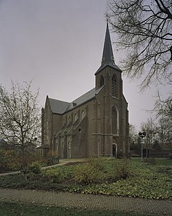
 Church of Saint James | |
| Coordinates: 52°44′N 4°45′E / 52.733°N 4.750°E | |
| Country | Netherlands |
| Province | North Holland |
| Municipality | Schagen |
| Area | |
• Total | 3.20 km2 (1.24 sq mi) |
| Elevation | −0.8 m (−2.6 ft) |
| Population (2021)[1] | |
• Total | 3,460 |
| • Density | 1,100/km2 (2,800/sq mi) |
| Time zone | UTC+1 (CET) |
| • Summer (DST) | UTC+2 (CEST) |
| Postal code | 1747[1] |
| Dialing code | 0226 |
Tuitjenhorn (West Frisian: Tutinghorn) is a village in the Dutch province of North Holland. It is a part of the municipality of Schagen. Tuitjenhorn was the main village of the former Harenkarspel municipality. Tuitjenhorn lies about 9 km northwest of Heerhugowaard.
The village was first mentioned between 1280 and 1287 as "van tutinghehorne". The etymology is unclear.[3] Tuitjenhorn is a dike village. The Catholic St Jacobus de Meerdere Church is a basilica-like church built between 1857 and 1859 and has been built around a tower from 1810.[4]
Famous Tuitjenhorners
- Gerard Kuiper, Dutch-American astronomer
- Daniella van Graas, Dutch fashion model and actress
- Celeste Plak, Dutch volleyball player
- Femke Meines, Dutch singer
Gallery
- Farm in Tuitjenhorn
- Windmill of Piet (folly which serves as landmark in the local "Van Blanckendaell Park" zoo)
References
- ^ a b c "Kerncijfers wijken en buurten 2021". Central Bureau of Statistics. Retrieved 1 May 2022.
minus Kalverdijk
- ^ "Postcodetool for 1747CA". Actueel Hoogtebestand Nederland (in Dutch). Het Waterschapshuis. Retrieved 1 May 2022.
- ^ "Tuitjenhorn - (geografische naam)". Etymologiebank (in Dutch). Retrieved 1 May 2022.
- ^ Ronald Stenvert & Saskia van Ginkel-Meester (2006). "Tuitjenhorn" (in Dutch). Zwolle: Waanders. Retrieved 1 May 2022.


