Tessalit
Tessalit | |
|---|---|
Commune and village | |
| Coordinates: 20°12′04″N 1°0′45″E / 20.20111°N 1.01250°E | |
| Country | |
| Region | Kidal Region |
| Cercle | Tessalit Cercle |
| Area | |
• Total | 30,000 km2 (10,000 sq mi) |
| Population (2009)[2] | |
• Total | 5,739 |
| Time zone | UTC+0 (GMT) |


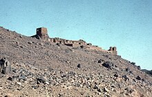
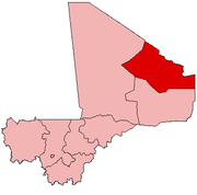
Tessalit is a rural commune and village in the Kidal Region of Mali. The village is the administrative centre of Tessalit Cercle (district). The village lies 85 kilometres (53 mi) north of Adjelhoc and about 70 kilometres (43 mi) from the Algerian border. The commune extends over an area of 30,000 square kilometres (12,000 sq mi) that is almost entirely desert. In the 2009 census the commune had a population of 5,739.[2]
It is served by Tessalit Airport.
Tessalit is an oasis in the Sahara desert and a stop for trans-Saharan travellers. A gypsum deposit and a plaster factory also contribute to the local economy, though these activities have been disrupted in recent decades by the Tuareg Rebellions and terrorism in neighboring Algeria.
The Malian government have a military base at the village of Tessalit.[3][4]
Tessalit is situated in the mountain range of Adrar des Ifoghas. It is primarily populated by Tuaregs and is the home of the musical group Tinariwen as well as the poet Souéloum Diagho. The village is twinned with Saint-Jean-de-Maurienne, France.[citation needed]
The cercle of Tessalit contains the communes of Tessalit, Adjelhoc, and Timtaghene.
Battle of Tessalit
Tuareg rebels defeated Malian government forces to take the village in 2012. Attempts by the Malian Air Force, using Ukrainian mercenaries, were unable to prevent the defeat.
French paratroopers took the local airport and then were joined by French and African Forces landing at the airport. They recaptured Tessalit on Feb. 8, 2013, according to General Staff spokesman Colonel Thierry Burkhard.[5]
2020
French forces killed the head of Al-Qaeda in the Islamic Maghreb (AQIM), Abdelmalek Droukdel on June 5, 2020, near Tessalit. While France is concentrating its anti-terrorist efforts on the Islamic State in the Greater Sahara (IS-GS), a spokesperson indicated that does not preclude other activities. Droukdel was buried at the scene.[6]
Climate
| Climate data for Tessalit, Mali (1961-1990 normals, extremes 1948-1994) | |||||||||||||
|---|---|---|---|---|---|---|---|---|---|---|---|---|---|
| Month | Jan | Feb | Mar | Apr | May | Jun | Jul | Aug | Sep | Oct | Nov | Dec | Year |
| Record high °C (°F) | 36.0 (96.8) |
39.0 (102.2) |
42.5 (108.5) |
44.0 (111.2) |
46.4 (115.5) |
46.3 (115.3) |
49.0 (120.2) |
45.0 (113.0) |
44.5 (112.1) |
43.4 (110.1) |
39.0 (102.2) |
35.6 (96.1) |
49.0 (120.2) |
| Mean daily maximum °C (°F) | 26.8 (80.2) |
29.9 (85.8) |
33.3 (91.9) |
37.0 (98.6) |
40.7 (105.3) |
42.7 (108.9) |
41.6 (106.9) |
40.6 (105.1) |
40.3 (104.5) |
37.3 (99.1) |
31.9 (89.4) |
27.1 (80.8) |
35.8 (96.4) |
| Daily mean °C (°F) | 19.7 (67.5) |
22.5 (72.5) |
25.7 (78.3) |
29.4 (84.9) |
33.3 (91.9) |
35.8 (96.4) |
34.9 (94.8) |
33.9 (93.0) |
33.5 (92.3) |
30.5 (86.9) |
25.1 (77.2) |
20.3 (68.5) |
28.7 (83.7) |
| Mean daily minimum °C (°F) | 12.6 (54.7) |
15.0 (59.0) |
18.0 (64.4) |
21.8 (71.2) |
25.8 (78.4) |
28.9 (84.0) |
28.1 (82.6) |
27.1 (80.8) |
26.7 (80.1) |
23.6 (74.5) |
18.2 (64.8) |
13.5 (56.3) |
21.6 (70.9) |
| Record low °C (°F) | 3.3 (37.9) |
4.4 (39.9) |
7.0 (44.6) |
8.7 (47.7) |
12.1 (53.8) |
18.4 (65.1) |
16.0 (60.8) |
14.0 (57.2) |
12.9 (55.2) |
9.0 (48.2) |
6.3 (43.3) |
3.3 (37.9) |
3.3 (37.9) |
| Average precipitation mm (inches) | 0.4 (0.02) |
0.1 (0.00) |
0.7 (0.03) |
0.5 (0.02) |
4.6 (0.18) |
6.1 (0.24) |
16.6 (0.65) |
26.1 (1.03) |
11.6 (0.46) |
1.1 (0.04) |
0.3 (0.01) |
0.4 (0.02) |
68.5 (2.7) |
| Average rainy days | 0.2 | 0.1 | 0.2 | 0.2 | 0.7 | 1.2 | 3.3 | 5.1 | 2.5 | 0.4 | 0.2 | 0.2 | 14.3 |
| Average relative humidity (%) | 23 | 19 | 17 | 14 | 15 | 18 | 26 | 33 | 24 | 19 | 22 | 21 | 21 |
| Mean monthly sunshine hours | 253.4 | 248.6 | 259.3 | 255.1 | 271.3 | 166.2 | 139.5 | 154.0 | 148.6 | 264.7 | 262.3 | 238.8 | 2,661.8 |
| Percent possible sunshine | 75 | 78 | 70 | 68 | 68 | 42 | 34 | 39 | 41 | 74 | 79 | 71 | 61 |
| Source 1: NOAA[7] | |||||||||||||
| Source 2: DWD (extremes, humidity 1973-1994)[8] | |||||||||||||
Notable People
- Mohamed Ag Erlaf (born 1956) - politician
References
- ^ Programme d'Appui au Développement des Régions du Nord: Guide de Collecte des Données Cercle de Tessalit (in French), Ministère de l'Administration Territoriale et des Collectivités Locales. République du Mali., 2007, archived from the original on 2012-07-20.
- ^ a b Resultats Provisoires RGPH 2009 (Région de Kidal) (PDF) (in French), République de Mali: Institut National de la Statistique.
- ^ "Tessalit". OpenStreetMap. Retrieved 17 June 2018.
- ^ "Tessalit". HERE Maps. HERE. Retrieved 17 June 2018.
- ^ French forces control strategic Mali town Tessalit, Expatica French News, Feb 8, 2013
- ^ "'Capture not possible': France's desert operation against Al-Qaeda chief". news.yahoo.com. Retrieved June 13, 2020.
- ^ "Tessalit Climate Normals 1961-1990". National Oceanic and Atmospheric Administration. Retrieved January 17, 2023.
- ^ "Klimatafel von Tessalit / Mali" (PDF). Deutscher Wetterdienst. Retrieved January 17, 2023.


