Sunnyside, Arizona
Sunnyside, Arizona | |
|---|---|
| Coordinates: 31°26′02″N 110°24′18″W / 31.43389°N 110.40500°W | |
| Country | United States |
| State | Arizona |
| County | Cochise |
| Elevation | 5,814 ft (1,772 m) |
| Time zone | UTC-7 (Mountain (MST)) |
| • Summer (DST) | UTC-7 (MST) |
| Area code | 520 |
| FIPS code | 04-70575 |
| GNIS feature ID | 34962 |
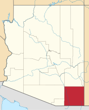
Sunnyside is a populated place situated in the far west of Cochise County, Arizona, United States, located just north of the international border with Mexico.[2] It has an estimated elevation of 5,814 feet (1,772 m) above sea level.[1]
History
Sunnyside was founded as a religious commune by Samuel Donnelly. Donnelly also co-founded the Copper Glance Mine. Donnelly's followers were known as Donnellites, a term Donnelly himself disliked. In 1900, Donnelly became sick with Bright's disease and died on April 14, 1901. By 1903, nearly everyone had left Sunnyside. Around 1912, the camp was revived as a ranching community.[3]
Sunnyside's population in 1940 was 2 residents.[4]
Although designated officially as a 'populated place', there are no inhabitants, and Sunnyside is known locally as a ghost town.[5]
References
- ^ a b "Feature Detail Report for: Sunnyside". Geographic Names Information System. United States Geological Survey, United States Department of the Interior.
- ^ "Sunnyside (in Cochise County, AZ) Populated Place Profile". AZ Hometown Locator. Retrieved May 4, 2017.
- ^ Weiser, Kathy (2007). "Sunnyside, Arizona – A Different Kind of Ghost Town – Legends of America". www.legendsofamerica.com. Retrieved November 20, 2022.
- ^ The Attorneys List. United States Fidelity and Guaranty Company, Attorney List Department. 1940. p. 89.
- ^ Varney, Philip (1980). "Nine: South of Sonoita". Arizona's Best Ghost Towns. Flagstaff: Northland Press. pp. 95–96, 101. ISBN 0873582179.
External links
 Media related to Sunnyside, Arizona at Wikimedia Commons
 Ghost towns travel guide from Wikivoyage
- Sunnyside – ghosttowns.com
- Sunnyside – Ghost Town of the Month at azghosttowns.com


