Solnice
Solnice | |
|---|---|
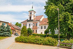
 Town hall | |
| Coordinates: 50°12′15″N 16°14′17″E / 50.20417°N 16.23806°E | |
| Country | |
| Region | Hradec Králové |
| District | Rychnov nad Kněžnou |
| First mentioned | 1321 |
| Government | |
| • Mayor | Jan Hostinský |
| Area | |
• Total | 12.66 km2 (4.89 sq mi) |
| Elevation | 332 m (1,089 ft) |
| Population (2024-01-01)[1] | |
• Total | 2,352 |
| • Density | 190/km2 (480/sq mi) |
| Time zone | UTC+1 (CET) |
| • Summer (DST) | UTC+2 (CEST) |
| Postal code | 517 01 |
| Website | www |
Solnice (Czech pronunciation: [ˈsolɲɪtsɛ]; German: Solnitz) is a town in Rychnov nad Kněžnou District in the Hradec Králové Region of the Czech Republic. It has about 2,400 inhabitants.
Administrative division
Solnice consists of two municipal parts (in brackets population according to the 2021 census):[2]
- Solnice (1,918)
- Ještětice (270)
Etymology
The word solnice (derived from the Czech word sůl, i.e. 'salt') denoted a place where salt was traded, stored or taxed.[3]
Geography
Solnice is located about 5 kilometres (3 mi) northeast of Rychnov nad Kněžnou and 28 km (17 mi) east of Hradec Králové. It lies mostly in the Orlice Table, only small parts of the municipal territory in the east extend into the Orlické Foothills. The highest point is at 390 m (1,280 ft) above sea level. The Bělá River flows through the town.
History
Solnice was probably founded on a trade route from western and southern lands to the Baltic region. The first written mention of Solnice is from 1321, when it was owned by Jan of Meziříčí. In 1386, the settlement obtained various rights and began to be referred to as a town.[4]
Demographics
|
|
| ||||||||||||||||||||||||||||||||||||||||||||||||||||||
| Source: Censuses[5][6] | ||||||||||||||||||||||||||||||||||||||||||||||||||||||||
Transport
The I/14 road (the section from Náchod to Ústí nad Orlicí) runs through the town.
Solnice is served by two train stations and stops called Solnice and Solnice zastávka, located on the railway line from Hradec Králové that terminates here. However, the Solnice station is situated outside the premises of the town, in neighbouring Kvasiny.[7]
Sights

The main landmark of Solnice is the Church of the Beheading of Saint John the Baptist. It was built in the early Baroque style in 1681–1686, modified into its present pseudo-style form in 1869–1870.[4][8]
The architectural landmark of the town square is the town hall. It was built in the Empire style in the first half of the 19th century.[9]
A cultural monument is the former Renaissance fortress, built in 1560–1565. Today, the building serves as a hostel.[10]
References
- ^ "Population of Municipalities – 1 January 2024". Czech Statistical Office. 2024-05-17.
- ^ "Public Census 2021 – basic data". Public Database (in Czech). Czech Statistical Office. 2022.
- ^ Profous, Antonín (1957). Místní jména v Čechách IV: S–Ž (in Czech). pp. 133–134.
- ^ a b "Historie města" (in Czech). Město Solnice. Retrieved 2023-11-24.
- ^ "Historický lexikon obcí České republiky 1869–2011" (in Czech). Czech Statistical Office. 2015-12-21.
- ^ "Population Census 2021: Population by sex". Public Database. Czech Statistical Office. 2021-03-27.
- ^ "Detail stanice Solnice zast" (in Czech). České dráhy. Retrieved 2023-11-24.
- ^ "Kostel Stětí sv. Jana Křtitele s ohrazením" (in Czech). National Heritage Institute. Retrieved 2023-11-24.
- ^ "Radnice" (in Czech). National Heritage Institute. Retrieved 2023-11-24.
- ^ "Zámek – zámeček" (in Czech). National Heritage Institute. Retrieved 2023-11-24.


