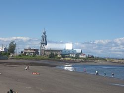
Sainte-Luce, Quebec
Sainte-Luce | |
|---|---|
 Coast of Sainte-Luce | |
| Motto: Une communauté unie et épanouie | |
 Location within La Mitis RCM | |
| Coordinates: 48°33′N 68°23′W / 48.55°N 68.38°W[1] | |
| Country | |
| Province | |
| Region | Bas-Saint-Laurent |
| RCM | La Mitis |
| Constituted | August 29, 2001 |
| Government | |
| • Mayor | Micheline Barriault |
| • Federal riding | Avignon—La Mitis—Matane—Matapédia |
| • Prov. riding | Matane-Matapédia |
| Area | |
• Total | 71.90 km2 (27.76 sq mi) |
| • Land | 72.59 km2 (28.03 sq mi) |
| There is an apparent contradiction between two authoritative sources | |
| Elevation | 75 m (246 ft) |
| Population | |
• Total | 2,845 |
| • Density | 39.2/km2 (102/sq mi) |
| • Pop 2016-2021 | |
| • Dwellings | 1,462 |
| Time zone | UTC−5 (EST) |
| • Summer (DST) | UTC−4 (EDT) |
| Postal code(s) | |
| Area code(s) | 418 and 581 |
| Highways | |
| Website | www |
Sainte-Luce (French pronunciation: [sɛ̃t lys]) is a municipality in the La Mitis Regional County Municipality in the Bas-Saint-Laurent region of Quebec, Canada. The population in the Canada 2021 Census was 2,845.[2][3]
History
The territory was known as of 1829 as the parish of Sainte-Luce, which was established in 1835. It became a municipality in 1855, but this same municipality had been created 1845 under the name of Lessard, for the name of the seigneurie which existed during the 16th century.

The name of Sainte-Luce was given in honour of Luce-Gertrude Drapeau (1794–1880), wife of the local notary, Thomas Casault, one the persons that established the seigneurie when the parish was canonized. The patron saint was Saint Lucy.
In 1918, the municipality of the village of Luceville was created from the territory of Sainte-Luce. Because it had one of the nicest beaches in the area, it had the nickname of Sainte-Luce-sur-Mer. The name of Luceville now identifies with the former municipality of the same name.
On August 29, 2001 the village of Luceville merged with the parish municipality of Sainte-Luce to form the municipality of Sainte-Luce–Luceville; the name was changed to simply Sainte-Luce on April 27, 2002.[4]
Geography
The many streams that flow through the municipality are part of the drainage basin of the Estuary of St. Lawrence.
Climate
Sainte-Luce has a humid continental climate (Köppen Dfb). The average annual temperature in Sainte-Luce is 3.9 °C (39.0 °F). The average annual precipitation is 931.7 mm (36.68 in) with October as the wettest month. The temperatures are highest on average in July, at around 17.9 °C (64.2 °F), and lowest in January, at around −11.3 °C (11.7 °F). The highest temperature ever recorded in Sainte-Luce was 35.9 °C (96.6 °F) on 4 July 1983; the coldest temperature ever recorded was −34.7 °C (−30.5 °F) on 3 January 2014.
| Climate data for Sainte-Luce | |||||||||||||
|---|---|---|---|---|---|---|---|---|---|---|---|---|---|
| Month | Jan | Feb | Mar | Apr | May | Jun | Jul | Aug | Sep | Oct | Nov | Dec | Year |
| Record high °C (°F) | 13.3 (55.9) |
12.4 (54.3) |
23.3 (73.9) |
29.1 (84.4) |
33.7 (92.7) |
35.1 (95.2) |
35.9 (96.6) |
35.1 (95.2) |
32.6 (90.7) |
26.7 (80.1) |
23.3 (73.9) |
16.7 (62.1) |
35.9 (96.6) |
| Mean daily maximum °C (°F) | −7.2 (19.0) |
−6.2 (20.8) |
−0.9 (30.4) |
6.0 (42.8) |
14.0 (57.2) |
19.8 (67.6) |
22.9 (73.2) |
22.1 (71.8) |
17.3 (63.1) |
9.7 (49.5) |
3.5 (38.3) |
−2.9 (26.8) |
8.2 (46.8) |
| Daily mean °C (°F) | −11.3 (11.7) |
−10.3 (13.5) |
−4.9 (23.2) |
2.0 (35.6) |
9.0 (48.2) |
14.6 (58.3) |
17.9 (64.2) |
17.1 (62.8) |
12.7 (54.9) |
6.1 (43.0) |
0.4 (32.7) |
−6.2 (20.8) |
3.9 (39.0) |
| Mean daily minimum °C (°F) | −15.4 (4.3) |
−14.4 (6.1) |
−8.9 (16.0) |
−1.9 (28.6) |
3.9 (39.0) |
9.2 (48.6) |
12.9 (55.2) |
12.1 (53.8) |
8.0 (46.4) |
2.5 (36.5) |
−2.8 (27.0) |
−9.6 (14.7) |
−0.4 (31.3) |
| Record low °C (°F) | −34.7 (−30.5) |
−31.1 (−24.0) |
−29.4 (−20.9) |
−19.9 (−3.8) |
−12.2 (10.0) |
−1.1 (30.0) |
0.8 (33.4) |
1.8 (35.2) |
−5.0 (23.0) |
−8.4 (16.9) |
−18.3 (−0.9) |
−30.6 (−23.1) |
−34.7 (−30.5) |
| Average precipitation mm (inches) | 74.0 (2.91) |
65.0 (2.56) |
70.0 (2.76) |
64.0 (2.52) |
75.5 (2.97) |
76.1 (3.00) |
92.5 (3.64) |
77.5 (3.05) |
85.7 (3.37) |
97.0 (3.82) |
73.7 (2.90) |
80.6 (3.17) |
931.7 (36.68) |
| Source: Environment Canada (based on the Mont-Joli station)[5] | |||||||||||||
See also
References
- ^ "Banque de noms de lieux du Québec: Reference number 368192". toponymie.gouv.qc.ca (in French). Commission de toponymie du Québec.
- ^ a b c "Répertoire des municipalités: Geographic code 09092". www.mamh.gouv.qc.ca (in French). Ministère des Affaires municipales et de l'Habitation.
- ^ a b c "Census Profile, 2021 Census, Statistics Canada - Validation Error".
- ^ "Archived copy" (PDF). stat.gouv.qc.ca. Archived from the original (PDF) on 30 December 2006. Retrieved 30 June 2022.
{{cite web}}: CS1 maint: archived copy as title (link) - ^ Cite error: The named reference
climatewas invoked but never defined (see the help page).
External links
 Media related to Sainte-Luce, Quebec at Wikimedia Commons
- Official website


