
Portal:World
The World Portal


The world is the totality of entities, the whole of reality, or everything that exists. The nature of the world has been conceptualized differently in different fields. Some conceptions see the world as unique, while others talk of a "plurality of worlds". Some treat the world as one simple object, while others analyze the world as a complex made up of parts.
In scientific cosmology, the world or universe is commonly defined as "the totality of all space and time; all that is, has been, and will be". Theories of modality talk of possible worlds as complete and consistent ways how things could have been. Phenomenology, starting from the horizon of co-given objects present in the periphery of every experience, defines the world as the biggest horizon, or the "horizon of all horizons". In philosophy of mind, the world is contrasted with the mind as that which is represented by the mind.
Theology conceptualizes the world in relation to God, for example, as God's creation, as identical to God, or as the two being interdependent. In religions, there is a tendency to downgrade the material or sensory world in favor of a spiritual world to be sought through religious practice. A comprehensive representation of the world and our place in it, as is found in religions, is known as a worldview. Cosmogony is the field that studies the origin or creation of the world, while eschatology refers to the science or doctrine of the last things or of the end of the world.
In various contexts, the term "world" takes a more restricted meaning associated, for example, with the Earth and all life on it, with humanity as a whole, or with an international or intercontinental scope. In this sense, world history refers to the history of humanity as a whole, and world politics is the discipline of political science studying issues that transcend nations and continents. Other examples include terms such as "world religion", "world language", "world government", "world war", "world population", "world economy", or "world championship". (Full article...)
Selected articles -


Gerardus Mercator 1512–1594
The Mercator world map of 1569 is titled Nova et Aucta Orbis Terrae Descriptio ad Usum Navigantium Emendate Accommodata (Renaissance Latin for "New and more complete representation of the terrestrial globe properly adapted for use in navigation"). The title shows that Gerardus Mercator aimed to present contemporary knowledge of the geography of the world and at the same time 'correct' the chart to be more useful to sailors. This 'correction', whereby constant bearing sailing courses on the sphere (rhumb lines) are mapped to straight lines on the plane map, characterizes the Mercator projection. While the map's geography has been superseded by modern knowledge, its projection proved to be one of the most significant advances in the history of cartography, inspiring the 19th century map historian Adolf Nordenskiöld to write "The master of Rupelmonde stands unsurpassed in the history of cartography since the time of Ptolemy." The projection heralded a new era in the evolution of navigation maps and charts and it is still their basis.The map is inscribed with a great deal of text. The framed map legends (or cartouches) cover a wide variety of topics: a dedication to his patron and a copyright statement; discussions of rhumb lines; great circles and distances; comments on some of the major rivers; accounts of fictitious geography of the north pole and the southern continent. The full Latin texts and English translations of all the legends are given below. Other minor texts are sprinkled about the map. They cover such topics as the magnetic poles, the prime meridian, navigational features, minor geographical details, the voyages of discovery and myths of giants and cannibals. These minor texts are also given below. (Full article...)
Painting of a turn-of-century trading fair, Hessisches Volksfest (Hessian Folk Festival), 1887, Louis Toussaint (1826–1887), Öl auf Leinwand
Cultural globalization refers to the transmission of ideas, meanings and values around the world in such a way as to extend and intensify social relations. This process is marked by the common consumption of cultures that have been diffused by the Internet, popular culture media, and international travel. This has added to processes of commodity exchange and colonization which have a longer history of carrying cultural meaning around the globe. The circulation of cultures enables individuals to partake in extended social relations that cross national and regional borders. The creation and expansion of such social relations is not merely observed on a material level. Cultural globalization involves the formation of shared norms and knowledge with which people associate their individual and collective cultural identities. It brings increasing interconnectedness among different populations and cultures. The idea of cultural globalization emerged in the late 1980s, but was diffused widely by Western academics throughout the 1990s and early 2000s. For some researchers, the idea of cultural globalization is reaction to the claims made by critics of cultural imperialism in the 1970s and 1980s. (Full article...)- The Vendée Globe is a single-handed (solo) non-stop, unassisted round the world yacht race. The race was founded by Philippe Jeantot in 1989, and since 1992 has taken place every four years. It is named after the Département of Vendée, in France, where the race starts and ends. The Vendée Globe is considered an extreme quest of individual endurance and the ultimate test in ocean racing. (Full article...)

The Space Race (Russian: космическая гонка, romanized: kosmicheskaya gonka, IPA: [kɐsˈmʲitɕɪskəjə ˈɡonkə]) was a 20th-century competition between the Cold War rivals, the United States and the Soviet Union, to achieve superior spaceflight capability. It had its origins in the ballistic missile-based nuclear arms race between the two nations following World War II and the onset of the cold war. The technological advantage demonstrated by spaceflight achievement was seen as necessary for national security, particularly in regard to intercontinental ballistic missile and satellite reconnaissance capability, but also became part of the cultural symbolism and ideology of the time. The Space Race brought pioneering launches of artificial satellites, robotic landers to the Moon, Venus, and Mars, and human spaceflight in low Earth orbit and ultimately to the Moon.
Public interest in space travel originated in the 1951 publication of a Soviet youth magazine and was promptly picked up by US magazines. The competition began on July 30, 1955, when the United States announced its intent to launch artificial satellites for the International Geophysical Year. Four days later, the Soviet Union responded by declaring they would also launch a satellite "in the near future". The launching of satellites was enabled by developments in ballistic missile capabilities since the end of World War II. The competition gained Western public attention with the "Sputnik crisis", when the USSR achieved the first successful satellite launch, Sputnik 1, on October 4, 1957. It gained momentum when the USSR sent the first human, Yuri Gagarin, into space with the orbital flight of Vostok 1 on April 12, 1961. These were followed by a string of other firsts achieved by the Soviets over the next few years. (Full article...)
The International Monetary Fund (IMF) is a major financial agency of the United Nations, and an international financial institution funded by 191 member countries, with headquarters in Washington, D.C. It is regarded as the global lender of last resort to national governments, and a leading supporter of exchange-rate stability. Its stated mission is "working to foster global monetary cooperation, secure financial stability, facilitate international trade, promote high employment and sustainable economic growth, and reduce poverty around the world."
Established in July 1944 at the Bretton Woods Conference, primarily according to the ideas of Harry Dexter White and John Maynard Keynes, it started with 29 member countries and the goal of reconstructing the international monetary system after World War II. In its early years, the IMF primarily focused on facilitating fixed exchange rates across the developed world. It now plays a central role in the management of balance of payments difficulties and international financial crises. Through a quota system, countries contribute funds to a pool from which countries can borrow if they experience balance of payments problems. The IMF works to stabilize and foster the economies of its member countries by its use of the fund, as well as other activities such as gathering and analyzing economic statistics and surveillance of its members' economies. (Full article...)
Early in the COVID-19 pandemic, convention centers (pictured here) were deemed to be ideal sites for temporary hospitals, due to their existing infrastructure (electrical, water, sewage). Hotels and dormitories were also considered appropriate because they can use negative pressure technology.
A pandemic (/pænˈdɛmɪk/ pan-DEM-ik) is an epidemic of an infectious disease that has a sudden increase in cases and spreads across a large region, for instance multiple continents or worldwide, affecting a substantial number of individuals. Widespread endemic diseases with a stable number of infected individuals such as recurrences of seasonal influenza are generally excluded as they occur simultaneously in large regions of the globe rather than being spread worldwide.
Throughout human history, there have been a number of pandemics of diseases such as smallpox. The Black Death, caused by the Plague, caused the deaths of up to half of the population of Europe in the 14th century. The term pandemic had not been used then, but was used for later epidemics, including the 1918 H1N1 influenza A pandemic—more commonly known as the Spanish flu—which is the deadliest pandemic in history. The most recent pandemics include the HIV/AIDS pandemic, the 2009 swine flu pandemic and the COVID-19 pandemic. Almost all these diseases still circulate among humans though their impact now is often far less. (Full article...)- The Paris Agreement (also called the Paris Accords or Paris Climate Accords) is an international treaty on climate change that was signed in 2016. The treaty covers climate change mitigation, adaptation, and finance. The Paris Agreement was negotiated by 196 parties at the 2015 United Nations Climate Change Conference near Paris, France. As of February 2023, 195 members of the United Nations Framework Convention on Climate Change (UNFCCC) are parties to the agreement. Of the three UNFCCC member states which have not ratified the agreement, the only major emitter is Iran. The United States, the second largest emitter, withdrew from the agreement in 2020, rejoined in 2021, and announced its withdrawal again in 2025.
The Paris Agreement has a long-term temperature goal which is to keep the rise in global surface temperature to well below 2 °C (3.6 °F) above pre-industrial levels. The treaty also states that preferably the limit of the increase should only be 1.5 °C (2.7 °F). These limits are defined as averages of the global temperature as measured over many years. (Full article...)


General images -

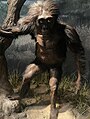 Model of a Australopithecus afarensis at the Smithsonian National Museum of Natural History. This reconstruction depicts the facultative bipedalism hypothesis, indicated by the use of the tree for stabilization. (from Human history)
 COVID-19 pandemic, 2020 (from Human history)
 Carving of Persian and Median soldiers, Persepolis, Achaemenid Empire, 5th century BCE
 A reconstruction of human history based on fossil data. (from History of Earth)
 Artist's impression of the enormous collision that probably formed the Moon (from History of Earth)
 Image of the physical world, captured by the Hubble Space Telescope (from World)
 An artist's rendering of a protoplanetary disk (from History of Earth)
 Empires of the world in 1898
 Graph showing range of estimated partial pressure of atmospheric oxygen through geologic time (from History of Earth)
 European migrations by mostly Germanic peoples, 2nd–6th centuries (from Human history)
 Artist's conception of Devonian flora (from History of Earth)
 A banded iron formation from the 3.15 Ga Moodies Group, Barberton Greenstone Belt, South Africa. Red layers represent the times when oxygen was available; gray layers were formed in anoxic circumstances. (from History of Earth)
 Taj Mahal, Mughal Empire, India
 Earth's history with time-spans of the eons to scale. Ma means "million years ago". (from History of Earth)
 A view of Earth with different layers of its atmosphere visible: the troposphere with its clouds casting shadows, a band of stratospheric blue sky at the horizon, and a line of green airglow of the lower thermosphere around an altitude of 100 km, at the edge of space (from Earth)

 A reconstruction of Pannotia (550 Ma). (from History of Earth)
 Ming dynasty section, Great Wall of China
 Japanese depiction of a Portuguese carrack, a result of globalizing maritime trade
 Chloroplasts in the cells of a moss (from History of Earth)
 Cross-section through a liposome (from History of Earth)
 A view of Earth with its global ocean and cloud cover, which dominate Earth's surface and hydrosphere; at Earth's polar regions, its hydrosphere forms larger areas of ice cover. (from Earth)
 Machu Picchu, Inca Empire, Peru
 Trilobites first appeared during the Cambrian period and were among the most widespread and diverse groups of Paleozoic organisms. (from History of Earth)
 A composite image of Earth, with its different types of surface discernible: Earth's surface dominating Ocean (blue), Africa with lush (green) to dry (brown) land and Earth's polar ice in the form of Antarctic sea ice (grey) covering the Antarctic or Southern Ocean and the Antarctic ice sheet (white) covering Antarctica. (from Earth)
 Earth's axial tilt causing different angles of seasonal illumination at different orbital positions around the Sun (from Earth)
 Shanghai. China urbanized rapidly in the 21st century.
 Artist's impression of Earth during the later Archean, the largely cooled planetary crust and water-rich barren surface, marked by volcanoes and continents, features already round microbialites. The Moon, still orbiting Earth much closer than today and still dominating Earth's sky, produced strong tides. (from History of Earth)
 The replicator in virtually all known life is deoxyribonucleic acid. DNA is far more complex than the original replicator and its replication systems are highly elaborate. (from History of Earth)
 Geologic map of North America, color-coded by age. From most recent to oldest, age is indicated by yellow, green, blue, and red. The reds and pinks indicate rock from the Archean.
 Lithified stromatolites on the shores of Lake Thetis, Western Australia. Archean stromatolites are the first direct fossil traces of life on Earth. (from History of Earth)
 Fall of the Berlin Wall, 1989
 Olmec colossal head, now at the Museo de Antropología de Xalapa
 A schematic view of Earth's magnetosphere with solar wind flowing from left to right (from Earth)
 Notre-Dame de Paris, France
 Chennakesava Temple, Belur, India
 Successive dispersals of Homo erectus (yellow), Homo neanderthalensis (ochre) during Out of Africa I and Homo sapiens (red, Out of Africa II), with the numbers of years since they appeared before present. (from Human history)
 Earth's land use for human agriculture in 2019 (from Earth)
 Artist's rendition of an oxinated fully-frozen Snowball Earth with no remaining liquid surface water. (from History of Earth)
 Last Moon landing: Apollo 17 (1972)
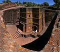 One of the eleven Rock-hewn Churches of Lalibela constructed during the Zagwe dynasty in Ethiopia (from Human history)
 Benin Bronze head from Nigeria
 Pale orange dot, an artist's impression of Early Earth, featuring its tinted orange methane-rich early atmosphere (from Earth)
 Pangaea was a supercontinent that existed from about 300 to 180 Ma. The outlines of the modern continents and other landmasses are indicated on this map. (from History of Earth)
 Cuneiform inscription, eastern Turkey
- The pale orange dot, an artist's impression of the early Earth which might have appeared orange through its hazy methane rich prebiotic second atmosphere. Earth's atmosphere at this stage was somewhat comparable to today's atmosphere of Titan. (from History of Earth)
 Tracy Caldwell Dyson, a NASA astronaut, observing Earth from the Cupola module at the International Space Station on 11 September 2010 (from Earth)
 Artist's conception of Hadean Eon Earth, when it was much hotter and inhospitable to all forms of life. (from History of Earth)
 The first airplane, the Wright Flyer, flew on 17 December 1903.
 A computer-generated image mapping the prevalence of artificial satellites and space debris around Earth in geosynchronous and low Earth orbit (from Earth)
- An artist's impression of the Archean, the eon after Earth's formation, featuring round stromatolites, which are early oxygen-producing forms of life from billions of years ago. After the Late Heavy Bombardment, Earth's crust had cooled, its water-rich barren surface is marked by continents and volcanoes, with the Moon still orbiting Earth half as far as it is today, appearing 2.8 times larger and producing strong tides. (from Earth)
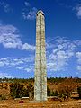 Obelisk of Axum, Ethiopia
 Pillar erected by Ashoka, a Mauryan Emperor in India
 Great Pyramids of Giza, Egypt
 13th-century French historiated initial with the three classes of medieval society: those who prayed (the clergy), those who fought (the knights), and those who worked (the peasantry)
 Earth's western hemisphere showing topography relative to Earth's center instead of to mean sea level, as in common topographic maps (from Earth)
 Portrait of Alfraganus in the Compilatio astronomica, 1493. Islamic astronomers began just before the 9th century to collect and translate Indian, Persian and Greek astronomical texts, adding their own astronomy and enabling later, particularly European astronomy to build on. Symbolic for the post-classical period, a period of an increasing trans-regional literary culture, particularly in the sciences, spreading and building on methods of science. (from Human history)
 Yggdrasil, an attempt to reconstruct the Norse world tree which connects the heavens, the world, and the underworld. (from World)
 Dinosaurs were the dominant terrestrial vertebrates throughout most of the Mesozoic (from History of Earth)
 Earth's night-side upper atmosphere appearing from the bottom as bands of afterglow illuminating the troposphere in orange with silhouettes of clouds, and the stratosphere in white and blue. Next the mesosphere (pink area) extends to the orange and faintly green line of the lowest airglow, at about one hundred kilometers at the edge of space and the lower edge of the thermosphere (invisible). Continuing with green and red bands of aurorae stretching over several hundred kilometers. (from Earth)
 Satellite time lapse imagery of Earth's rotation showing axis tilt (from Earth)
 Tiktaalik, a fish with limb-like fins and a predecessor of tetrapods. Reconstruction from fossils about 375 million years old. (from History of Earth)
 Angkor Wat temple complex, Cambodia, early 12th century
 A composite image of artificial light emissions at night on a map of Earth (from Earth)
 A 2012 artistic impression of the early Solar System's protoplanetary disk from which Earth and other Solar System bodies were formed (from Earth)
 Florence, birthplace of the Italian Renaissance
 Battle during the 1281 Mongol invasion of Japan
 A 580 million year old fossil of Spriggina floundensi, an animal from the Ediacaran period. Such life forms could have been ancestors to the many new forms that originated in the Cambrian Explosion. (from History of Earth)
 An artist's impression of ice age Earth at glacial maximum. (from History of Earth)
 Standing Buddha from Gandhara, 2nd century CE
 Vitruvian Man by Leonardo da Vinci epitomizes the advances in art and science seen during the Renaissance. (from History of Earth)
 Change in average surface air temperature and drivers for that change. Human activity has caused increased temperatures, with natural forces adding some variability. (from Earth)
 A map of heat flow from Earth's interior to the surface of Earth's crust, mostly along the oceanic ridges (from Earth)
 An animation of the changing density of productive vegetation on land (low in brown; heavy in dark green) and phytoplankton at the ocean surface (low in purple; high in yellow) (from Earth)
 Artist's impression of a Hadean landscape with the relatively newly formed Moon still looming closely over Earth and both bodies sustaining strong volcanism. (from History of Earth)
 A pillar at Neolithic Göbekli Tepe


Megacities of the world -

São Paulo (/ˌsaʊ ˈpaʊloʊ/, Portuguese: [sɐ̃w ˈpawlu] ⓘ; Portuguese for 'Saint Paul') is the capital of the state of São Paulo, as well as the most populous city in Brazil and South America. Listed by the Globalization and World Cities Research Network (GaWC) as an alpha global city, it exerts substantial international influence in commerce, finance, arts, and entertainment. It is the largest urban area by population outside Asia and the most populous Portuguese-speaking city in the world. The city's name honors Paul the Apostle and people from the city are known as paulistanos. The city's Latin motto is Non ducor, duco, which translates as "I am not led, I lead."
Founded in 1554 by Jesuit priests, the city was the center of the bandeirantes settlers during Colonial Brazil, but it became a relevant economic force only during the Brazilian coffee cycle in the mid-19th century and later consolidated its role as the main national economic hub with industrialization in Brazil in the 20th century, which made the city a cosmopolitan melting pot, home to the largest Arab, Italian, and Japanese diasporas in the world, with ethnic neighborhoods like Bixiga, Bom Retiro, and Liberdade, and people from more than 200 other countries. The city's metropolitan area, Greater São Paulo, is home to more than 20 million inhabitants and ranks as the most populous in Brazil and one of the most populous in the world. The process of conurbation between the metropolitan areas around Greater São Paulo also created the São Paulo Macrometropolis, the first megalopolis in the Southern Hemisphere, with more than 30 million inhabitants. (Full article...)
Did you know -

- ... that during World War II, Leonard K. Carson led an air combat school within his fighter unit, called "Clobber College"?
- ... that the solar water-heating market in Turkey is second in the world, after China's?
- ... that Boston's World's Museum was a theatre, an aquarium, a menagerie, and a freak show?
- ... that Harrogate War Memorial, by Ernest Prestwich, names 1163 casualties of the First and Second World Wars, of whom more than 300 have unknown graves, and the youngest was 15 years old?
- ... that a future World War II aircraft carrier was used as a hotel during the 7th National Eucharistic Congress in 1935?
- ... that in 2022, Briton Charlotte Payne broke the world record for a hammer throw by a deaf woman by almost 5 metres (16 ft)?
- ... that Carver Court in Coatesville, Pennsylvania, was built to house African-American steelworkers during World War II?
- ... that the play-by-mail game Westworld was run from prison?
Countries of the world -

Australia, officially the Commonwealth of Australia, is a country comprising the mainland of the Australian continent, the island of Tasmania and numerous smaller islands. It has a total area of 7,688,287 km2 (2,968,464 sq mi), making it the sixth-largest country in the world and the largest in Oceania. Australia is the world's flattest and driest inhabited continent. It is a megadiverse country, and its size gives it a wide variety of landscapes and climates including deserts in the interior and tropical rainforests along the coast.
The ancestors of Aboriginal Australians began arriving from south-east Asia 50,000 to 65,000 years ago, during the last glacial period. By the time of British settlement, Aboriginal Australians spoke 250 distinct languages and had one of the oldest living cultures in the world. Australia's written history commenced with Dutch exploration of most of the coastline in the 17th-century. British colonisation began in 1788 with the establishment of the penal colony of New South Wales. By the mid-19th century, most of the continent had been explored by European settlers and five additional self-governing British colonies were established, each gaining responsible government by 1890. The colonies federated in 1901, forming the Commonwealth of Australia. This continued a process of increasing autonomy from the United Kingdom, highlighted by the Statute of Westminster Adoption Act 1942, and culminating in the Australia Acts of 1986. (Full article...)

Various lists of the Wonders of the World have been compiled from antiquity to the present day, in order to catalogue the world's most spectacular natural features and human-built structures.
The Seven Wonders of the Ancient World is the oldest known list of this type, documenting the most iconic and remarkable human-made creations of classical antiquity; it was based on guidebooks popular among Hellenic sightseers and as such only includes works located around the Mediterranean rim and in the ancient Near East. The number seven was chosen because the Greeks believed it represented perfection and plenty, and because it reflected the number of planets known in ancient times (five) plus the Sun and Moon. (Full article...)
Related portals
Protected areas of the world -
- This is a list of protected areas of Ontario that are administered by Government of Ontario. Ontario Parks and the Ministry of the Environment, Conservation and Parks are the provincial bodies responsible for managing these protected areas. (Full article...)
- The protected areas of South Africa include national parks and marine protected areas managed by the national government, public nature reserves managed by provincial and local governments, and private nature reserves managed by private landowners. Most protected areas are intended for the conservation of flora and fauna. National parks are maintained by South African National Parks (SANParks). A number of national parks have been incorporated in transfrontier conservation areas.
Protected areas may also be protected for their value and importance as historical, cultural heritage or scientific sites. More information on these can be found in the list of heritage sites in South Africa. (Full article...) 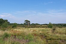
Heathland at the Hoge Kempen National Park
There are numerous protected areas in Belgium with a wide variety of types, protection levels and sizes. The below list gives an overview of the most important protected areas. (Full article...)
Vegetation outside Goz Beïda
The wildlife of Chad is composed of its flora and fauna. West African lions, buffalo, hippopotamuses, Kordofan giraffes, antelopes, African leopards, cheetahs, hyenas, Bush elephants, and many species of snakes are found there, although most large carnivore populations have been drastically reduced since the early 20th century. Elephant poaching, particularly in the south of the country in areas such as Zakouma National Park, is a severe problem. (Full article...)- The following list of protected areas of British Columbia includes all federally and provincially protected areas within the Canadian province of British Columbia. As of 2015, approximately 15.46% of the province's land area and 3.17% of the province's waters are protected. (Full article...)

Part of the Brecon Beacons National Park, looking from the highest point of Pen y Fan (886 m/2907 feet) to Cribyn (795 m/2608 feet).
Protected areas of the United Kingdom are areas in the United Kingdom which need and /or receive protection because of their environmental, historical or cultural value to the nation. Methods and aims of protection vary depending on the nature and importance of the resource. Protection operates at local, regional, national and international levels, and may be backed by legislation and international treaty, or less formally by planning policy.
Within the United Kingdom, different approaches are taken to some forms of protection within the constituent countries of England, Scotland, Wales and Northern Ireland, while other forms of protection are more consistent across the UK. Protected areas can be divided according to the type of resource which each seeks to protect. Primarily, these are: scenic or landscape value; biodiversity value (species and habitats); geodiversity value (relating to geology and geomorphology); and cultural or historic value. Several types of protected areas are focused on more than one of these areas. (Full article...)
A view at Kintrishi National Park
The South Caucasian nation of Georgia is home to several protected areas, which receive protection because of their environmental, cultural or similar value. The oldest of these – now known as the Lagodekhi Protected Areas – dates back to 1912, when Georgia was part of the Russian Empire.
The total area of Georgia's protected terrestrial territories is 6,501 km2 (2,510 sq mi), which amounts to approximately 9.29% of the country's territory. In addition 153 km2 (59 sq mi) of marine area protected, or 0.67% of the country's territorial waters. There are a total of 89 protected areas, including 14 Strict Nature Reserves, 12 National Parks, 20 Managed Nature Reserves, 40 Natural Monuments, 2 Ramsar sites and 1 Protected Landscape. Strict nature reserves comprise 140,672 ha, while national parks cover 276,724 ha. The total number of visitors to Georgia's protected areas was just under 1.2 million in 2019. (Full article...)- Protected areas of Estonia are regulated by the Nature Conservation Act (Estonian: Looduskaitseseadus), which was passed by the Estonian parliament on April 21, 2004 and entered into force May 10, 2004.
Overall Estonia has 15403 protected areas covering 21% of the country land and 18% of it marine and coastal territory, including 6 national parks: Lahemaa National Park, Karula National Park, Soomaa National Park,Vilsandi National Park, Matsalu National Park, and Alutaguse National Park (Full article...) - Protected areas of Slovenia include one national park (Slovene: narodni park), three regional parks (regijski park), several natural parks (krajinski park), and hundreds of natural monuments (naravni spomenik) and monuments of designed nature (spomenik oblikovane narave). They cover about 12.5% of the Slovenian territory. Under the Wild Birds Directive, 26 sites totalling roughly 25% of the nation's land are "Special Protected Areas"; the Natura 2000 proposal would increase the totals to 260 sites and 32% of national territory. (Full article...)

In the Philippines, protected areas are administered by the Biodiversity Management Bureau of the Department of Environment and Natural Resources (DENR) under the National Integrated Protected Areas System (NIPAS) Act of 1992.
As of 2020, there are 244 protected areas in the Philippines, covering a total area of about 7,760,000 hectares (19,200,000 acres) – 15.4% of the Philippines' total area. (Full article...)- Kentucky's system of 44 state parks has been referred to as "the nation's finest" and experiences more repeat business annually than those of any other U.S. state. The state's diverse geography provides a variety of environments to experience. From mountain lakes to expansive caves to forests teeming with wildlife, park-goers have their choice of attractions, and they are all within a day's drive of each other.
Unless otherwise specified, data in the following lists are taken from Kentucky State Parks by Bill Bailey. (Full article...) 
Viru bog in Lahemaa National Park
Protected areas in Estonia are national parks, nature reserves and landscape protection areas (nature parks).
Estonia has five national parks, 167 nature reserves and 152 landscape conservation areas. In addition, there are 116 (118) protected areas with an old (Soviet-era) protection regulation and 537 parks. In total, 18.1% of Estonia are protected nature areas, with Lääne County having the highest percentage (32%) and Põlva County the lowest percentage of protected areas, about 9%. (Full article...)- Protected areas of Norway include:
About 17 percent of the mainland of Norway is protected. Of this, ca. 8.3 percent is national parks, 1.3 percent is nature reserves and 4.7 percent otherwise protected. (Full article...) 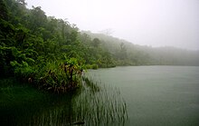
Upolu Island, Samoa
This is a list of some protected areas of Samoa which include national parks, reservations, protected nature zones, marine reserves and other areas of significant biodiversity and conservation.
In 1994, Samoa ratified the international and legally binding treaty, the Convention on Biological Diversity to develop national strategies for conservation and sustainable use of biological diversity. In 2010, protected areas in the country cover 5% of land although the government aims to increase protected areas coverage to 15%. (Full article...)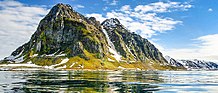
The northernmost tip of Prins Karls Forland in Forlandet National Park
Svalbard is an Arctic wilderness archipelago comprising the northernmost part of Norway. There are twenty-nine protected natural areas, consisting of seven national parks, six nature reserves, fifteen bird sanctuaries and one geotope protected area. In addition, human traces dating from before 1946 are automatically protected. The protected areas make up 39,800 square kilometers (15,400 sq mi) or 65% of the land area, and 78,000 square kilometers (30,000 sq mi) or 86.5% of the territorial waters. The largest protected areas are Nordaust-Svalbard Nature Reserve and Søraust-Svalbard Nature Reserve, which cover most of the areas east of the main island of Spitsbergen, including the islands of Nordaustlandet, Edgeøya, Barentsøya, Kong Karls Land and Kvitøya. Six of the national parks are located on Spitsbergen. Ten of the bird sanctuaries and the Moffen Nature Reserve are located within national parks. Five of the bird sanctuaries are Ramsar sites and fourteen of the bird sanctuaries are islands. Svalbard is on Norway's tentative list for nomination as a UNESCO World Heritage Site.
The supreme responsibility for conservation lies with the Norwegian Ministry of the Environment, which has delegated the management to the Governor of Svalbard and the Norwegian Directorate for Nature Management. The foundation for conservation was established in the Svalbard Treaty of 1920, and has been further specified in the Svalbard Environmental Act of 2001. The first round of protection took force on 1 July 1973, when most of the current protected areas came into effect. This included the two large nature reserves and three of the national parks. Moffen Nature Reserve was established in 1983, followed by four national parks, three nature reserves and one geotope protection area between 2002 and 2005. (Full article...)


Selected world maps
 Mollweide projection of the world
 The world map by Gerardus Mercator (1569), the first map in the well-known Mercator projection
 Index map from the International Map of the World (1:1,000,000 scale)
 Only a few of the largest large igneous provinces appear (coloured dark purple) on this geological map, which depicts crustal geologic provinces as seen in seismic refraction data
 United Nations Human Development Index map by country (2016)
 The Goode homolosine projection is a pseudocylindrical, equal-area, composite map projection used for world maps.
 1516 map of the world by Martin Waldseemüller
 A plate tectonics map with volcano locations indicated with red circles
 Time zones of the world


World records
- List of Olympic records in athletics
- List of world records in athletics
- List of junior world records in athletics
- List of world records in masters athletics
- List of world youth bests in athletics
- List of IPC world records in athletics
- List of world records in canoeing
- List of world records in chess
- List of cycling records
- List of world records in track cycling
- List of world records in finswimming
- List of world records in juggling
- List of world records in rowing
- List of world records in speed skating
- List of world records in swimming
- List of IPC world records in swimming
- List of world records in Olympic weightlifting
Topics

Continents of Earth | ||||||||
|---|---|---|---|---|---|---|---|---|
| ||||||||
| ||||||||
| ||||||||


| Cenozoic Era (present–66.0 Ma) |
| ||||||||||||
|---|---|---|---|---|---|---|---|---|---|---|---|---|---|
| Mesozoic Era (66.0–252 Ma) |
| ||||||||||||
| Paleozoic Era (252–539 Ma) |
| ||||||||||||
| Proterozoic Eon (539 Ma–2.5 Ga) |
| ||||||||||||
| Archean Eon (2.5–4 Ga) | |||||||||||||
| Hadean Eon (4–4.6 Ga) | |||||||||||||
ka = kiloannum (thousand years ago); Ma = megaannum (million years ago); Ga = gigaannum (billion years ago). See also: Geologic time scale • | |||||||||||||
| Locations | ||
|---|---|---|
| Related | ||

| |||||||||||||||||||
| |||||||||||||||||||
| |||||||||||||||||||
Economic classification of countries | |||||
|---|---|---|---|---|---|
| Three-World Model | |||||
| Gross domestic product (GDP) |
| ||||
| Gross national income (GNI) | |||||
| Wages | |||||
| Wealth | |||||
| Other national accounts | |||||
| Human development | |||||
| Digital divide | |||||
| Net international investment position (NIIP) | |||||
| Technological |
| ||||
|---|---|---|---|---|---|
| Sociological | |||||
| Ecological |
| ||||
| Biological |
| ||||
| Astronomical | |||||
| Eschatological |
| ||||
| Others |
| ||||
| Fictional | |||||
| Organizations | |||||
Categories

Wikimedia
The following Wikimedia Foundation sister projects provide more on this subject:
 Commons
Free media repository Wikibooks
Free textbooks and manuals Wikidata
Free knowledge base Wikinews
Free-content news Wikiquote
Collection of quotations Wikisource
Free-content library Wikispecies
Directory of species Wikiversity
Free learning tools Wikivoyage
Free travel guide Wiktionary
Dictionary and thesaurus


