Pinet, Hérault
Pinet | |
|---|---|
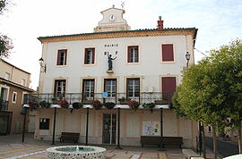
 Town hall | |
| Coordinates: 43°24′20″N 3°30′36″E / 43.4056°N 3.51°E | |
| Country | France |
| Region | Occitania |
| Department | Hérault |
| Arrondissement | Béziers |
| Canton | Pézenas |
| Intercommunality | CA Hérault Méditerranée |
| Government | |
| • Mayor (2021–2026) | Nicolas Isern[1] |
Area 1 | 8.83 km2 (3.41 sq mi) |
| Population (2022)[2] | 2,012 |
| • Density | 230/km2 (590/sq mi) |
| Time zone | UTC+01:00 (CET) |
| • Summer (DST) | UTC+02:00 (CEST) |
| INSEE/Postal code | 34203 /34850 |
| Elevation | 5–68 m (16–223 ft) (avg. 13 m or 43 ft) |
| 1 French Land Register data, which excludes lakes, ponds, glaciers > 1 km2 (0.386 sq mi or 247 acres) and river estuaries. | |
Pinet (French pronunciation: [pinɛ]) is a commune in the Hérault department in the Occitanie region in southern France.
Population

| Year | Pop. | ±% |
|---|---|---|
| 1962 | 806 | — |
| 1968 | 814 | +1.0% |
| 1975 | 805 | −1.1% |
| 1982 | 827 | +2.7% |
| 1990 | 904 | +9.3% |
| 1999 | 990 | +9.5% |
| 2008 | 1,300 | +31.3% |
Economy
AOP Picpoul de Pinet is the only white wine appellation in the Languedoc. Vineyards are situated on the low hills surrounding the Etang de Thau, and include six different villages. Annual production is around 8,000,000 litres (1,800,000 imp gal). The wine is named Picpoul de Pinet, but the grape variety is Piquepoul blanc. Cultivation covers about 1,400 hectares (3,500 acres), on mostly limestone-based soils.[3]
See also
References
- ^ "Répertoire national des élus: les maires". data.gouv.fr, Plateforme ouverte des données publiques françaises (in French). 9 August 2021.
- ^ "Populations de référence 2022" (in French). The National Institute of Statistics and Economic Studies. 19 December 2024.
- ^ https://wineanorak.com/2022/01/03/picpoul-de-pinet-a-languedoc-success-story-taking-a-step-forward-with-new-patience-wines/ [bare URL]


