Pentre Camp
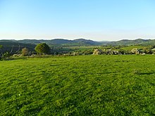
 View from the fort, looking north-east | |
| Location | Near Llangynyw, Wales |
|---|---|
| Coordinates | 52°40′36″N 3°18′24″W / 52.67667°N 3.30667°W |
| OS grid reference | SJ 117 096 |
| Type | Hillfort |
| Length | 74 metres (243 ft) |
| Width | 48 metres (157 ft) |
| Area | 0.8 acres (0.32 ha) |
| History | |
| Periods | Iron Age |
Pentre Camp is an Iron Age hillfort, near the hamlet of Llangynyw and about 2.5 miles (4 km) north-east of Llanfair Caereinion, in Powys, Wales. It is a scheduled monument.[1]
Description
The fort is an oval, about 74 metres (243 ft) by 48 metres (157 ft), enclosing an area of 0.8 acres (0.32 ha). There are several concentric ramparts: three in the north and west and five elsewhere. There are traces of further ramparts in the south and west.[1]
In the east the third and fourth ramparts are linked to form an entrance passage. All the banks are low, and may have originally been low, as foundations for timber defences.[1]
There is a spring (still issuing water) a short distance away, at the base of the northern slope of the fort; this was probably of practical importance in the fort's location.[1]
There is speculation that the field boundary wall crossing the northern rampart may be part of the original revetment.[1]

