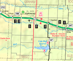
Ogallah, Kansas
Ogallah, Kansas | |
|---|---|
 | |
| Coordinates: 38°59′29″N 99°43′56″W / 38.99139°N 99.73222°W[1] | |
| Country | United States |
| State | Kansas |
| County | Trego |
| Founded | 1870s |
| Named for | Oglala Lakota tribe |
| Elevation | 2,336 ft (712 m) |
| Population | |
• Total | 28 |
| Time zone | UTC-6 (CST) |
| • Summer (DST) | UTC-5 (CDT) |
| ZIP code | 67656 |
| Area code | 785 |
| FIPS code | 20-52250 [1] |
| GNIS ID | 485296 [1] |
Ogallah is a census-designated place (CDP) in Trego County, Kansas, United States.[1] As of the 2020 census, the population was 28.[2] It is located approximately 7 miles east of WaKeeney.
History
Ogallah was named for the Oglala Lakota tribe.[3]
The post office was established January 27, 1879.[4]
Geography
Climate
The climate in this area is characterized by hot, humid summers and generally mild to cool winters. According to the Köppen Climate Classification system, Ogallah has a humid subtropical climate, abbreviated "Cfa" on climate maps.[5]
Demographics
| Census | Pop. | Note | %± |
|---|---|---|---|
| 2020 | 28 | — | |
| U.S. Decennial Census | |||
See also
References
- ^ a b c d e "Ogallah, Kansas", Geographic Names Information System, United States Geological Survey, United States Department of the Interior
- ^ a b "Profile of Ogallah, Kansas (CDP) in 2020". United States Census Bureau. Archived from the original on November 22, 2021. Retrieved November 22, 2021.
- ^ Heim, Michael (2007). Exploring Kansas Highways. p. 30. ISBN 9780974435886.
- ^ "Kansas Post Offices, 1828-1961". Kansas Historical Society. Archived from the original on October 9, 2013. Retrieved June 27, 2014.
- ^ Climate Summary for Ogallah, Kansas
Further reading
External links


