Nimigea
Nimigea | |
|---|---|
 Reformed church in Nimigea de Jos | |
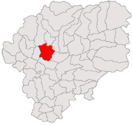
 Location in Bistrița-Năsăud County | |
| Coordinates: 47°15′9″N 24°18′3″E / 47.25250°N 24.30083°E | |
| Country | Romania |
| County | Bistrița-Năsăud |
| Subdivisions | Florești, Mintiu, Mititei, Mocod, Mogoșeni, Nimigea de Jos, Nimigea de Sus, Tăure |
| Government | |
| • Mayor (2020–2024) | Mircea-Gavrila Runcan (PSD) |
Area | 98.36 km2 (37.98 sq mi) |
| Elevation | 287 m (942 ft) |
| Population (2021-12-01)[1] | 5,434 |
| • Density | 55/km2 (140/sq mi) |
| Time zone | EET/EEST (UTC+2/+3) |
| Postal code | 427190 |
| Area code | +40 x59 |
| Vehicle reg. | BN |
| Website | nimigea |
Nimigea (Hungarian: Nemegye) is a commune in Bistrița-Năsăud County, Transylvania, Romania, with 5,324 residents. It is composed of eight villages: Florești (Virágosberek), Mintiu (Oláhnémeti), Mititei (Mittye), Mocod (Szamosmakód), Mogoșeni (Szamosmagasmart), Nimigea de Jos (the commune center; Magyarnemegye), Nimigea de Sus (Oláhnemegye), and Tăure (Tóhát).
The commune lies on the Transylvanian Plateau, at the confluence of the river Someșul Mare with its left tributary, the Bratoșa. It is located in the central-west part of the county, at a distance of 17 km (11 mi) from the town of Beclean and 28 km (17 mi) from the county seat, Bistrița.
At the 2011 census, 78% of inhabitants were Romanians, 13% Hungarians, and 6.6% Roma. 77.7% were Romanian Orthodox, 13.3% Reformed, and 5.5% Pentecostal.
Notable people
References
External links
- "International Jewish Cemetery Project – Nimigea de Sus: Bistrița County". iajgscemetery.org. International Association of Jewish Genealogical Societies. Retrieved January 4, 2022.
- Orthodox church in Nimigea de Jos
- Jewish cemetery in Nimigea de Jos
- Bridge over the river Bratoșa in Florești
- Nimigea train station


