Ludlow, Western Australia
| Ludlow Western Australia | |
|---|---|
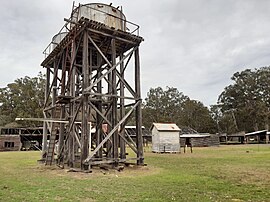
 The historic Ludlow Forestry Mill and Settlement | |
 | |
| Coordinates | 33°36′S 115°28′E / 33.600°S 115.467°E |
| Population | 132 (SAL 2021)[1] |
| Postcode(s) | 6280 |
| Area | 49.2 km2 (19.0 sq mi) |
| Time zone | AWST (UTC+8) |
| Location | |
| LGA(s) | |
| State electorate(s) | Vasse |
| Federal division(s) | Forrest |
| Designations | |
|---|---|
| Official name | Ludlow Forestry Mill and Settlement |
| Designated | 22 August 2006 |
| Reference no. | 15834 |
Ludlow is a locality in the South West region of Western Australia near the Tuart Forest National Park. It is in the local government areas of the City of Busselton and the Shire of Capel. At the 2021 census, the area had a population of 132.
History
The Wardandi people inhabited the Ludlow area before European settlement.[2] A school, Ludlow School (originally known as Ludlow Bridge School), existed in the area as early as 1866, but initially operated intermittently due to low patronage.[3]
A pine plantation was first set up at Ludlow in 1909,with a nursery being developed in 1916.[3] After the passage of the Forestry Act (1918), Conservator of Forests Charles Lane Poole set up a small forestry settlement in the area, along with the Ludlow Forestry School, the first such institution in Western Australia, which operated from 1921 to 1927.[2][3] During the 1920s the area was also part of the Group Settlement Scheme for dairy production, and a general store and district office were built, as well as a new school building for children in the Ludlow area.[3][4]
The first thinnings were harvested from the pine plantation in 1936/37 and by the early 1940s timber from Ludlow was being used to make cases and crates for food storage during World War II.[3] During the post-war housing boom, Ludlow was used to supply plywood for the housing industry. European immigrants ("New Australians") began working in the Ludlow pine plantation and by the mid-1950s a sawmill and planer mill, along with workers' cottages that formed the main Ludlow forestry settlement, had been constructed.[3] The settlement was divided by the Ludlow River; the north side, where most of the cottages were built, is in the area of the Shire of Capel.[5]
By the early 1970s the sawmill had been closed and plantings were discontinued in the pine plantation in 1973; the planer mill was closed a few years later.[3] The Tuart Forest National Park was declared in the area in 1987 and The Ludlow Forestry Mill and Settlement was registered on the State Register of Heritage Places in 2006.[5] In 2016 the Department of Parks and Wildlife, which rented out the cottages, evicted the occupants, citing maintenance issues, age, and housing conditions; the cottages have since been abandoned.[6] In 2021, the volunteer Ludlow Tuart Forest Restoration Group released a masterplan for a future forest education, research and tourist centre at the Ludlow forestry settlement.[7][8]
References
- ^ Australian Bureau of Statistics (28 June 2022). "Ludlow (suburb and locality)". Australian Census 2021 QuickStats. Retrieved 28 June 2022.
- ^ a b "Ludlow history". Ludlow Tuart Forest Restoration Group. Retrieved 11 August 2019.
- ^ a b c d e f g "Assessment Documentation: Ludlow Forestry Mill and Settlement" (PDF). Heritage Council of Western Australia. Retrieved 12 August 2019.
- ^ "Ruabon - Ludlow Settlers Memorial". Monuments Australia. Retrieved 15 August 2019.
- ^ a b "Ludlow Forestry Mill and Settlement". Heritage Council of Western Australia. Retrieved 15 August 2019.
- ^ Willix, Pierra (31 January 2017). "Ludlow tourism potential". Busselton Dunsborough Times. Retrieved 15 August 2019.
- ^ "Ludlow masterplan". Ludlow Tuart Forest Restoration Group. 21 December 2021. Retrieved 31 January 2022.
- ^ Verhagen, Shannon (23 June 2020). "Plans to turn historic Ludlow timber village into tourism precinct". South Western Times. Retrieved 31 January 2022.

