Lissett
| Lissett | |
|---|---|
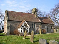
 St James Church, Lissett | |
Location within the East Riding of Yorkshire | |
| OS grid reference | TA144581 |
| • London | 170 mi (270 km) S |
| Civil parish | |
| Unitary authority | |
| Ceremonial county | |
| Region | |
| Country | England |
| Sovereign state | United Kingdom |
| Post town | DRIFFIELD |
| Postcode district | YO25 |
| Dialling code | 01262 |
| Police | Humberside |
| Fire | Humberside |
| Ambulance | Yorkshire |
| UK Parliament | |
Lissett is a village and former civil parish, now in the parish of Ulrome, in the Holderness area of the East Riding of Yorkshire, England. It is situated 6 miles (10 km) south of Bridlington town centre and 13 miles (21 km) north-east of Beverley town centre on the A165 road that connects the two towns. In 1931 the parish had a population of 95.[1]
In 1823 Lissett, with a population of 95, was in the parish of Beeford, and the Wapentake and Liberty of Holderness. A chapel of ease existed in the village.[2] Lissett was formerly a township and chapelry in the parish of Beeford,[3] from 1866 Lissett was a civil parish in its own right, on 1 April 1935 the parish was abolished and merged with Ulrome.[4]
In 1942 an RAF station, RAF Lissett, was built there. Its main role was to serve as a bomber airfield for the Halifax Bomber 158 Squadron. It had a short life - the final mission left the airbase on 25 April 1945. The airfield is now part of a small industrial estate in the village. In December 2008 a 30 MW[5] wind farm housing twelve turbines each 125 metres (410 ft) high was constructed across the western end of the airfield.[6]
The village church, St James, is a Grade II listed building and houses the oldest dated bell in England, dated 1254.[7] Perhaps of 14th-century origin, it was rebuilt by Hugh Roumieu Gough in 1876. Remaining from the previous church are fragments of a Norman capital in the east wall. The east stained glass window is by Charles Eamer Kempe, with Morris-style diamond-shaped flower details and lettering.[8]
References
- ^ "Population statistics Lissett Tn/CP through time". A Vision of Britain through Time. Retrieved 10 August 2023.
- ^ Baines, Edward (1823): History, Directory and Gazetteer of the County of York, p. 363
- ^ "History of Lissett, in East Riding of Yorkshire and East Riding". A Vision of Britain through Time. Retrieved 10 August 2023.
- ^ "Relationships and changes Lissett Tn/CP through time". A Vision of Britain through Time. Retrieved 5 February 2021.
- ^ "Our operations". Infinis. Archived from the original on 20 October 2013. Retrieved 21 October 2013.
- ^ "Lissett Airfield Wind Farm" (PDF). Novera Energy plc. 4 December 2008. Retrieved 4 November 2009.[permanent dead link]
- ^ Historic England. "Church of St James (1083826)". National Heritage List for England. Retrieved 18 April 2012.
- ^ Pevsner, Nikolaus; The Buildings of England. Yorkshire: York and the East Riding p. 304; Penguin (1972); reprinted 1975, Pevsner Architectural Guides. ISBN 0140710434
- Gazetteer — A–Z of Towns Villages and Hamlets. East Riding of Yorkshire Council. 2006. p. 7.
External links
 Media related to Lissett at Wikimedia Commons
- Lissett in the Domesday Book
- Church of St James, Lissett
- Historic England. "St James' Church (1083826)". National Heritage List for England.
- Official RAF Lissett website
- RAF Lissett history

