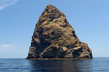
Jabuka (island)


Jabuka (pronounced [jâbuka], which means apple in Croatian) is an uninhabited volcanic island in the Adriatic Sea, west of the island of Vis.[1][2] It is part of the Dalmatian archipelago. The closest land masses are the small islands of Svetac and Brusnik. Jabuka is the farthest from the nearest land mass out of all Croatian islands.
Flora and fauna
Its coast is steep and difficult to approach, and landings can be made only when the weather is clear.[3] The easiest access is on the south-west side. On the island, noteworthy species such as a Dalmatian Wall Lizard and some plants (Centaurea jabukensis and Centaurea crithmifolia, both Asteraceae) are protected endemics. In 1958 the island was declared a geological monument of nature. The surrounding sea is rich with fish, especially sea bream. However, due to remoteness, lack of safe harbour, strong currents, and sudden changes of weather, fishermen have traditionally avoided the waters around Jabuka.[4]
Birds
Jabuka, along with Vis, Sveti Andrija and its neighbouring islet of Kamnik, Brusnik, Biševo and the Palagruža archipelago, forms part of the Croatian Offshore Islands Important Bird Area (IBA). This was designated as such by BirdLife International because it supports significant breeding populations of Scopoli's and Yelkouan shearwaters, as well as of Eleonora's falcons.[5]
Geological features
Jabuka has 97-meter (318 ft) tall cliffs. The island is composed of igneous magnetite rocks,[6] which cause magnetic anomalies that confuse compasses.[7] Due to its iron-rich rock, Jabuka is frequently struck by lightning.[8]: 177
The area around the island is prone to earthquakes due to the Jabuka–Andrija Fault. In 2003, the island was struck by a long series of earthquakes, the largest of which was Mw 5.5.[8] Another series occurred in 2004–05 with a ML 5.2 quake.[9]: 100–101 However, due to Jabuka's remoteness, these earthquakes are weakly felt on the Croatian mainland and inhabited islands.
References
- ^ Walking in Croatia by Rudolf Abraham
- ^ Frommer's Croatia by Karen Torme Olson
- ^ Šerić 2006, p. 15.
- ^ Šerić 2006, pp. 12, 14.
- ^ "Offshore Islands". BirdLife Data Zone. BirdLife International. 2024. Retrieved 2024-08-25.
- ^ Petrinec, Branko; Franic, Zdenko; Leder, Nenad; Tsabaris, Christos; Bituh, Tomislav; Marovic, Gordana (June 2010). "Gamma radiation and dose rate investigations on the Adriatic islands of magmatic origin". Radiation Protection Dosimetry. 139 (4): 551–559. doi:10.1093/rpd/ncp302. PMID 20085897.
- ^ PÁLINKÁS, LADISLAV A; SOSTARIC, SIBILA BOROJEVIC; PÁLINKÁS, SABINA STRMIC; CRNJAKOVIC, MARTA; NEUBAUER, FRANZ; MOLNÁR, FERENC; BERMANEC, VLADIMIR. "Volcanoes in the Adriatic Sea: Permo-Triassic magmatism on the Adriatic-Dinaridic carbonate platform" (PDF). Acta Mineralogica-Petrographica, Field Guide Series. 8: 1-15.
- ^ a b Herak, Davorka; Herak, Marijan; Prelogović, Eduard; Markušić, Snježana; Markulin, Željko (April 2005). "Jabuka island (Central Adriatic Sea) earthquakes of 2003". Tectonophysics. 398 (3–4): 167–180. Bibcode:2005Tectp.398..167H. doi:10.1016/j.tecto.2005.01.007.
- ^ Ivančić, Ines; Herak, Davorka; Markušić, Snježana; Sović, Ivica; Herak, Marijan (30 December 2006). "Seismicity of Croatia in the period 2002-2005". Geofizika. 23 (2): 87–103. ISSN 0352-3659. Retrieved 19 April 2022.
Bibliography
- Šerić, Neven (2006). Biserna ogrlica - pučinski otoci srednjeg Jadrana (RTF) (in Croatian). Marjan tisak. ISBN 953-214-367-X. Retrieved 5 July 2018.
