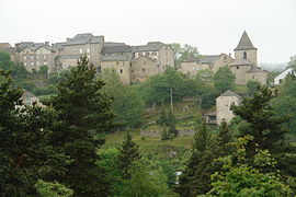
Grandrieu
Grandrieu | |
|---|---|
 Gandrieu from across the valley | |
| Coordinates: 44°47′07″N 3°38′02″E / 44.7853°N 3.6339°E | |
| Country | France |
| Region | Occitania |
| Department | Lozère |
| Arrondissement | Mende |
| Canton | Grandrieu |
| Intercommunality | CC Randon - Margeride |
| Government | |
| • Mayor (2020–2026) | Guy Galtier[1] |
Area 1 | 65.37 km2 (25.24 sq mi) |
| Population (2022)[2] | 742 |
| • Density | 11/km2 (29/sq mi) |
| Time zone | UTC+01:00 (CET) |
| • Summer (DST) | UTC+02:00 (CEST) |
| INSEE/Postal code | 48070 /48600 |
| Elevation | 867–1,317 m (2,844–4,321 ft) (avg. 1,160 m or 3,810 ft) |
| 1 French Land Register data, which excludes lakes, ponds, glaciers > 1 km2 (0.386 sq mi or 247 acres) and river estuaries. | |
Grandrieu (French pronunciation: [gʁɑ̃ʁjø]; Occitan: Grandriu) is a village and commune in the Lozère department in southern France.[3] In February 1965, it absorbed the former commune Sainte-Colombe-de-Montauroux.[4]
Geography
The Chapeauroux forms parts of the commune's north-eastern border.
See also
References
- ^ "Répertoire national des élus: les maires" (in French). data.gouv.fr, Plateforme ouverte des données publiques françaises. 13 September 2022.
- ^ "Populations de référence 2022" (in French). The National Institute of Statistics and Economic Studies. 19 December 2024.
- ^ INSEE commune file
- ^ Modifications aux circonscriptions territoriales de communes, Journal officiel de la République française n° 0044, 21 February 1965, pp. 1483-1485.


