Gerville
Gerville | |
|---|---|
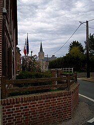
 The church in Gerville | |
| Coordinates: 49°41′48″N 0°19′49″E / 49.6967°N 0.3303°E | |
| Country | France |
| Region | Normandy |
| Department | Seine-Maritime |
| Arrondissement | Le Havre |
| Canton | Fécamp |
| Intercommunality | CA Fécamp Caux Littoral |
| Government | |
| • Mayor (2020–2026) | Estelle Guénot |
Area 1 | 3.01 km2 (1.16 sq mi) |
| Population (2022)[1] | 421 |
| • Density | 140/km2 (360/sq mi) |
| Time zone | UTC+01:00 (CET) |
| • Summer (DST) | UTC+02:00 (CEST) |
| INSEE/Postal code | 76300 /76790 |
| Elevation | 90–125 m (295–410 ft) (avg. 102 m or 335 ft) |
| 1 French Land Register data, which excludes lakes, ponds, glaciers > 1 km2 (0.386 sq mi or 247 acres) and river estuaries. | |
Gerville (French pronunciation: [ʒɛʁvil]) is a commune in the Seine-Maritime department in the Normandy region in northern France.[2]
Geography
A farming village situated in the Pays de Caux, some 16 miles (26 km) northeast of Le Havre, at the junction of the D79 and D11 roads.
The commune comprises 6 hamlets or place-names: La Mare Chanseuse, Le Bihorel, La Hêtrée, Le Parlement, Le Beau Soleil and Vue-du-Coquet
Heraldry
 |
The arms of Gerville are blazoned : Argent, on a bend azure between 2 phrygian caps gules, 3 mullets (of 6) voided Or.
|
Population
| Year | Pop. | ±% p.a. |
|---|---|---|
| 1968 | 272 | — |
| 1975 | 235 | −2.07% |
| 1982 | 250 | +0.89% |
| 1990 | 351 | +4.33% |
| 1999 | 381 | +0.92% |
| 2007 | 413 | +1.01% |
| 2012 | 377 | −1.81% |
| 2017 | 424 | +2.38% |
| Source: INSEE[3] | ||
Places of interest

- The church of St.Michel, dating from the nineteenth century.
- The remains of a 19th-century chateau, destroyed by fire in 1944.
See also
References
- ^ "Populations de référence 2022" (in French). The National Institute of Statistics and Economic Studies. 19 December 2024.
- ^ "Commune de Gerville (76300)". INSEE. Retrieved 8 October 2024.
- ^ Population en historique depuis 1968, INSEE
External links
- Guénot, Estelle. "Le blog de la mairie de Gerville". Le blog de la mairie de Gerville (in French). Retrieved 2023-10-07.
- "Gerville". Fécamp Caux Littoral (in French). Retrieved 2023-10-07.
- "Mairie - Gerville - Seine-Maritime - 76 - Annuaire | Service-public.fr". lannuaire.service-public.fr. Retrieved 2023-10-07.


