Formazza
Formazza Púmâtt (Walser) | |
|---|---|
| Comune di Formazza | |
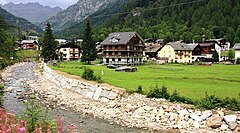
 Mountains in Formazza | |
| Coordinates: 46°23′N 8°26′E / 46.383°N 8.433°E | |
| Country | Italy |
| Region | Piedmont |
| Province | Province of Verbano-Cusio-Ossola (VB) |
| Frazioni | Foppiano, Antillone, Fondovalle, Chiesa, Valdo, San Michele, Ponte (communal seat), Brendo, Grovella, Canza, Sotto Frua, La Frua, Riale |
| Government | |
| • Mayor | Bruna Piera Papa |
| Area | |
• Total | 130.65 km2 (50.44 sq mi) |
| Elevation | 1,280 m (4,200 ft) |
| Population (30 June 2017)[2] | |
• Total | 438 |
| • Density | 3.4/km2 (8.7/sq mi) |
| Demonym | Formazzini |
| Time zone | UTC+1 (CET) |
| • Summer (DST) | UTC+2 (CEST) |
| Postal code | 28030 |
| Dialing code | 0324 |
| Website | Official website |
Formazza (Walser: Púmâtt; Ossolano: Formassa; German: Pomatt) is a comune (municipality) in the Province of Verbano-Cusio-Ossola in the Italian region Piedmont, located about 160 kilometres (99 mi) northeast of Turin and about 50 kilometres (31 mi) north of Verbania, on the border with Switzerland.
Formazza borders the following municipalities: Baceno, Bedretto (Switzerland), Bignasco (Switzerland), Binn (Switzerland), Bosco/Gurin (Switzerland), Cavergno (Switzerland), Premia, Reckingen-Gluringen (Switzerland), Ulrichen (Switzerland).
The village was founded by Walser and Walser German is still spoken.
| Year | Pop. | ±% |
|---|---|---|
| 1861 | 656 | — |
| 1871 | 683 | +4.1% |
| 1881 | 654 | −4.2% |
| 1901 | 515 | −21.3% |
| 1911 | 499 | −3.1% |
| 1921 | 517 | +3.6% |
| 1931 | 659 | +27.5% |
| 1936 | 748 | +13.5% |
| 1951 | 732 | −2.1% |
| 1961 | 648 | −11.5% |
| 1971 | 577 | −11.0% |
| 1981 | 547 | −5.2% |
| 1991 | 461 | −15.7% |
| 2001 | 448 | −2.8% |
| 2011 | 442 | −1.3% |
| Source: ISTAT 2012 | ||
Geography and climate

The village is situated about an elevation of 1,200 metres (3,900 ft) above sea level on the Formazza plateau in Formazza valley. Its altitude and location directly under the high mountains of the western Alps influences the climate. In fact, there is an average of more than one meter and thirty centimeters of precipitation per year (especially snow). The climate is the type Dfb/Dfc (Köppen climate classification), which means it is a humid continental climate with fresh and short summers (but usually there is no dry season). The annual average temperature at one local weather station is about 4 °C (39 °F) and usually the coldest month (January) has a daily mean temperature of about −4 °C (25 °F). The lowest values can reach about −20 °C (−4 °F). The hottest month (July) has an average temperature of about 13 °C (55 °F) and the summer lasts less than three months.
Frazioni
Frazioni, or subdivisions of Formazza (first name in Italian, second name in Walser):
- Antillone / Puneigä
- Brendo / In dä Brendu
- Canza / Früttwald - Früduwald
- Chiesa - Alla Chiesa / Zer Chilchu - Andermatten - An där Mattu - In där Mattu
- Fondovalle / Stafelwald - Schtaafuwaald
- Foppiano / Untermstalden - Unnerum Schtaldä
- Frua / Uf der Frütt
- Sotto Frua / Unter der Frütt
- Grovella / Gurfelen - Gurfelä
- Morasco / Moraschg
- Ponte - Al Ponte / Zum Steg - Zumstäg - Zumschtäg - Zer Briggu
- Riale / Kehrbäch(i) - Cherbäch
- Valdo / Wald - Waald
- San Michele / Tuffwaald - Tuffalt
People
- Mario Bacher (b. 1941), ski mountaineer and cross-country skier
References
- ^ "Superficie di Comuni Province e Regioni italiane al 9 ottobre 2011". Italian National Institute of Statistics. Retrieved 16 March 2019.
- ^ All demographics and other statistics: Italian statistical institute Istat.


