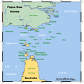
File:TorresStraitIslandsMap.png

Size of this preview: 604 × 599 pixels. Other resolutions: 242 × 240 pixels | 484 × 480 pixels | 929 × 922 pixels.
Original file (929 × 922 pixels, file size: 28 KB, MIME type: image/png)
File history
Click on a date/time to view the file as it appeared at that time.
| Date/Time | Thumbnail | Dimensions | User | Comment | |
|---|---|---|---|---|---|
| current | 06:42, 13 January 2022 |  | 929 × 922 (28 KB) | Kelisi | Reverted to version as of 00:09, 1 May 2007 (UTC) Hardly; those two colours are closer to each other. |
| 17:59, 6 October 2021 |  | 929 × 922 (31 KB) | Claude Zygiel | Better contrast | |
| 00:09, 1 May 2007 |  | 929 × 922 (28 KB) | Stanmar | {{Information |Description=A map of the Torres Strait Islands. I have endeavoured to use native names wherever I could find them. If you can suggest ways in which this map could be made more up to date, don't hesitate to leave me a message to that effect. |
File usage
The following 36 pages use this file:
- Adolphus Channel
- Bourke Isles
- Coconut Island (Queensland)
- Crab Island (Queensland)
- Darnley Island (Queensland)
- Duncan Islands
- Gebar Island
- Halfway Island (Queensland)
- Horn Island, Queensland
- Indigenous Australians
- Kaurareg
- List of Torres Strait Islands
- List of birds of the Torres Strait Islands
- List of butterflies of Australia
- Masig Island, Queensland
- Meriam people
- Moa Island (Queensland)
- Mount Adolphus Island
- Parama Island
- Prince of Wales Island (Queensland)
- Saibai Island
- Stephens Island (Torres Strait)
- Thursday Island
- Torres Strait Islanders
- Torres Strait Islands
- Travel document
- Trochus Island
- Turnagain Island (Queensland)
- Turtle Head Island
- Turtle Island (Newcastle Bay)
- Warul Kawa Indigenous Protected Area
- Yam Island
- User:Buerste333/Wednesday Island (Torres Strait)
- User:Cruickshanks/Sandbox
- User:Kelisi
- User:Student1306/sandbox
Global file usage
The following other wikis use this file:
- Usage on af.wikipedia.org
- Usage on als.wikipedia.org
- Usage on ar.wikipedia.org
- Usage on azb.wikipedia.org
- Usage on ba.wikipedia.org
- Usage on bg.wikipedia.org
- Usage on bn.wikipedia.org
- Usage on br.wikipedia.org
- Usage on ca.wikipedia.org
- Usage on ceb.wikipedia.org
- Usage on cs.wikipedia.org
- Usage on cy.wikipedia.org
- Usage on da.wikipedia.org
- Usage on de.wikipedia.org
- Torres-Straße
- Prince-of-Wales-Insel (Queensland)
- Torres-Straits-Expedition
- Bellevue-Inseln
- Mabuiag
- Talbot-Inseln
- Boigu
- Flagge der Torres-Strait-Insulaner
- Manar-Inseln
- Thursday Island
- Horn Island (Torres Strait)
- Saibai
- Thursday-Inseln
- The Three Sisters (Torres Strait)
- Dauan
- Bet Island
- Poll Island
- Sue Island
- Murray-Inseln
- Murray Island
- Badu Island
- Moa Island
- Coconut Island (Australien)
- Yam Island
- Hammond Island
- Goods Island
- Friday Island (Torres Strait)
View more global usage of this file.


