
File:Relief Map of Altai Krai.jpg

Size of this preview: 800 × 597 pixels. Other resolutions: 320 × 239 pixels | 640 × 478 pixels | 1,024 × 765 pixels | 1,200 × 896 pixels.
Original file (1,200 × 896 pixels, file size: 157 KB, MIME type: image/jpeg)
Summary
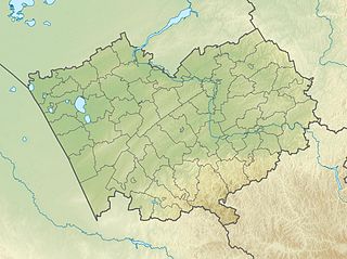
| Description | Русский: Физическая карта Алтайского края
|top = 55 |bottom = 50 |left = 77 |right = 88 |
| Date | |
| Source | |
| Author | Виктор В |
| Other versions |
|


Licensing
This file is licensed under the Creative Commons Attribution-Share Alike 2.0 Generic license.
- You are free:
- to share – to copy, distribute and transmit the work
- to remix – to adapt the work
- Under the following conditions:
- attribution – You must give appropriate credit, provide a link to the license, and indicate if changes were made. You may do so in any reasonable manner, but not in any way that suggests the licensor endorses you or your use.
- share alike – If you remix, transform, or build upon the material, you must distribute your contributions under the same or compatible license as the original.
File history
Click on a date/time to view the file as it appeared at that time.
| Date/Time | Thumbnail | Dimensions | User | Comment | |
|---|---|---|---|---|---|
| current | 17:10, 26 September 2010 | | 1,200 × 896 (157 KB) | Виктор В | == {{int:filedesc}} == {{Information |Description={{ru|1=Физическая карта Алтайского края *Проекция — равноугольная. *Стандартная параллель — 52°30'с.ш. *Параметры ша� |
File usage
The following 52 pages use this file:
- Bakhmatovskoye
- Barnaulka
- Bauzhansor
- Belenkoye (lake, Slavgorod Municipality)
- Belenkoye (lake, Tabunsky District)
- Biya (river)
- Bolshoye Ostrovnoye
- Bolshoye Shklo
- Bolshoye Topolnoye
- Bolshoye Yarovoye
- Bura (lake)
- Burla (river)
- Burlinskoye
- Chumysh
- Denisova Cave
- Dzhira
- Gorkiye Kilty
- Gorkoye-Peresheyechnoye
- Gorkoye (Chernokurynskoye)
- Gorkoye (Novichikhinsky District)
- Gorkoye (Romanovsky District)
- Gorkoye (Tyumentsevsky District)
- Gorkoye (Yegoryevsky District)
- Gornostalevo
- Ilyinka, Shelabolikhinsky District, Altai Krai
- Ilyinka, Shipunovsky District, Altai Krai
- Kasmala (river)
- Krivaya Puchina
- Kuchuk (river)
- Kulunda (river)
- Lake Kuchuk
- Lake Kulunda
- Malinovoye (lake)
- Maloye Yarovoye
- Mayak Shangina
- Mostovoye (lake)
- Okladnikov Cave
- Peschanoye (Barnaulka basin)
- Peschanoye (Burla basin)
- Petukhovo (lake)
- Petukhovskoye (lake)
- Shchekulduk
- Shukyrtuz
- Sredneye (lake, Altai Krai)
- Topolnoye (lake)
- Ust-Porozikha
- Zerkalnoye (Altai Krai)
- Zhigilda
- User:Fraenir/AncientDNA
- User:Paris1127/Barnaulka River
- Module:Location map/data/Russia Altai Krai
- Module:Location map/data/Russia Altai Krai/doc
Global file usage
The following other wikis use this file:
- Usage on alt.wikipedia.org
- Usage on ar.wikipedia.org
- Usage on az.wikipedia.org
- Usage on ba.wikipedia.org
- Usage on be.wikipedia.org
- Usage on bg.wikipedia.org
- Usage on ceb.wikipedia.org
- Usage on ce.wikipedia.org
- Usage on cs.wikipedia.org
- Usage on da.wikipedia.org
- Usage on de.wikipedia.org
- Usage on el.wikipedia.org
- Usage on eo.wikipedia.org
View more global usage of this file.