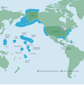
File:NOAA Map of the US EEZ.svg

Size of this PNG preview of this SVG file: 599 × 600 pixels. Other resolutions: 240 × 240 pixels | 479 × 480 pixels | 767 × 768 pixels | 1,022 × 1,024 pixels | 2,045 × 2,048 pixels | 612 × 613 pixels.
Original file (SVG file, nominally 612 × 613 pixels, file size: 1.93 MB)
File history
Click on a date/time to view the file as it appeared at that time.
| Date/Time | Thumbnail | Dimensions | User | Comment | |
|---|---|---|---|---|---|
| current | 02:45, 3 May 2022 |  | 612 × 613 (1.93 MB) | NuclearElevator | Re-converted the PDF to SVG using Inkscape's "Popplar/Cairo Import" instead of its "Internal Import" to fix text rendering issue on Wikimedia's PNG versions of the file |
| 02:36, 3 May 2022 |  | 816 × 817 (1.2 MB) | NuclearElevator | Uploaded a work by National Oceanic and Atmospheric Administration from http://www.gc.noaa.gov/documents/2011/012711_gcil_maritime_eez_map.pdf with UploadWizard |
File usage
The following 10 pages use this file:
Global file usage
The following other wikis use this file:
- Usage on bn.wikipedia.org
- Usage on ckb.wikipedia.org
- Usage on dtp.wikipedia.org
- Usage on fa.wikipedia.org
- Usage on he.wikipedia.org
- Usage on iba.wikipedia.org
- Usage on id.wikipedia.org
- Usage on incubator.wikimedia.org
- Usage on ko.wikipedia.org
- Usage on pa.wikipedia.org
- Usage on pt.wikipedia.org
- Usage on shn.wikipedia.org
- Usage on so.wikipedia.org
- Usage on ta.wikipedia.org
- Usage on th.wikipedia.org
- Usage on tum.wikipedia.org

